
Акс:Alaska pipeline route near Valdez River.jpg

Андозаи ин пешнамоиш: 800 × 537 пиксел. Дигар кайфиятҳо: 320 × 215 пиксел | 640 × 429 пиксел | 1 024 × 687 пиксел | 1 280 × 859 пиксел | 2 898 × 1 944 пиксел.
Акси аслӣ ((2 898 × 1 944 пиксел, ҳаҷми парванда: 1,09 Мбайт, навъи MIME: image/jpeg))
| This is a retouched picture, which means that it has been digitally altered from its original version. Modifications: crop and color correct. The original can be viewed here: VIEW NORTHEAST ACROSS VALDEZ RIVER FLOODPLAIN SHOWING PIPE STORAGE YARD, CENTER FOREGROUND, WHICH HOLDS 418 MILES OF... - NARA - 555685.jpg:
|
| Тавсифот |
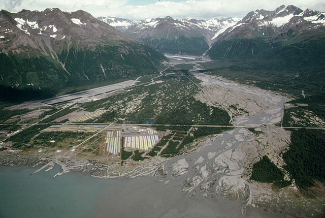
The following is the author's description of the photograph quoted directly from the photograph's Flickr page. "Original Caption: View Northeast Across Valdez River Floodplain Showing Pipe Storage Yard, Center Foreground, Which Holds 418 Miles of Pipe Yards at Fairbanks and Prudhoe Bay Hold 238 and 168 Miles of Pipe Respectively. The Community's Airport, Paved in the Summer of 1974 Sits at the Base of West Peak (Elevation 5,255 Feet). Mile 788, near the Alaska Pipeline Route 08/1974 U.S. National Archives%u2019 Local Identifier: 412-DA-13233 Photographer: Cowals, Dennis, 1945- Subjects: Alaska (United States) state Environmental Protection Agency Project DOCUMERICA Persistent URL: https://arcweb.archives.gov/arc/action/ExternalIdSearch?id=555685 Repository: Still Picture Records Section, Special Media Archives Services Division (NWCS-S), National Archives at College Park, 8601 Adelphi Road, College Park, MD, 20740-6001. For information about ordering reproductions of photographs held by the Still Picture Unit, visit: www.archives.gov/research/order/still-pictures.html Reproductions may be ordered via an independent vendor. NARA maintains a list of vendors at www.archives.gov/research/order/vendors-photos-maps-dc.html Access Restrictions: Unrestricted Use Restrictions: Unrestricted " |
||
| Сана | |||
| Манбаъ |
originally posted to Flickr as View Northeast Across Valdez River Floodplain Showing Pipe Storage Yard, Center Foreground, Which Holds 418 Miles of Pipe Yards at Fairbanks and Prudhoe Bay Hold 238 and 168 Miles of Pipe Respectively...08/1974
|
||
| Муаллиф | [1] | ||
| Иҷозат (Пешроҳандозии ин парванда) |
This file is licensed under the Creative Commons Attribution 2.0 Generic license.
|
| Annotations | This image is annotated: View the annotations at Commons |
Таърихи файл
Рӯи таърихҳо клик кунед то нусхаи марбути парвандаро бубинед.
| Таърих | Бандангуштӣ | Андоза | Корбар | Тавзеҳ | |
|---|---|---|---|---|---|
| нусхаи феълӣ | 01:43, 2 июли 2011 | | 2 898 × 1 944 (1,09 Мбайт) | Hohum | Cropped, levels |
| 05:36, 16 ноябри 2009 |  | 3 000 × 2 048 (1,08 Мбайт) | Geo Swan | {{Information |Description=The following is the author's description of the photograph quoted directly from the photograph's Flickr page.<br/>"'''Original Caption:''' View Northeast Across Valdez River Floodplain Showing Pipe Storage Yard, Center Foregrou |
Пайвандҳо
Саҳифаҳои зерин ба ин акс пайванданд:
Истифодаи саросарии парванда
Викиҳои дигари зерин ин файлро истифода мекунанд:
- Истифода дар arz.wikipedia.org
- Истифода дар ceb.wikipedia.org
- Истифода дар de.wikipedia.org
- Истифода дар en.wikipedia.org
- Истифода дар en.wikivoyage.org
- Истифода дар fa.wikipedia.org
- Истифода дар it.wikipedia.org
- Истифода дар ja.wikipedia.org
- Истифода дар pl.wikipedia.org
- Истифода дар ru.wikipedia.org
- Истифода дар www.wikidata.org