
Акс:Japan location map with side map of the Ryukyu Islands.svg

Акси аслӣ (SVG парванда, исмӣ 413 × 373 пиксел, андозаи парванда: 980 кбайт)
Хулоса
| Тавсифот |
Deutsch: Postionskarte von Japan
Quadratische Plattkarte. Bei Nutzung der Hauptkarte mit den Hauptinseln gelten folgende geographische Begrenzungen für die (Gesamt-)Karte:
Bei Nutzung der Nebenkarte mit den Ryūkyū-Inseln gelten folgende geographische Begrenzungen für die (Gesamt-)Karte:
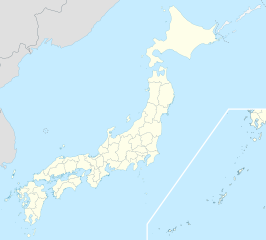
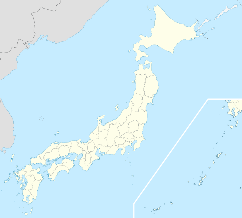
English: Location map of Japan
Equirectangular projection. Geographic limits to locate objects in the main map with the main islands:
Geographic limits to locate objects in the side map with the Ryukyu Islands:
日本語: 日本国の地図。
正距円筒図法。 南西諸島以外の日本を描いたメインの地図が示す領域:
南西諸島を描いた右下の地図が示す領域:
|
||
| Сана | |||
| Манбаъ | Кори худ | ||
| Муаллиф | Maximilian Dörrbecker (Chumwa) | ||
| Иҷозат (Пешроҳандозии ин парванда) |
I, the copyright holder of this work, hereby publish it under the following licenses:
This file is licensed under the Creative Commons Attribution-Share Alike 3.0 Unported license.
Шумо иҷозатномаи хостаи худро интихоб карда метавонед. |
||
| Other versions |
Derivative works of this file: |
||
| SVG genesis | This map was created with Adobe Illustrator.
|


Таърихи файл
Рӯи таърихҳо клик кунед то нусхаи марбути парвандаро бубинед.
| Таърих | Бандангуштӣ | Андоза | Корбар | Тавзеҳ | |
|---|---|---|---|---|---|
| нусхаи феълӣ | 14:21, 3 апрели 2022 | | 413 × 373 (980 кбайт) | Peka | Reverted to version as of 10:18, 10 August 2021; no discuss about this change |
| 10:18, 10 августи 2021 |  | 413 × 373 (1,56 Мбайт) | 호로조 | Liancourts Rock isn't territory of Japan | |
| 05:19, 14 ноябри 2020 |  | 413 × 373 (980 кбайт) | AichiWikiFixer | Fix borders. | |
| 13:53, 30 октябри 2010 |  | 413 × 373 (926 кбайт) | NordNordWest | Liancourts Rock boundary | |
| 01:15, 17 сентябри 2010 |  | 413 × 373 (1,56 Мбайт) | Dinamik | medium color for disputed territories | |
| 11:41, 21 марти 2010 |  | 413 × 373 (1,52 Мбайт) | Chumwa | Präfekturgrenzen bereinigt | |
| 13:33, 20 марти 2010 |  | 413 × 373 (1,71 Мбайт) | Chumwa | Trennlinie zu Nebenkarte etwas verbreitert | |
| 09:50, 20 марти 2010 |  | 413 × 373 (1,92 Мбайт) | Chumwa | == {{int:filedesc}} == {{Information |Description= {{de|Postionskarte von Japan}} Quadratische Plattkarte. Bei Nutzung der Hauptkarte mit den Hauptinseln gelten folgende geographische Begrenzungen für die (Gesamt-)Karte: * N: 45°51'37" N |
Пайвандҳо
More than 100 pages use this file. The following list shows the first 100 pages that use this file only. A full list is available.
- Болгардгоҳи Токио
- Пойгоҳи имконот ҳаво отсуги
- Пойгоҳи ҳавоии Ирума
- Пойгоҳи ҳавоии Касумигаура
- Пойгоҳи ҳавоии Касуминоме
- Пойгоҳи ҳавоии Кисаразу
- Пойгоҳи ҳавоии Нютабару
- Пойгоҳи ҳавоии Татейама
- Пойгоҳи ҳавоии Шизуҳама
- Пойгоҳи ҳавоии Шимофуса
- Пойгоҳи ҳавоии Ҳамаматсу
- Пойгоҳи ҳавоии Ҳачиноҳе
- Саиҷо
- Фурудгоҳи Байналмиллалии Кансай
- Фурудгоҳи Байналмиллалии Осака
- Фурудгоҳи Кобе
- Фурудгоҳи Миязаки
- Фурудгоҳи Монбетсу
- Фурудгоҳи Окушири
- Фурудгоҳи Таҷима
- Фурудгоҳи Хонда
- Фурудгоҳи Ямагата
- Фурудгоҳи вокон, هвкоиду
- Фурудгоҳи гирод мантақа овминту
- Фурудгоҳи иоеҳв
- Фурудгоҳи иокушимо
- Фурудгоҳи иомогучи овбҳ
- Фурудгоҳи иҷимо
- Фурудгоҳи кик
- Фурудгоҳи кинеё муиол
- Фурудгоҳи китодоиту
- Фурудгоҳи китокюшу
- Фурудгоҳи когушимо
- Фурудгоҳи комигуту
- Фурудгоҳи кромо
- Фурудгоҳи кузушимо
- Фурудгоҳи кукуро
- Фурудгоҳи кумимо
- Фурудгоҳи кумомуту
- Фурудгоҳи кумотсу
- Фурудгоҳи кунон
- Фурудгоҳи куширу
- Фурудгоҳи кӯч
- Фурудгоҳи мииоку
- Фурудгоҳи мииокҷимо
- Фурудгоҳи миноми-доиту
- Фурудгоҳи миноми туришимо
- Фурудгоҳи миҳу-юногу
- Фурудгоҳи ммонбтсу
- Фурудгоҳи мовнтн вилҷ
- Фурудгоҳи мовнтндил
- Фурудгоҳи мотсуиомо
- Фурудгоҳи мотсумуту
- Фурудгоҳи мудонҷионг ҳоилонг
- Фурудгоҳи нонки–широҳомо
- Фурудгоҳи нуту
- Фурудгоҳи овдотҳ-нуширу
- Фурудгоҳи овиико
- Фурудгоҳи овито
- Фурудгоҳи овки
- Фурудгоҳи овкинуробу
- Фурудгоҳи овкиёмо
- Фурудгоҳи овкодомо
- Фурудгоҳи овшимо
- Фурудгоҳи оибороки
- Фурудгоҳи оизуму
- Фурудгоҳи оики
- Фурудгоҳи оишигоки
- Фурудгоҳи оюоми
- Фурудгоҳи рбун
- Фурудгоҳи ришири
- Фурудгоҳи саҳро конуио
- Фурудгоҳи саҳро мотсушимо
- Фурудгоҳи саҳро мтобру
- Фурудгоҳи саҳро муиглор
- Фурудгоҳи саҳро овзуки
- Фурудгоҳи саҳро отсунумио
- Фурудгоҳи саҳро тсуеҳики
- Фурудгоҳи сго
- Фурудгоҳи снд
- Фурудгоҳи соду
- Фурудгоҳи токомотсу
- Фурудгоҳи торомо
- Фурудгоҳи точиково
- Фурудгоҳи тсушимо
- Фурудгоҳи туиомо
- Фурудгоҳи тукочи
- Фурудгоҳи тукочи-овбиҳиру
- Фурудгоҳи тукушимо
- Фурудгоҳи тукушимо (шаҳр)
- Фурудгоҳи тутури
- Фурудгоҳи шизуко
- Фурудгоҳи шимуҷишимо
- Фурудгоҳи шуноии
- Фурудгоҳи юногуни
- Фурудгоҳи юрун
- Фурудгоҳи ҳерушемо
- Фурудгоҳи ҳокудотҳ
- Фурудгоҳи ҳономоки
- Фурудгоҳи ҳотрумо
View more links to this file.
Истифодаи саросарии парванда
Викиҳои дигари зерин ин файлро истифода мекунанд:
- Истифода дар ace.wikipedia.org
- Истифода дар af.wikipedia.org
- Osaka
- Hirosjima
- Tokio
- Nara, Nara
- Kioto
- Nagasaki
- Jokohama
- Nagoja
- Sapporo
- Kobe
- Nagano
- FIFA Sokker-Konfederasiebeker in 2001
- Nanao
- Rugbywêreldbeker 2019
- Fukuoka
- Kawasaki
- Saitama
- Sendai
- Kitakyushu
- Chiba
- Tokio-Haneda Internasionale Lughawe
- Narita Internasionale Lughawe
- Kansai Internasionale Lughawe
- Toyota, Aichi
- Groep van Sewe
- Saga (stad)
- Истифода дар als.wikipedia.org
- Истифода дар an.wikipedia.org
- Истифода дар ar.wikipedia.org
View more global usage of this file.