
Акс:South Sudan topographic map.svg

Ҳаҷми пешнамоиши PNG барои файли кунунии SVG: 800 × 577 пиксел. Дигар кайфиятҳо: 320 × 231 пиксел | 640 × 462 пиксел | 1 024 × 738 пиксел | 1 280 × 923 пиксел | 2 560 × 1 846 пиксел | 1 553 × 1 120 пиксел.
Акси аслӣ (SVG парванда, исмӣ 1 553 × 1 120 пиксел, андозаи парванда: 759 кбайт)
Хулоса
| Тавсифот |
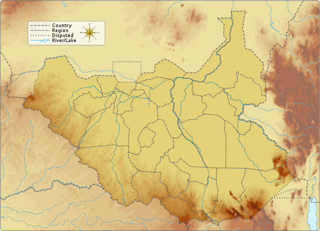
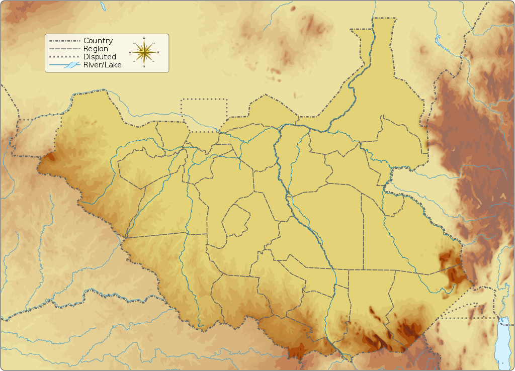
English: Topographic map of South Sudan.
|
||||||||||||||||||||||
| Сана | |||||||||||||||||||||||
| Манбаъ |
Кори худ Information from:
|
||||||||||||||||||||||
| Муаллиф | Goran_tek-en | ||||||||||||||||||||||
| Иҷозат (Пешроҳандозии ин парванда) |
This file is licensed under the Creative Commons Attribution-Share Alike 4.0 International license. Тахсис: Goran tek-en
|
||||||||||||||||||||||
| Other versions |
|
||||||||||||||||||||||
| SVG genesis | This vector image was created with Inkscape.
|
||||||||||||||||||||||

| Object location | | View this and other nearby images on: OpenStreetMap |
|---|


Иҷозатнома
This file is licensed under the Creative Commons Attribution-Share Alike 4.0 International license.
Тахсис: Goran tek-en
- Шумо озодед:
- мубодилот намудан – копӣ, паҳн ва фиристадани асар
- ремикс кардан – татбиқи кор
- Under the following conditions:
- тахсис – You must give appropriate credit, provide a link to the license, and indicate if changes were made. You may do so in any reasonable manner, but not in any way that suggests the licensor endorses you or your use.
- саҳми яксон – If you remix, transform, or build upon the material, you must distribute your contributions under the same or compatible license as the original.
Таърихи файл
Рӯи таърихҳо клик кунед то нусхаи марбути парвандаро бубинед.
| Таърих | Бандангуштӣ | Андоза | Корбар | Тавзеҳ | |
|---|---|---|---|---|---|
| нусхаи феълӣ | 15:32, 5 сентябри 2016 | | 1 553 × 1 120 (759 кбайт) | Goran tek-en | User created page with UploadWizard |
Пайвандҳо
Саҳифаҳои зерин ба ин акс пайванданд:
Истифодаи саросарии парванда
Викиҳои дигари зерин ин файлро истифода мекунанд:
- Истифода дар ab.wikipedia.org
- Истифода дар ar.wikipedia.org
- Истифода дар av.wikipedia.org
- Истифода дар az.wikipedia.org
- Истифода дар be.wikipedia.org
- Истифода дар bn.wikipedia.org
- Истифода дар bs.wikipedia.org
- Истифода дар ceb.wikipedia.org
- Истифода дар ce.wikipedia.org
- Истифода дар cs.wikipedia.org
- Истифода дар de.wikivoyage.org
- Истифода дар din.wikipedia.org
- Истифода дар dsb.wikipedia.org
- Истифода дар el.wikipedia.org
- Истифода дар en.wikipedia.org
- Kidepo River
- Kinyeti
- Lake No
- Bahr el Zeraf
- Pibor River
- Akobo River
- Jur River
- Unity oilfield
- Jikawo River
- Yabus River
- Boma National Park
- Nimule National Park
- Lantoto National Park
- Mbarizunga Game Reserve
- Bengangai Game Reserve
- Southern National Park
- Shambe National Park
- Chelkou Game Reserve
- Imatong Mountains
- Kongkong River
- Kangen River
- Lotilla River
- Kuru River
- Pongo River (South Sudan)
- Wau River
- Didinga Hills
- Daga River (South Sudan)
- Adar River
View more global usage of this file.