
Акс:Vakhsh.JPG

Андозаи ин пешнамоиш: 592 × 600 пиксел. Дигар кайфиятҳо: 237 × 240 пиксел | 474 × 480 пиксел | 758 × 768 пиксел | 1 052 × 1 066 пиксел.
Акси аслӣ ((1 052 × 1 066 пиксел, ҳаҷми парванда: 199 кбайт, навъи MIME: image/jpeg))
Хулоса
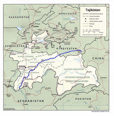
Map showing the Vakhsh River through Kyrgyzstan and Tajikistan. Derived by me from a CIA map located at the Perry-Castañeda Library (PCL) of the University of Texas at Austin map collection here. - Bantman 22:04, August 30, 2005 (UTC)
Иҷозатнома
This work is in the public domain in the United States because it is a work prepared by an officer or employee of the United States Government as part of that person’s official duties under the terms of Title 17, Chapter 1, Section 105 of the US Code.
Note: This only applies to original works of the Federal Government and not to the work of any individual U.S. state, territory, commonwealth, county, municipality, or any other subdivision. This template also does not apply to postage stamp designs published by the United States Postal Service since 1978. (See § 313.6(C)(1) of Compendium of U.S. Copyright Office Practices). It also does not apply to certain US coins; see The US Mint Terms of Use.
|
 | |
| This file has been identified as being free of known restrictions under copyright law, including all related and neighboring rights. | ||
Таърихи файл
Рӯи таърихҳо клик кунед то нусхаи марбути парвандаро бубинед.
| Таърих | Бандангуштӣ | Андоза | Корбар | Тавзеҳ | |
|---|---|---|---|---|---|
| нусхаи феълӣ | 18:04, 6 Декабри 2005 | | 1 052 × 1 066 (199 кбайт) | Bantman~commonswiki | Map showing the Vakhsh River through Kyrgyzstan and Tajikistan. Derived by me from a CIA map located at the Perry-Castañeda Library (PCL) of the University of Texas at Austin map collection [http://www.li |
Пайвандҳо
Ин акс дар ҳеҷ саҳифа истифода намешавад.
Истифодаи саросарии парванда
Викиҳои дигари зерин ин файлро истифода мекунанд:
- Истифода дар ar.wikipedia.org
- Истифода дар az.wikipedia.org
- Истифода дар bcl.wikipedia.org
- Истифода дар be.wikipedia.org
- Истифода дар bg.wikipedia.org
- Истифода дар ca.wikipedia.org
- Истифода дар ceb.wikipedia.org
- Истифода дар cs.wikipedia.org
- Истифода дар da.wikipedia.org
- Истифода дар de.wikipedia.org
- Истифода дар en.wikipedia.org
- Истифода дар es.wikipedia.org
- Истифода дар et.wikipedia.org
- Истифода дар eu.wikipedia.org
- Истифода дар fa.wikipedia.org
- Истифода дар fi.wikipedia.org
- Истифода дар fr.wikipedia.org
- Истифода дар hi.wikipedia.org
- Истифода дар hu.wikipedia.org
- Истифода дар hy.wikipedia.org
- Истифода дар id.wikipedia.org
- Истифода дар ja.wikipedia.org
- Истифода дар ko.wikipedia.org
- Истифода дар ky.wikipedia.org
- Истифода дар lt.wikipedia.org
- Истифода дар ml.wikipedia.org
- Истифода дар nl.wikipedia.org
- Истифода дар no.wikipedia.org
- Истифода дар pl.wikipedia.org
- Истифода дар pnb.wikipedia.org
- Истифода дар pt.wikipedia.org
- Истифода дар ru.wikipedia.org
- Истифода дар sv.wikipedia.org
- Истифода дар th.wikipedia.org
- Истифода дар tr.wikipedia.org
- Истифода дар uk.wikipedia.org
- Истифода дар uz.wikipedia.org
- Истифода дар vi.wikipedia.org
- Истифода дар www.wikidata.org
- Истифода дар zh.wikipedia.org