
Акс:Carte Empire-Khmer.png
Нусхаи ҳаҷман ва сифатан баландтар дастрас нест.
Carte_Empire-Khmer.png ((435 × 445 пиксел, ҳаҷми парванда: 33 кбайт, навъи MIME: image/png))
Хулоса
| Тавсифот |
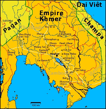
Carte de l'empire khmer à son apogée, au XIIe siècle sous Jayavarman VII avec les principaux sites visibles aujourd'hui. Illustration personnelle libre de droits sur base d'une carte OMC. English: French Map of Khmer Empire under Jayavarman VII. |
| Сана | 8 август 2005 (original upload date) |
| Манбаъ | Transferred from fr.wikipedia to Commons. |
| Муаллиф | Lozère at франсузӣ Википедия |
Иҷозатнома
| I, the copyright holder of this work, release this work into the public domain. This applies worldwide. In some countries this may not be legally possible; if so: I grant anyone the right to use this work for any purpose, without any conditions, unless such conditions are required by law. |
Original upload log
The original description page was here. All following user names refer to fr.wikipedia.
- 2006-04-15 20:33 Lozère 435×445×8 (33591 bytes) Avec les routes/With roads
- 2005-08-28 17:08 Lozère 435×445×8 (31287 bytes) Quelques ajouts
- 2005-08-09 19:51 Lozère 435×445×8 (44624 bytes) Etats actuels
- 2005-08-09 19:48 Lozère 435×445×8 (44246 bytes)
- 2005-08-08 15:02 Lozère 435×445×8 (29364 bytes) +Pagan
- 2005-08-08 14:31 Lozère 435×445×8 (41966 bytes) Carte de l'empire khmer à son apogée, au XIIe siècle sous Jayavarman VII avec les principaux sites visibles aujourd'hui. Illustration personnelle libre de droits sur base d'une carte OMC.
Таърихи файл
Рӯи таърихҳо клик кунед то нусхаи марбути парвандаро бубинед.
| Таърих | Бандангуштӣ | Андоза | Корбар | Тавзеҳ | |
|---|---|---|---|---|---|
| нусхаи феълӣ | 18:47, 15 марти 2007 | | 435 × 445 (33 кбайт) | Lozère | {{Information |Description=Carte de l'empire khmer à son apogée, au XIIe siècle sous Jayavarman VII avec les principaux sites visibles aujourd'hui. English: Map of Khmer Empire under Jayavarman VII. |Source=Own work, on the basis of an OMC map. |Date=1 |
| 21:15, 7 Декабри 2006 |  | 435 × 445 (31 кбайт) | Electionworld | {{ew|en|Ipower}} French Map of Khmer Empire under Jayavarman VII. == Licensing == {{PD}} Category:Maps of the history of Cambodia |
Пайвандҳо
Саҳифаҳои зерин ба ин акс пайванданд:
Истифодаи саросарии парванда
Викиҳои дигари зерин ин файлро истифода мекунанд:
- Истифода дар ba.wikipedia.org
- Истифода дар be.wikipedia.org
- Истифода дар bn.wikipedia.org
- Истифода дар bs.wikipedia.org
- Истифода дар de.wikipedia.org
- Истифода дар fa.wikipedia.org
- Истифода дар fi.wikipedia.org
- Истифода дар fi.wikibooks.org
- Истифода дар fr.wikipedia.org
- Architecture khmère
- Utilisateur:Lozère/Album
- Histoire du Cambodge
- Prasat Sdok Kok Thom
- Prasat Muang Sing
- Utilisateur:Ddalbiez
- Prasat Hin Phimai
- Prasat Phnom Wan
- Prang Khaek
- Wat Phra Sri Ratana Mahathat
- Phra Prang Sam Yod
- Kuti Reussi no 1
- Kuti Reussi no 2
- Prasat Sikhoraphum
- Prasat Tam Nak Sai
- Prasat Yer
- Prasat Sa Kamphaeng Yai
- Prasat Sa Kamphaeng Noi
- Prasat Ban Prasat
- Prasat Ban Muang Chan
- Prasat Prang Ku
- Prasat Hin Ban Samo
- Prasat Ta Leng
- Prasat Muang Tam
- Prasat Ban Bu
- Prasat Phum Pon
- Prasat Hin Chom Phra
- Prasat Sangkha
- Prasat Tha Piang Tia
- Prasat Phu Fai
- Prasat Ban Ben
- Prasat Yai Ngao
- Prasat Beng
- Prasat Ban Phluang
- Prasat Ta Muen
- Prasat Ta Muen Toch
- Prasat Ta Muen Thom
- Prasat Khao Lon
View more global usage of this file.