
Акс:Gorno badakhshan map.png

Андозаи ин пешнамоиш: 800 × 598 пиксел. Дигар кайфиятҳо: 320 × 239 пиксел | 640 × 479 пиксел | 948 × 709 пиксел.
Акси аслӣ ((948 × 709 пиксел, ҳаҷми парванда: 20 кбайт, навъи MIME: image/png))

|
This file requires updating because: The China-Tajikistan border has changed. In doing so, you could add a timestamp to the file.
|
Хулоса
| Тавсифот |
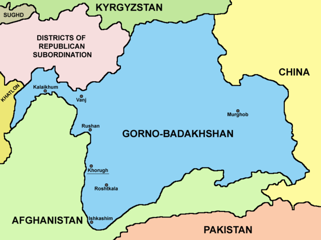
English: Map of Gorno-Badakhshan. |
| Сана | |
| Манбаъ | Кори худ |
| Муаллиф | PANONIAN |
Иҷозатнома
I, the copyright holder of this work, hereby publish it under the following license:
| This file is made available under the Creative Commons CC0 1.0 Universal Public Domain Dedication. | |
| The person who associated a work with this deed has dedicated the work to the public domain by waiving all of their rights to the work worldwide under copyright law, including all related and neighboring rights, to the extent allowed by law. You can copy, modify, distribute and perform the work, even for commercial purposes, all without asking permission.
|
Таърихи файл
Рӯи таърихҳо клик кунед то нусхаи марбути парвандаро бубинед.
| Таърих | Бандангуштӣ | Андоза | Корбар | Тавзеҳ | |
|---|---|---|---|---|---|
| нусхаи феълӣ | 21:15, 9 августи 2023 | | 948 × 709 (20 кбайт) | Lojwe | Cropped 2 % horizontally, 5 % vertically using CropTool with precise mode. |
| 04:08, 27 сентябри 2021 |  | 970 × 749 (57 кбайт) | GPinkerton | Reverted to version as of 09:58, 14 May 2013 (UTC) COM:CROP | |
| 17:25, 4 апрели 2021 |  | 970 × 749 (47 кбайт) | Claude Zygiel | Differenciate international boundaries (black) from administrative of Tadjikistan (grey) | |
| 09:58, 14 май 2013 |  | 970 × 749 (57 кбайт) | PANONIAN | {{Information |Description ={{en|1=Map of Gorno-Badakhshan.}} |Source ={{own}} |Author =PANONIAN |Date =2013 |Permission = |other_versions = }} |
Пайвандҳо
Саҳифаҳои зерин ба ин акс пайванданд:
Истифодаи саросарии парванда
Викиҳои дигари зерин ин файлро истифода мекунанд:
- Истифода дар be.wikipedia.org
- Истифода дар bg.wikipedia.org
- Истифода дар cs.wikipedia.org
- Истифода дар el.wikipedia.org
- Истифода дар en.wikipedia.org
- Истифода дар eo.wikipedia.org
- Истифода дар es.wikipedia.org
- Истифода дар et.wikipedia.org
- Истифода дар fa.wikipedia.org
- Истифода дар fi.wikipedia.org
- Истифода дар fr.wikipedia.org
- Истифода дар gl.wikipedia.org
- Истифода дар hi.wikipedia.org
- Истифода дар id.wikipedia.org
- Истифода дар incubator.wikimedia.org
- Истифода дар it.wikipedia.org
- Истифода дар kaa.wikipedia.org
- Истифода дар ko.wikipedia.org
- Истифода дар lt.wikipedia.org
- Истифода дар pl.wikipedia.org
- Истифода дар pnb.wikipedia.org
- Истифода дар ps.wikipedia.org
- Истифода дар pt.wikipedia.org
- Истифода дар sr.wikipedia.org
- Истифода дар sv.wikipedia.org
- Истифода дар ta.wikipedia.org
- Истифода дар tr.wikipedia.org
- Истифода дар ur.wikipedia.org
- Истифода дар uz.wikipedia.org
- Истифода дар vi.wikipedia.org
- Истифода дар xmf.wikipedia.org
- Истифода дар zh.wikipedia.org