
Акс:Hawaii Island topographic map-fr.svg

Ҳаҷми пешнамоиши PNG барои файли кунунии SVG: 728 × 600 пиксел. Дигар кайфиятҳо: 291 × 240 пиксел | 583 × 480 пиксел | 932 × 768 пиксел | 1 243 × 1 024 пиксел | 2 485 × 2 048 пиксел | 3 110 × 2 563 пиксел.
Акси аслӣ (SVG парванда, исмӣ 3 110 × 2 563 пиксел, андозаи парванда: 2,11 Мбайт)
Хулоса
| Description | |||||||||
| Сана | |||||||||
| Манбаъ |
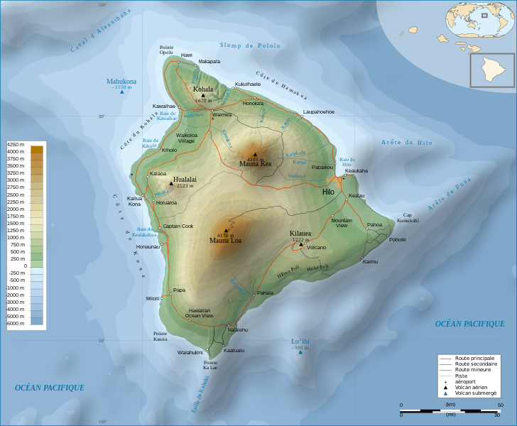
Français : Travail personnel.
Sources :
Logiciels utilisés :
Autres données :
English: Personal work.
Sources:
Software used:
Other Details:
|
||||||||
| Падидоваранда | |||||||||
| Georeferencing | If inappropriate please set warp_status = skip to hide. | ||||||||
| Other versions | |||||||||
| Тахсис (required by the license) | © Sémhur / Wikimedia Commons / | ||||||||
| Assessments |
|
||||||||
| SVG | W3C-validity not checked.
|
||||||||
| Graphic Lab |


| Camera location | | View this and other nearby images on: OpenStreetMap |
|---|
Иҷозатнома
I, the copyright holder of this work, hereby publish it under the following licenses:
| Copyleft: This work of art is free; you can redistribute it and/or modify it according to terms of the Free Art License. You will find a specimen of this license on the Copyleft Attitude site as well as on other sites. |
This file is licensed under the Creative Commons Attribution-Share Alike 4.0 International, 3.0 Unported, 2.5 Generic, 2.0 Generic and 1.0 Generic license.
- Шумо озодед:
- мубодилот намудан – копӣ, паҳн ва фиристадани асар
- ремикс кардан – татбиқи кор
- Under the following conditions:
- тахсис – You must give appropriate credit, provide a link to the license, and indicate if changes were made. You may do so in any reasonable manner, but not in any way that suggests the licensor endorses you or your use.
- саҳми яксон – If you remix, transform, or build upon the material, you must distribute your contributions under the same or compatible license as the original.
Шумо иҷозатномаи хостаи худро интихоб карда метавонед.
Таърихи файл
Рӯи таърихҳо клик кунед то нусхаи марбути парвандаро бубинед.
| Таърих | Бандангуштӣ | Андоза | Корбар | Тавзеҳ | |
|---|---|---|---|---|---|
| нусхаи феълӣ | 12:24, 16 феврали 2009 | | 3 110 × 2 563 (2,11 Мбайт) | Sémhur | Valid SVG |
| 17:31, 7 май 2008 |  | 3 110 × 2 563 (2,19 Мбайт) | Sémhur | Route coupée trop courte, je rallonge. | |
| 17:57, 2 май 2008 |  | 3 110 × 2 563 (2,18 Мбайт) | Sémhur | Suppression d'une partie d'une route détruite par une coulée de lave | |
| 10:37, 1 май 2008 |  | 3 110 × 2 563 (2,18 Мбайт) | Sémhur | New version, with vectorized shaded relief | |
| 18:35, 29 апрели 2008 |  | 3 110 × 2 563 (1 017 кбайт) | Sting | Slight correction | |
| 18:11, 29 апрели 2008 |  | 3 110 × 2 563 (1 017 кбайт) | Sting | Added legend | |
| 16:01, 22 апрели 2008 |  | 3 110 × 2 563 (1 012 кбайт) | Sémhur | Espacement de lettres (oubli) | |
| 08:45, 19 апрели 2008 |  | 3 110 × 2 563 (1 011 кбайт) | Sémhur | Correction de l'altitude du Mauna Loa et espacement de lettres | |
| 19:04, 17 апрели 2008 |  | 3 110 × 2 563 (995 кбайт) | Sémhur | Correction d'un problème avec le relief | |
| 18:47, 17 апрели 2008 |  | 3 110 × 2 563 (996 кбайт) | Sémhur | == Description == {{Information |Description= {{en| Topographic Map in french of the island of Hawaii.}} {{fr| Carte topographique de l'île de Hawaii.}} |Source=Travail personnel. {{clr}} Sources : * Fond de carte : |
Пайвандҳо
Саҳифаҳои зерин ба ин акс пайванданд:
Истифодаи саросарии парванда
Викиҳои дигари зерин ин файлро истифода мекунанд:
- Истифода дар af.wikipedia.org
- Истифода дар ar.wikipedia.org
- Истифода дар bn.wikipedia.org
- Истифода дар crh.wikipedia.org
- Истифода дар cv.wikipedia.org
- Истифода дар en.wikipedia.org
- Истифода дар eo.wikipedia.org
- Истифода дар es.wikipedia.org
- Истифода дар eu.wikipedia.org
- Истифода дар fr.wikipedia.org
- Analogique
- Mauna Kea
- Mauna Loa
- Utilisateur:Sémhur
- Hawaï (île)
- Hualālai
- Discussion aide:Cartographie
- Discussion Wikipédia:Wikiconcours/mars 2008/Équipes/Équipe 5
- Projet:Impression/Wikigraphistes
- Utilisateur:Sémhur/Récompenses
- Wikipédia:Image du jour/juin 2010
- Wikipédia:Image du jour/16 juin 2010
- Kohala (volcan)
- Cap Kumukahi
- Phare du cap Kumukahi
- Discussion Wikipédia:Atelier graphique/Archive 10
- Истифода дар fr.wikinews.org
- Истифода дар hu.wikipedia.org
- Истифода дар id.wikipedia.org
- Истифода дар it.wikipedia.org
- Истифода дар ko.wikipedia.org
- Истифода дар krc.wikipedia.org
- Истифода дар lbe.wikipedia.org
- Истифода дар lv.wikipedia.org
- Истифода дар mg.wikipedia.org
- Истифода дар mk.wikipedia.org
- Истифода дар mt.wikipedia.org
View more global usage of this file.