Акс:India (orthographic projection).svg
Page contents not supported in other languages.
Мавод аз Википедиа — донишномаи озод

Акси аслӣ(SVG парванда, исмӣ 541 × 541 пиксел, андозаи парванда: 280 кбайт)

Ин файл аз Викианбор ва дар дигар лоиҳаҳо метавонад истифода шавад. Тафсилоти ин файл саҳифаи тафсилоти файл дар зер нишон дода шудааст.

Хулоса

Тавсифот
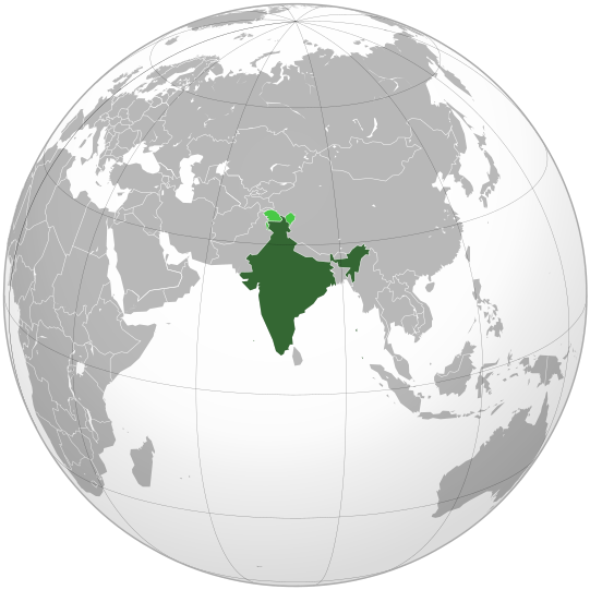
English: India. Area controlled by India in dark green; claimed but not controlled areas in light green.
Сана
Манбаъ

Own work,

 
This vector image was created with Inkscape .

Aquarius.geomar.de

বাংলা  English  español  français  italiano  日本語  македонски  sicilianu  中文(简体)  中文(繁體)  +/−

GNU head Permission is granted to copy, distribute and/or modify this document under the terms of the GNU Free Documentation License, Version 1.2 or any later version published by the Free Software Foundation; with no Invariant Sections, no Front-Cover Texts, and no Back-Cover Texts. A copy of the license is included in the section entitled GNU Free Documentation License.
Муаллиф Ssolbergj (talk)
Other versions

Derivative works of this file:

This is a Grey & green orthographic projection map.
العربية: الرجاء، قراءة الميثاق.
বাংলা: দয়া করে, রীতিনীতিটি পড়ুন
Deutsch: Bitte lies die Konventionen.
English: Please, read the conventions.
Español: Por favor, lea las convenciones.
Filipino: Paki-basa ang mga kumbensyon.
Français : S'il vous plaît, lisez les conventions.
हिन्दी: कृपया सभागमों को पढ़ लें.
Bahasa Indonesia: Silakan, baca konvensi.
Italiano: Si prega di leggere le convenzioni.
ქართული: გთხოვთ, გაეცნოთ კონვენციებს.
Português: Por favor, leia as convenções.
Русский: Пожалуйста, прочитайте соглашения.
Українська: Будь ласка, прочитайте конвенції.
Tiếng Việt: Hãy đọc công văn trước khi đăng.
World maps

Africa

हिन्दी: अफ्रीका
ქართული: აფრიკა.

Eastern Africa

Southern Africa

Central Africa

Northern Africa

Western Africa

Americas

ქართული: ამერიკა.
हिन्दी: अमेरिका

North America

Central America

Caribbean

South America

Asia

ქართული: აზია.
Português: Ásia.
Українська: Азія.

East

Português: Ásia Oriental.
Українська: Східна Азія.

Central

हिन्दी: मध्य एशिया
Português: Ásia Central.
Українська: Центральна Азія.

Southeast

Bahasa Indonesia: Asia tenggara
Português: Sudeste Asiático.

South

(भारतीय उपमहाद्वीप)
Português: Sul da Ásia.
Українська: Південна Азія.

Western

Português: Sudoeste da Ásia.
Українська: Передня Азія.

Europe

हिन्दी: यूरोप
ქართული: ევროპა.
Português: Europa.
Română: Europa.
Русский: Европа.
Українська: Європа.

Countries

Oceania

हिन्दी: ओशिआनिया
ქართული: ოკეანეთი.
Português: Oceania.
Українська: Океанія.

Intercontinental

Português: Intercontinental.
Українська: Міжконтинентальні.

Historical

English: Unions, Organizations, Kingdoms, Empires
Español: Uniones, Organizaciones, Reinos, Imperios
Filipino: Mga Unyon, Organisasyon, Kaharian, Imperyo
Français : Unions, Organisations, Royaumes, Empires
हिन्दी: संघ, संगठन, राज्य, साम्राज्य व ऐतिहासिक देश
ქართული: გაერთიანებები, ორგანიზაციები, სამეფოები, იმპერიები
Português: Estados extintos.
Tagalog: Mga Unyon, Organisasyon, Kaharian, Imperyo
Українська: Союзи, Організації, Королівства, Імперії

Subnationals

हिन्दी: उपराष्ट्रीय इकाईयाँ
Orthographic projections maps created by Ssolbergj
Orthographic projections maps created by Ssolbergj:

Иҷозатнома

I, the copyright holder of this work, hereby publish it under the following licenses:
GNU head Permission is granted to copy, distribute and/or modify this document under the terms of the GNU Free Documentation License, Version 1.2 or any later version published by the Free Software Foundation; with no Invariant Sections, no Front-Cover Texts, and no Back-Cover Texts. A copy of the license is included in the section entitled GNU Free Documentation License.
w:en:Creative Commons
тахсис саҳми яксон
This file is licensed under the Creative Commons Attribution-Share Alike 3.0 Unported license.
Шумо озодед:
  • мубодилот намудан – копӣ, паҳн ва фиристадани асар
  • ремикс кардан – татбиқи кор
Under the following conditions:
  • тахсис – You must give appropriate credit, provide a link to the license, and indicate if changes were made. You may do so in any reasonable manner, but not in any way that suggests the licensor endorses you or your use.
  • саҳми яксон – If you remix, transform, or build upon the material, you must distribute your contributions under the same or compatible license as the original.
Шумо иҷозатномаи хостаи худро интихоб карда метавонед.
{{{template}}} Warning! According to Indian law, it is illegal to produce maps that in the view of the Indian government, misrepresent Indian territories by showing areas the Indian government claims ownership of but does not control as not belonging to India or as being contested.

Captions

Add a one-line explanation of what this file represents
india

Items portrayed in this file

тавсифҳо

MIME type Англисӣ

image/svg+xml

Таърихи файл

Рӯи таърихҳо клик кунед то нусхаи марбути парвандаро бубинед.

(Охирин | Аввалин) Намоиш (10-тои навтар) () (10 | 20 | 50 | 100 | 250 | 500)
ТаърихБандангуштӣАндозаКорбарТавзеҳ
нусхаи феълӣ07:10, 26 апрели 2023Акси бандангуштӣ аз нусхаи то 07:10, 26 апрели 2023541 × 541 (280 кбайт)Swtadi143Reverted to version as of 07:34, 16 September 2021 (UTC) siachen glacier is fully controlled by india and not india pakistan jointly, see Siachen conflict for context.
10:02, 20 сентябри 2021Акси бандангуштӣ аз нусхаи то 10:02, 20 сентябри 2021512 × 512 (155 кбайт)Ytpks896Reverted to version as of 17:38, 6 September 2021 (UTC) Siachen is a disputed territory not fully controlled by single country it is controlled by both Pakistan and india & some parts by china
07:34, 16 сентябри 2021Акси бандангуштӣ аз нусхаи то 07:34, 16 сентябри 2021541 × 541 (280 кбайт)Ksh.andronexusReverted to version as of 16:08, 19 December 2019 (UTC)
17:38, 6 сентябри 2021Акси бандангуштӣ аз нусхаи то 17:38, 6 сентябри 2021512 × 512 (155 кбайт)MilenioscuroSiachen is a disputed territory between China, India and Pakistan
16:08, 19 Декабри 2019Акси бандангуштӣ аз нусхаи то 16:08, 19 Декабри 2019541 × 541 (280 кбайт)Goran tek-enAdded border for South Sudan as requested by {{u|Maphobbyist}}
14:04, 21 октябри 2017Акси бандангуштӣ аз нусхаи то 14:04, 21 октябри 2017541 × 541 (139 кбайт)Goran tek-enAdded Siachen Glacier as requested by {{u|King Prithviraj II}}
21:31, 12 сентябри 2012Акси бандангуштӣ аз нусхаи то 21:31, 12 сентябри 2012541 × 541 (167 кбайт)PalosirkkaScrubbed with http://codedread.com/scour/
23:40, 15 ноябри 2009Акси бандангуштӣ аз нусхаи то 23:40, 15 ноябри 2009541 × 541 (573 кбайт)Shibo77+Eritrea, Yemen; -neutral zone
13:18, 1 ноябри 2009Акси бандангуштӣ аз нусхаи то 13:18, 1 ноябри 2009541 × 541 (496 кбайт)Pahari SahibMap showing territory governered by India, see map of Pakistan
13:17, 11 марти 2009Акси бандангуштӣ аз нусхаи то 13:17, 11 марти 2009541 × 541 (572 кбайт)TryphonReverted to version as of 22:12, 13 February 2009: please use the talk page before reverting this image; there are apparently many people who want the map this way.
(Охирин | Аввалин) Намоиш (10-тои навтар) () (10 | 20 | 50 | 100 | 250 | 500)

Саҳифаҳои зерин ба ин акс пайванданд:

Истифодаи саросарии парванда

Викиҳои дигари зерин ин файлро истифода мекунанд:

View more global usage of this file.

Метадода