
Акс:India disputed areas map.svg

Акси аслӣ (SVG парванда, исмӣ 1 639 × 1 852 пиксел, андозаи парванда: 978 кбайт)
Хулоса
| Унвони мақола |
India map disputed areas |
| Description |
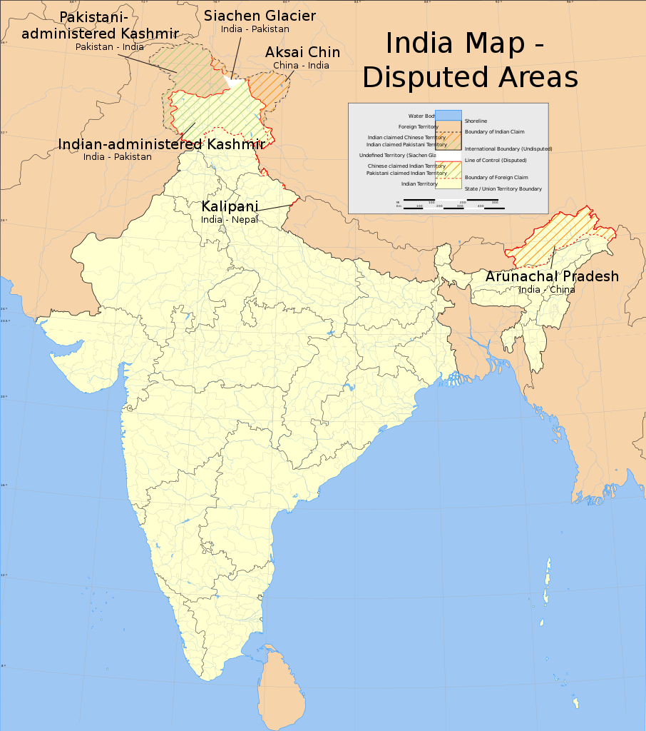
English: Map showing disputed areas of India. See also File:India Pakistan China Disputed Areas Map.png. |
| Map legend |
 |
| Сана | |
| Манбаъ |
Кори худ |
| Падидоваранда | |
| Иҷозат (Пешроҳандозии ин парванда) |
|
| Geotemporal data | |
| Date depicted | second half of 20 century ва 21 century |
| Spatial reference system | conic |
| Georeferencing | If inappropriate please set warp_status = skip to hide. |
| Archival data | |
| Эзоҳот | Part of WikiProject India Maps |
| SVG genesis | This W3C-invalid map was created with Adobe Illustrator. |
Notes
Depiction of India's borders
- The territorial boundaries of India are shown as per the actual ground situation in accordance with international practices followed by the United Nations ([1], [2]) and the National Geographic Society ([3], [4])
- This map is meant to be for illustrative purpose only and is not authenticated by official government sources. Please check the list of sources and references used to create the map for a measure of accuracy and verifiability.
- The usage of these maps in India, Pakistan and China are governed by different laws that restrict depictions of boundaries other than what is officially recognized by the state. Please check local laws and modify the map accordingly before use.
Explanation of disputed boundaries


- Boundary of Indian claim : The territory India claims is legally theirs, but the claim is disputed by China and Pakistan.
- Line of Control/Line of Conflict : The de facto administrative boundary recognised by the international community. This UN ceasefire line is considered as a temporary solution to an ongoing conflict since the departure of the British Raj.
Borders of disputed regions
The depicted extent of the former territory of the British Indian Empire, succeeded by Republic of India, may not be accepted by few countries as legal due to ongoing border disputes:
- The northern Himalayan region of the disputed territory Indian-administered Kashmir is claimed by India including (Pakistan-administered Kashmir) and the Chinese-occupied territory of (Ladakh plateau). Since 1972, it is divided between all three countries. See also Line of Control and Line of Actual Control.
- Siachen glacier (shown white) is an actively contested region between India and Pakistan. Since 1984, the region is under Indian control.
- The northeastern territory of Arunachal Pradesh is almost entirely claimed by China as part of its Tibetan territory.
- Minor areas of eastern Kashmir's Ladakh division, Himachal Pradesh and Uttarakhand on the Chinese frontier are claimed by China. These areas are under Indian control.
- A small area of Uttarakhand adjoining the Nepal border along the Sarda river is disputed between the two countries.
For a detailed map of all disputed regions in South Asia, see Image:India disputed areas map.svg
Internal borders
The borders of the state of Meghalaya, Assam and Arunachal Pradesh are shown as interpreted from the North-Eastern Areas (Reorganisation) Act, 1971, but has yet to be verified.
Territorial waters
The limit of the territorial waters of India extends to twelve nautical miles measured from the appropriate baseline. See this for more information.
Иҷозатнома
- Шумо озодед:
- мубодилот намудан – копӣ, паҳн ва фиристадани асар
- ремикс кардан – татбиқи кор
- Under the following conditions:
- тахсис – You must give appropriate credit, provide a link to the license, and indicate if changes were made. You may do so in any reasonable manner, but not in any way that suggests the licensor endorses you or your use.
- саҳми яксон – If you remix, transform, or build upon the material, you must distribute your contributions under the same or compatible license as the original.
Таърихи файл
Рӯи таърихҳо клик кунед то нусхаи марбути парвандаро бубинед.
| Таърих | Бандангуштӣ | Андоза | Корбар | Тавзеҳ | |
|---|---|---|---|---|---|
| нусхаи феълӣ | 11:51, 10 июни 2020 | | 1 639 × 1 852 (978 кбайт) | Uanfala | Quickly change the wording in Kashmir for neutrality and consistency |
| 12:55, 31 июли 2006 |  | 1 639 × 1 852 (978 кбайт) | Planemad | {{WikiProject_India_Maps |Title=India map disputed areas |Description=Map showing disputed areas of India. |Source=. |Date=July 31 2006 |Author=w:user:Planemad |Thumbdir=a/ab }} |
Пайвандҳо
Ин акс дар ҳеҷ саҳифа истифода намешавад.
Истифодаи саросарии парванда
Викиҳои дигари зерин ин файлро истифода мекунанд:
- Истифода дар en.wikipedia.org
- Истифода дар es.wikipedia.org
- Истифода дар fi.wikipedia.org
- Истифода дар fr.wikipedia.org
- Истифода дар ja.wikipedia.org
- Истифода дар kn.wikipedia.org
- Истифода дар ml.wikipedia.org
- Истифода дар mr.wikipedia.org
- Истифода дар or.wikipedia.org
- Истифода дар pa.wikipedia.org
- Истифода дар pnb.wikipedia.org
- Истифода дар ru.wikinews.org
- Истифода дар sh.wikipedia.org
- Истифода дар sr.wikipedia.org
- Истифода дар sv.wikipedia.org
- Истифода дар ta.wikipedia.org
- Истифода дар te.wikipedia.org
- Истифода дар ur.wikipedia.org
- Истифода дар vi.wikipedia.org
- Истифода дар www.wikidata.org
- Истифода дар zh.wikipedia.org