
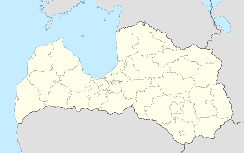
Акс:Latvia location map.svg

Ҳаҷми пешнамоиши PNG барои файли кунунии SVG: 800 × 504 пиксел. Дигар кайфиятҳо: 320 × 201 пиксел | 640 × 403 пиксел | 1 024 × 645 пиксел | 1 280 × 806 пиксел | 2 560 × 1 612 пиксел | 1 304 × 821 пиксел.
Акси аслӣ (SVG парванда, исмӣ 1 304 × 821 пиксел, андозаи парванда: 139 кбайт)
Хулоса
| Тавсифот |
Deutsch: Positionskarte von Lettland
Quadratische Plattkarte, N-S-Streckung 170 %. Geographische Begrenzung der Karte:
English: Location map of Latvia
Equirectangular projection, N/S stretching 170 %. Geographic limits of the map:
Latviešu: Latvijas novadu karte
Vienādintervāla projekcija, Z/D izstiepšana 170 %. Kartes ģeogrāfiskās robežas:
|
| Сана | |
| Манбаъ | own work, using United States National Imagery and Mapping Agency data |
| Муаллиф | NordNordWest |
| Other versions |
Derivative works of this file: Relief Map of Latvia.jpg
|


|
This map has been made or improved in the German Kartenwerkstatt (Map Lab). You can propose maps to improve as well.
|
Иҷозатнома
I, the copyright holder of this work, hereby publish it under the following licenses:

|
Permission is granted to copy, distribute and/or modify this document under the terms of the GNU Free Documentation License, Version 1.2 or any later version published by the Free Software Foundation; with no Invariant Sections, no Front-Cover Texts, and no Back-Cover Texts. A copy of the license is included in the section entitled GNU Free Documentation License. |
This file is licensed under the Creative Commons Attribution-Share Alike 3.0 Unported license.
- Шумо озодед:
- мубодилот намудан – копӣ, паҳн ва фиристадани асар
- ремикс кардан – татбиқи кор
- Under the following conditions:
- тахсис – You must give appropriate credit, provide a link to the license, and indicate if changes were made. You may do so in any reasonable manner, but not in any way that suggests the licensor endorses you or your use.
- саҳми яксон – If you remix, transform, or build upon the material, you must distribute your contributions under the same or compatible license as the original.
Шумо иҷозатномаи хостаи худро интихоб карда метавонед.
Таърихи файл
Рӯи таърихҳо клик кунед то нусхаи марбути парвандаро бубинед.
| Таърих | Бандангуштӣ | Андоза | Корбар | Тавзеҳ | |
|---|---|---|---|---|---|
| нусхаи феълӣ | 16:38, 10 июли 2021 | | 1 304 × 821 (139 кбайт) | Obivan Kenobi | New boundaries from July 1st 2021 |
| 11:07, 5 май 2017 |  | 1 304 × 821 (170 кбайт) | NordNordWest | Reverted to version as of 08:15, 5 May 2017 (UTC); you may find your way to the file discussion page _before_ changing this map | |
| 08:51, 5 май 2017 |  | 1 305 × 822 (316 кбайт) | Намѣсникъ | Reverted to version as of 02:37, 5 May 2017 (UTC) | |
| 08:15, 5 май 2017 |  | 1 304 × 821 (170 кбайт) | NordNordWest | sorry, no, the colours are standardized but the lines can be thinner | |
| 02:37, 5 май 2017 |  | 1 305 × 822 (316 кбайт) | Намѣсникъ | lighter adm. boundaries for Location maps in templates | |
| 12:34, 2 октябри 2012 |  | 1 304 × 821 (177 кбайт) | Palosirkka | Reverted to version as of 16:22, 15 June 2012 Location maps must remain very accurate | |
| 20:56, 1 октябри 2012 |  | 1 304 × 821 (167 кбайт) | Palosirkka | Scrubbed with http://codedread.com/scour/ | |
| 16:22, 15 июни 2012 |  | 1 304 × 821 (177 кбайт) | NordNordWest | c | |
| 09:42, 15 августи 2011 |  | 1 304 × 821 (176 кбайт) | NordNordWest | corr | |
| 13:16, 4 июли 2009 |  | 1 305 × 822 (359 кбайт) | Glossologist | from July 1 the political map of Latvia is like that |
Пайвандҳо
Ин акс дар ҳеҷ саҳифа истифода намешавад.
Истифодаи саросарии парванда
Викиҳои дигари зерин ин файлро истифода мекунанд:
- Истифода дар af.wikipedia.org
- Истифода дар an.wikipedia.org
- Истифода дар ast.wikipedia.org
- Истифода дар azb.wikipedia.org
- Истифода дар be-tarask.wikipedia.org
- Истифода дар bn.wikipedia.org
- Истифода дар bs.wikipedia.org
- Истифода дар ckb.wikipedia.org
- Истифода дар de.wikipedia.org
- Истифода дар de.wikivoyage.org
- Истифода дар en.wikipedia.org
- Истифода дар eo.wikivoyage.org
- Истифода дар es.wikipedia.org
- Riga
- Liepāja
- Ventspils
- Rēzekne
- Jūrmala
- Aeropuerto Internacional de Riga
- Jelgava
- Jardín botánico de la Universidad de Letonia
- Jardín botánico nacional de Letonia
- Ikšķile
- Aeropuerto Internacional de Liepāja
- Aeropuerto Internacional de Ventspils
- Valmiera
- Jēkabpils
- Municipio de Mālpils
- Aizkraukle
- Aizpute
- Aknīste
- Alsunga
- Alūksne
- Baldone
- Balvi
- Bauska
View more global usage of this file.