
Акс:NWFP FATA.svg

Ҳаҷми пешнамоиши PNG барои файли кунунии SVG: 558 × 600 пиксел. Дигар кайфиятҳо: 223 × 240 пиксел | 446 × 480 пиксел | 714 × 768 пиксел | 953 × 1 024 пиксел | 1 905 × 2 048 пиксел | 1 000 × 1 075 пиксел.
Акси аслӣ (SVG парванда, исмӣ 1 000 × 1 075 пиксел, андозаи парванда: 171 кбайт)
Хулоса
| Тавсифот |
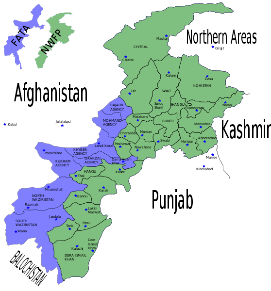
English: Map showing the districts of the Federally Administered Tribal Areas (FATA) and the North-West Frontier Province (NWFP) of Pakistan. |
| Сана | |
| Манбаъ | Self made using Inkscape - Based on maps from http://www.nwfp.gov.pk |
| Муаллиф | Pahari Sahib |
| Other versions | Derivative works of this file: Pakistan NWFP FATA areas with localisation map.svg |
Иҷозатнома
I, the copyright holder of this work, hereby publish it under the following licenses:

|
Permission is granted to copy, distribute and/or modify this document under the terms of the GNU Free Documentation License, Version 1.2 or any later version published by the Free Software Foundation; with no Invariant Sections, no Front-Cover Texts, and no Back-Cover Texts. A copy of the license is included in the section entitled GNU Free Documentation License. |
| This file is licensed under the Creative Commons Attribution-Share Alike 3.0 Unported license. | ||
| ||
| This licensing tag was added to this file as part of the GFDL licensing update. |
This file is licensed under the Creative Commons Attribution-Share Alike 2.5 Generic, 2.0 Generic and 1.0 Generic license.
- Шумо озодед:
- мубодилот намудан – копӣ, паҳн ва фиристадани асар
- ремикс кардан – татбиқи кор
- Under the following conditions:
- тахсис – You must give appropriate credit, provide a link to the license, and indicate if changes were made. You may do so in any reasonable manner, but not in any way that suggests the licensor endorses you or your use.
- саҳми яксон – If you remix, transform, or build upon the material, you must distribute your contributions under the same or compatible license as the original.
Шумо иҷозатномаи хостаи худро интихоб карда метавонед.
Таърихи файл
Рӯи таърихҳо клик кунед то нусхаи марбути парвандаро бубинед.
| Таърих | Бандангуштӣ | Андоза | Корбар | Тавзеҳ | |
|---|---|---|---|---|---|
| нусхаи феълӣ | 11:04, 11 августи 2015 | | 1 000 × 1 075 (171 кбайт) | Colajmal | issue with format |
| 11:03, 11 августи 2015 |  | 1 000 × 1 120 (66 кбайт) | Colajmal | Map of KPK & FATA with ethnic breakdown | |
| 21:31, 6 июни 2007 |  | 1 000 × 1 075 (171 кбайт) | Pahari Sahib | {{Information |Description=Map showing the districts of the Federally Administered Tribal Areas (FATA) FATA and the North-West Frontier Province (NWFP) of Pakistan. |Source= Self made using Inkscapte - Based on maps from http://www.nwfp.gov.pk |Date=0 |
Пайвандҳо
Саҳифаҳои зерин ба ин акс пайванданд:
Истифодаи саросарии парванда
Викиҳои дигари зерин ин файлро истифода мекунанд:
- Истифода дар ar.wikipedia.org
- Истифода дар azb.wikipedia.org
- Истифода дар be-tarask.wikipedia.org
- Истифода дар be.wikipedia.org
- Истифода дар ca.wikipedia.org
- Истифода дар cy.wikipedia.org
- Истифода дар da.wikipedia.org
- Истифода дар en.wikipedia.org
- Military history of the North-West Frontier
- Hazara District
- Insurgency in Khyber Pakhtunkhwa
- User:AlexNebraska/Images of Pakistan
- 2008 Orakzai bombing
- 2009 Pakistan Army Mil Mi-17 crash
- Operation Sirat-e-Mustaqeem
- Babur's First Indian Expedition
- Qabailistan
- Twenty-fifth Amendment to the Constitution of Pakistan
- User:Falcaorib
- Истифода дар en.wikinews.org
- Истифода дар eo.wikipedia.org
- Истифода дар es.wikipedia.org
- Истифода дар fa.wikipedia.org
- Истифода дар fi.wikipedia.org
- Истифода дар fr.wikipedia.org
- Истифода дар hi.wikipedia.org
- Истифода дар hu.wikipedia.org
- Истифода дар hy.wikipedia.org
- Истифода дар id.wikipedia.org
- Истифода дар it.wikipedia.org
- Истифода дар ja.wikipedia.org
- Истифода дар ko.wikipedia.org
- Истифода дар ms.wikipedia.org
- Истифода дар new.wikipedia.org
- Истифода дар nl.wikipedia.org
- Истифода дар no.wikipedia.org
- Истифода дар pa.wikipedia.org
- Истифода дар pl.wikipedia.org
View more global usage of this file.