
Акс:New York state geographic map-en.svg

Ҳаҷми пешнамоиши PNG барои файли кунунии SVG: 800 × 569 пиксел. Дигар кайфиятҳо: 320 × 228 пиксел | 640 × 455 пиксел | 1 024 × 729 пиксел | 1 280 × 911 пиксел | 2 560 × 1 821 пиксел | 2 811 × 2 000 пиксел.
Акси аслӣ (SVG парванда, исмӣ 2 811 × 2 000 пиксел, андозаи парванда: 18,34 Мбайт)
Хулоса
| Description |
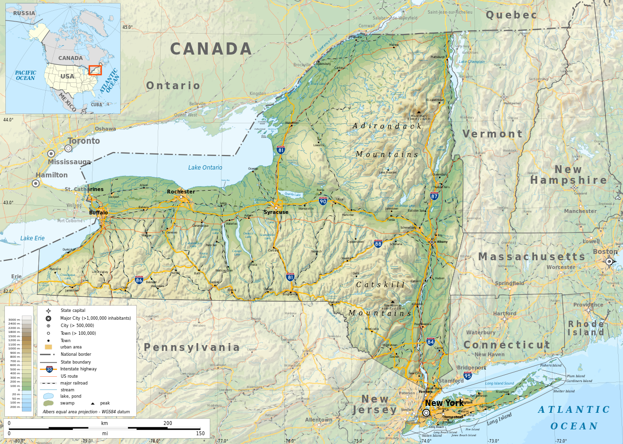
English: Geographic map of New York state in English. Geographic limits of the map:
|
| Сана | |
| Манбаъ |
Кори худ
|
| Падидоваранда | |
| Иҷозат (Пешроҳандозии ин парванда) |
Any use of this map is subject of the license(s) stated below with the condition that you credit (Wikimedia Commons user: Ikonact) as the author . A message with a reply address would also be greatly appreciated. |
| Georeferencing | If inappropriate please set warp_status = skip to hide. |
|

|
This SVG file contains embedded text that can be translated into your language, using any capable SVG editor, text editor or the SVG Translate tool. For more information see: About translating SVG files. |
Иҷозатнома
| This work contains information from OpenStreetMap, which is made available under the Open Database License (ODbL).
The ODbL does not require any particular license for maps produced from ODbL data. Prior to 1 August 2020, map tiles produced by the OpenStreetMap Foundation were licensed under the CC-BY-SA-2.0 license. Maps produced by other people may be subject to other licences. |
I, the copyright holder of this work, hereby publish it under the following license:
This file is licensed under the Creative Commons Attribution-Share Alike 4.0 International license.
- Шумо озодед:
- мубодилот намудан – копӣ, паҳн ва фиристадани асар
- ремикс кардан – татбиқи кор
- Under the following conditions:
- тахсис – You must give appropriate credit, provide a link to the license, and indicate if changes were made. You may do so in any reasonable manner, but not in any way that suggests the licensor endorses you or your use.
- саҳми яксон – If you remix, transform, or build upon the material, you must distribute your contributions under the same or compatible license as the original.
Таърихи файл
Рӯи таърихҳо клик кунед то нусхаи марбути парвандаро бубинед.
| Таърих | Бандангуштӣ | Андоза | Корбар | Тавзеҳ | |
|---|---|---|---|---|---|
| нусхаи феълӣ | 12:15, 2 ноябри 2023 | | 2 811 × 2 000 (18,34 Мбайт) | Ikonact | corrected some typos in names // Editing SVG source code using c:User:Rillke/SVGedit.js |
| 10:22, 14 октябри 2019 |  | 2 811 × 2 000 (18,41 Мбайт) | Ikonact | better dealing with fall back font | |
| 21:19, 12 октябри 2019 |  | 2 811 × 2 000 (20,53 Мбайт) | Ikonact | + fall back font, more towns and islands, provinces | |
| 23:33, 11 октябри 2019 |  | 2 811 × 2 000 (20,47 Мбайт) | Ikonact | error corrected | |
| 23:23, 11 октябри 2019 |  | 2 811 × 2 000 (20,47 Мбайт) | Ikonact | river and lake names added | |
| 21:58, 8 октябри 2019 |  | 2 811 × 2 000 (20,33 Мбайт) | Ikonact | some improvements, roads and cities in Canada | |
| 07:40, 22 сентябри 2019 |  | 2 811 × 2 000 (14,39 Мбайт) | Ikonact | small corrections | |
| 20:49, 21 сентябри 2019 |  | 2 811 × 2 000 (14,39 Мбайт) | Ikonact | + road names | |
| 20:23, 21 сентябри 2019 |  | 2 811 × 2 000 (14,31 Мбайт) | Ikonact | +names | |
| 22:01, 20 сентябри 2019 |  | 2 811 × 2 000 (15,37 Мбайт) | Ikonact | == {{int:filedesc}} == {{Information |description={{en|1=Geographic map of New York state in English. Geographic limits of the map:}} *N: 45.30° N *S: 40.30° N *W: 80.20° W *E: 71.00° W Albers equal area projection; WGS 84 datum |date=2019-09-21 |source={{own}} *Sources of data:<br/> **Topography: ETOPO1 (public domain);<br/> **Public domain data provided by the National Atlas of the United States of America;<br/> *Tool:<br/> **The map is created with Octave scripts d... |
Пайвандҳо
Саҳифаҳои зерин ба ин акс пайванданд:
Истифодаи саросарии парванда
Викиҳои дигари зерин ин файлро истифода мекунанд:
- Истифода дар af.wikipedia.org
- Истифода дар ang.wikipedia.org
- Истифода дар az.wikipedia.org
- Истифода дар be.wikipedia.org
- Истифода дар bg.wikipedia.org
- Истифода дар bn.wikipedia.org
- Истифода дар ca.wikipedia.org
- Истифода дар en.wikipedia.org
- Истифода дар eo.wikipedia.org
- Истифода дар fr.wikipedia.org
- Истифода дар ga.wikipedia.org
- Истифода дар gl.wikipedia.org
- Истифода дар ha.wikipedia.org
- Истифода дар hu.wikipedia.org
- Истифода дар hy.wikipedia.org
- Истифода дар id.wikipedia.org
- Истифода дар lt.wikipedia.org
- Истифода дар mhr.wikipedia.org
- Истифода дар ml.wikipedia.org
- Истифода дар os.wikipedia.org
- Истифода дар pcd.wikipedia.org
- Истифода дар pl.wikipedia.org
- Истифода дар sh.wikipedia.org
- Истифода дар tr.wikipedia.org
- Истифода дар tt.wikipedia.org
- Истифода дар uk.wikipedia.org
- Истифода дар www.wikidata.org