
Акс:Punjab district map.png

Андозаи ин пешнамоиш: 540 × 600 пиксел. Дигар кайфиятҳо: 216 × 240 пиксел | 432 × 480 пиксел | 691 × 768 пиксел | 922 × 1 024 пиксел | 2 467 × 2 741 пиксел.
Акси аслӣ ((2 467 × 2 741 пиксел, ҳаҷми парванда: 635 кбайт, навъи MIME: image/png))

|
This locator map image could be re-created using vector graphics as an SVG file. This has several advantages; see Commons:Media for cleanup for more information. If an SVG form of this image is available, please upload it and afterwards replace this template with
{{vector version available|new image name}}.
It is recommended to name the SVG file “Punjab district map.svg”—then the template Vector version available (or Vva) does not need the new image name parameter. |
Хулоса
| Тавсифот |
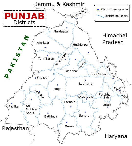
English: State of Punjab (Indian Punjab) with districts marked along with district Headquarters. |
| Сана | |
| Манбаъ | Self made using Inkscape. Source map referred from Punjab govt. site. |
| Муаллиф | Wikigringo |
Иҷозатнома
I, the copyright holder of this work, hereby publish it under the following licenses:

|
Permission is granted to copy, distribute and/or modify this document under the terms of the GNU Free Documentation License, Version 1.2 or any later version published by the Free Software Foundation; with no Invariant Sections, no Front-Cover Texts, and no Back-Cover Texts. A copy of the license is included in the section entitled GNU Free Documentation License. |
This file is licensed under the Creative Commons Attribution-Share Alike 4.0 International, 3.0 Unported, 2.5 Generic, 2.0 Generic and 1.0 Generic license.
- Шумо озодед:
- мубодилот намудан – копӣ, паҳн ва фиристадани асар
- ремикс кардан – татбиқи кор
- Under the following conditions:
- тахсис – You must give appropriate credit, provide a link to the license, and indicate if changes were made. You may do so in any reasonable manner, but not in any way that suggests the licensor endorses you or your use.
- саҳми яксон – If you remix, transform, or build upon the material, you must distribute your contributions under the same or compatible license as the original.
Шумо иҷозатномаи хостаи худро интихоб карда метавонед.
Таърихи файл
Рӯи таърихҳо клик кунед то нусхаи марбути парвандаро бубинед.
| Таърих | Бандангуштӣ | Андоза | Корбар | Тавзеҳ | |
|---|---|---|---|---|---|
| нусхаи феълӣ | 09:25, 10 Январ 2023 | | 2 467 × 2 741 (635 кбайт) | Saad Ali Khan Pakistan | updated district MalerKotla on map |
| 04:45, 7 июли 2020 |  | 2 467 × 2 741 (867 кбайт) | Kaushal Bishnoi | New Update version of Punjab District Map with 22 District. | |
| 14:41, 5 октябри 2013 |  | 1 094 × 848 (127 кбайт) | Ras67 | cropped and optimized | |
| 08:40, 28 апрели 2008 |  | 1 211 × 874 (187 кбайт) | Wikigringo | Uploading a better color version of the file with bigger font size. | |
| 16:01, 26 апрели 2008 |  | 1 269 × 907 (167 кбайт) | Wikigringo | {{Information |Description=State of Punjab, India with districts marked along with district HQ. |Source=Self made using Inkscape. Source map referred from Punjab govt. site. |Date=04/26/2008 |Author=Wikigringo |Permission= |other_versions= }} |
Пайвандҳо
Ин акс дар ҳеҷ саҳифа истифода намешавад.
Истифодаи саросарии парванда
Викиҳои дигари зерин ин файлро истифода мекунанд:
- Истифода дар ar.wikipedia.org
- Истифода дар azb.wikipedia.org
- Истифода дар bh.wikipedia.org
- Истифода дар bn.wikipedia.org
- Истифода дар ca.wikipedia.org
- Истифода дар ceb.wikipedia.org
- Истифода дар en.wikipedia.org
- Истифода дар es.wikipedia.org
- Истифода дар eu.wikipedia.org
- Истифода дар fa.wikipedia.org
- Истифода дар fi.wikipedia.org
- Истифода дар fr.wikipedia.org
- Pendjab (Inde)
- District de Barnala
- District de Faridkot
- District de Fatehgarh Sahib
- District de Fazilka
- District de Firozpur
- District de Gurdaspur
- District de Hoshiarpur
- District de Jalandhar
- District de Kapurthala
- District de Ludhiana
- District de Mansa (Penjab)
- District de Moga
- District de Mohali
- District de Muktsar
View more global usage of this file.