
Акс:South Indian territories.svg

Ҳаҷми пешнамоиши PNG барои файли кунунии SVG: 540 × 599 пиксел. Дигар кайфиятҳо: 216 × 240 пиксел | 432 × 480 пиксел | 692 × 768 пиксел | 922 × 1 024 пиксел | 1 845 × 2 048 пиксел | 672 × 746 пиксел.
Акси аслӣ (SVG парванда, исмӣ 672 × 746 пиксел, андозаи парванда: 306 кбайт)
Хулоса
| Тавсифот | |
| Сана |
7 Январ 2008 (original upload date) |
| Манбаъ |
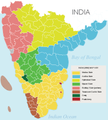
Own work based on: Hyderabad state 1909.jpg, Bombay Prov south 1909.jpg and Plate 34. Sect. XIII- Madras, Mysore and Goa maps from Constable 1893 Hand Atlas.jpg
|
| Муаллиф | AreJay |
| Иҷозат (Пешроҳандозии ин парванда) |
GFDL, CC-Attrib |
| Other versions |
Derivative works of this file: |
Иҷозатнома
AreJay at Англисӣ Википедия, the copyright holder of this work, hereby publishes it under the following licenses:

|
Permission is granted to copy, distribute and/or modify this document under the terms of the GNU Free Documentation License, Version 1.2 or any later version published by the Free Software Foundation; with no Invariant Sections, no Front-Cover Texts, and no Back-Cover Texts. A copy of the license is included in the section entitled GNU Free Documentation License. |
This file is licensed under the Creative Commons Attribution 3.0 Unported license.
Тахсис: AreJay at Англисӣ Википедия
- Шумо озодед:
- мубодилот намудан – копӣ, паҳн ва фиристадани асар
- ремикс кардан – татбиқи кор
- Under the following conditions:
- тахсис – You must give appropriate credit, provide a link to the license, and indicate if changes were made. You may do so in any reasonable manner, but not in any way that suggests the licensor endorses you or your use.
Шумо иҷозатномаи хостаи худро интихоб карда метавонед.
Original upload log
Transferred from en.wikipedia to Commons by Kelly using CommonsHelper.
The original description page was here. All following user names refer to en.wikipedia.
- 2008-04-11 04:19 AreJay 693×748×0 (724956 bytes) '
- 2008-01-09 03:46 AreJay 693×747×0 (599498 bytes) '
- 2008-01-09 03:45 AreJay 693×747×0 (600270 bytes) '
- 2008-01-09 03:43 AreJay 693×747×0 (600126 bytes) '
- 2008-01-09 03:36 AreJay 693×747×0 (600077 bytes) '
- 2008-01-09 03:21 AreJay 693×801×0 (603408 bytes) changes
- 2008-01-08 01:02 AreJay 690×726×0 (615193 bytes) cleanup
- 2008-01-07 18:22 AreJay 690×726×0 (615142 bytes) corrected spelling error
- 2008-01-07 02:35 AreJay 690×726×0 (615141 bytes) {{Information |Description= [[South India]]n states prior to the ''[[States Reorganisation Act]]'' (1956) |Source=self-made |Date= Jan 6, 2008 |Location= Atlanta, GA, USA |Author= [[User:AreJay|]] |Permission= GFDL, CC-Attrib |other_versions={{DerivativeVersions|South Indian territories 2009 de.svg}} }}
Таърихи файл
Рӯи таърихҳо клик кунед то нусхаи марбути парвандаро бубинед.
| Таърих | Бандангуштӣ | Андоза | Корбар | Тавзеҳ | |
|---|---|---|---|---|---|
| нусхаи феълӣ | 23:37, 23 ноябри 2014 | | 672 × 746 (306 кбайт) | Ras67 | black frame and Illustrator data removed |
| 01:35, 13 июни 2008 |  | 693 × 748 (708 кбайт) | File Upload Bot (Magnus Manske) | {{BotMoveToCommons|en.wikipedia}} {{Information |Description={{en|en:South Indian states prior to the ''en:States Reorganisation Act'' (1956)<br/> == Source data and maps == 1. Nizam's Territories: http://mahbubia.com/images/Map%20of%20Hyderab |
Пайвандҳо
Саҳифаҳои зерин ба ин акс пайванданд:
Истифодаи саросарии парванда
Викиҳои дигари зерин ин файлро истифода мекунанд:
- Истифода дар ar.wikipedia.org
- Истифода дар bn.wikipedia.org
- Истифода дар ca.wikipedia.org
- Истифода дар en.wikipedia.org
- Истифода дар es.wikipedia.org
- Истифода дар eu.wikipedia.org
- Истифода дар fa.wikipedia.org
- Истифода дар fr.wikipedia.org
- Истифода дар he.wikipedia.org
- Истифода дар hi.wikipedia.org
- Истифода дар id.wikipedia.org
- Истифода дар kn.wikipedia.org
- Истифода дар ml.wikipedia.org
- Истифода дар mr.wikipedia.org
- Истифода дар ms.wikipedia.org
- Истифода дар ne.wikipedia.org
- Истифода дар ru.wikipedia.org
- Истифода дар ta.wikipedia.org
- Истифода дар te.wikipedia.org
View more global usage of this file.