
Акс:Spree & Kanäle.png

Андозаи ин пешнамоиш: 374 × 599 пиксел. Дигар кайфиятҳо: 150 × 240 пиксел | 299 × 480 пиксел | 479 × 768 пиксел | 639 × 1 024 пиксел | 1 540 × 2 467 пиксел.
Акси аслӣ ((1 540 × 2 467 пиксел, ҳаҷми парванда: 3,98 Мбайт, навъи MIME: image/png))
Хулоса
→ View this map in 50 % projection (770 x 1233 px)
| Тавсифот |
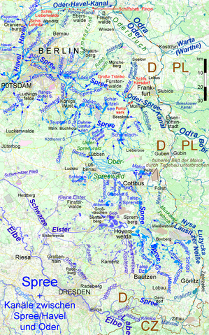
Deutsch: Karte der Spree mit ihren natürlichen und künstlichen Zuflüssen und Verzweigungen, dazu die Kanalverbindungen zwischen dem Flusssystem Spree-Havel und der Oder English: Map of Spree River with its natural and artificial affluents and branches. in addition the canals joining the Spree & Havel river system to Oder River |
| Сана | |
| Манбаъ | Кори худ, using [1] |
| Муаллиф | Ulamm (баҳс) |
Иҷозатнома
I, the copyright holder of this work, hereby publish it under the following licenses:

|
Permission is granted to copy, distribute and/or modify this document under the terms of the GNU Free Documentation License, Version 1.2 or any later version published by the Free Software Foundation; with no Invariant Sections, no Front-Cover Texts, and no Back-Cover Texts. A copy of the license is included in the section entitled GNU Free Documentation License. |
This file is licensed under the Creative Commons Attribution-Share Alike 4.0 International, 3.0 Unported, 2.5 Generic, 2.0 Generic and 1.0 Generic license.
- Шумо озодед:
- мубодилот намудан – копӣ, паҳн ва фиристадани асар
- ремикс кардан – татбиқи кор
- Under the following conditions:
- тахсис – You must give appropriate credit, provide a link to the license, and indicate if changes were made. You may do so in any reasonable manner, but not in any way that suggests the licensor endorses you or your use.
- саҳми яксон – If you remix, transform, or build upon the material, you must distribute your contributions under the same or compatible license as the original.
Шумо иҷозатномаи хостаи худро интихоб карда метавонед.
Таърихи файл
Рӯи таърихҳо клик кунед то нусхаи марбути парвандаро бубинед.
| Таърих | Бандангуштӣ | Андоза | Корбар | Тавзеҳ | |
|---|---|---|---|---|---|
| нусхаи феълӣ | 13:37, 21 май 2016 | | 1 540 × 2 467 (3,98 Мбайт) | Ulamm | upper course of Koselmühlenfließ |
| 11:45, 21 май 2016 |  | 1 540 × 2 467 (3,98 Мбайт) | Ulamm | + Priorgraben u. and. Gewässer, + Weißwasser | |
| 10:13, 24 апрели 2016 |  | 1 540 × 2 467 (3,99 Мбайт) | Ulamm | lock names smaller; some more names of places and flows | |
| 19:31, 18 апрели 2016 |  | 1 540 × 2 467 (3,99 Мбайт) | Ulamm | two locks corrected | |
| 22:19, 7 апрели 2016 |  | 1 540 × 2 467 (3,99 Мбайт) | Ulamm | some more courses of water, two more placenames | |
| 21:54, 4 апрели 2016 |  | 1 540 × 2 467 (4 Мбайт) | Ulamm | Stöbber with "ö" and some minor drawings | |
| 10:00, 1 апрели 2016 |  | 1 540 × 2 467 (4 Мбайт) | Ulamm | wrong "correction" reverted: GAMengrund was o.k. | |
| 09:18, 1 апрели 2016 |  | 1 540 × 2 467 (4 Мбайт) | Ulamm | GaRmengrund | |
| 23:42, 29 марти 2016 |  | 1 540 × 2 467 (4 Мбайт) | Ulamm | Oder-HAVEL-Kanal ;-) | |
| 01:44, 29 марти 2016 |  | 1 540 × 2 467 (3,99 Мбайт) | Ulamm | + Ludwigsfelde and one group of river courses a bit lighter |
Пайвандҳо
Саҳифаҳои зерин ба ин акс пайванданд:
Истифодаи саросарии парванда
Викиҳои дигари зерин ин файлро истифода мекунанд:
- Истифода дар azb.wikipedia.org
- Истифода дар de.wikipedia.org
- Истифода дар dsb.wikipedia.org
- Истифода дар fi.wikipedia.org
- Истифода дар hsb.wikipedia.org
- Истифода дар nl.wikipedia.org
- Истифода дар no.wikipedia.org
- Истифода дар ro.wikipedia.org
- Истифода дар ru.wikipedia.org