
Акс:Tajikistan Map TI-map.gif
Нусхаи ҳаҷман ва сифатан баландтар дастрас нест.
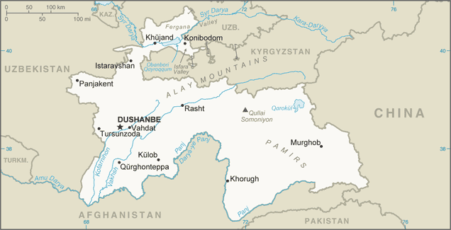
Tajikistan_Map_TI-map.gif ((636 × 325 пиксел, ҳаҷми парванда: 29 кбайт, навъи MIME: image/gif))
Хулоса
| Тавсифот |
English: Tajikistan Map (This version of the map includes significant changes from the previous version of the map including changes to the China-Tajikistan border.) |
| Сана | 2010s |
| Манбаъ | [1] |
| Муаллиф | CIA Factbook |
| Other versions |
|

![[1]](https://www.cia.gov/library/publications/the-world-factbook/attachments/maps/TI-map.gif)
Иҷозатнома
This work is in the public domain in the United States because it is a work prepared by an officer or employee of the United States Government as part of that person’s official duties under the terms of Title 17, Chapter 1, Section 105 of the US Code.
Note: This only applies to original works of the Federal Government and not to the work of any individual U.S. state, territory, commonwealth, county, municipality, or any other subdivision. This template also does not apply to postage stamp designs published by the United States Postal Service since 1978. (See § 313.6(C)(1) of Compendium of U.S. Copyright Office Practices). It also does not apply to certain US coins; see The US Mint Terms of Use.
|
 | |
| This file has been identified as being free of known restrictions under copyright law, including all related and neighboring rights. | ||
Таърихи файл
Рӯи таърихҳо клик кунед то нусхаи марбути парвандаро бубинед.
| Таърих | Бандангуштӣ | Андоза | Корбар | Тавзеҳ | |
|---|---|---|---|---|---|
| нусхаи феълӣ | 00:49, 21 Январ 2020 | | 636 × 325 (29 кбайт) | Geographyinitiative | User created page with UploadWizard |
Пайвандҳо
Саҳифаҳои зерин ба ин акс пайванданд:
Истифодаи саросарии парванда
Викиҳои дигари зерин ин файлро истифода мекунанд:
- Истифода дар ar.wikipedia.org
- Истифода дар ast.wikipedia.org
- Истифода дар bg.wiktionary.org
- Истифода дар bn.wikipedia.org
- Истифода дар ca.wikipedia.org
- Истифода дар cs.wikipedia.org
- Истифода дар dsb.wikipedia.org
- Истифода дар el.wikipedia.org
- Истифода дар en.wikipedia.org
- Истифода дар en.wiktionary.org
- Истифода дар eo.wikinews.org
- Истифода дар es.wikipedia.org
- Истифода дар eu.wikipedia.org
- Истифода дар fa.wikipedia.org
- Истифода дар fr.wikipedia.org
- Истифода дар gd.wikipedia.org
- Истифода дар gl.wikipedia.org
- Истифода дар ha.wikipedia.org
- Истифода дар hif.wikipedia.org
- Истифода дар hr.wikipedia.org
- Истифода дар id.wikipedia.org
- Истифода дар is.wikipedia.org
- Истифода дар it.wikipedia.org
View more global usage of this file.