
Акс:The Citadel of Alanya.jpg
Акси аслӣ ((1 000 × 750 пиксел, ҳаҷми парванда: 360 кбайт, навъи MIME: image/jpeg))
Хулоса
| Тавсифот |
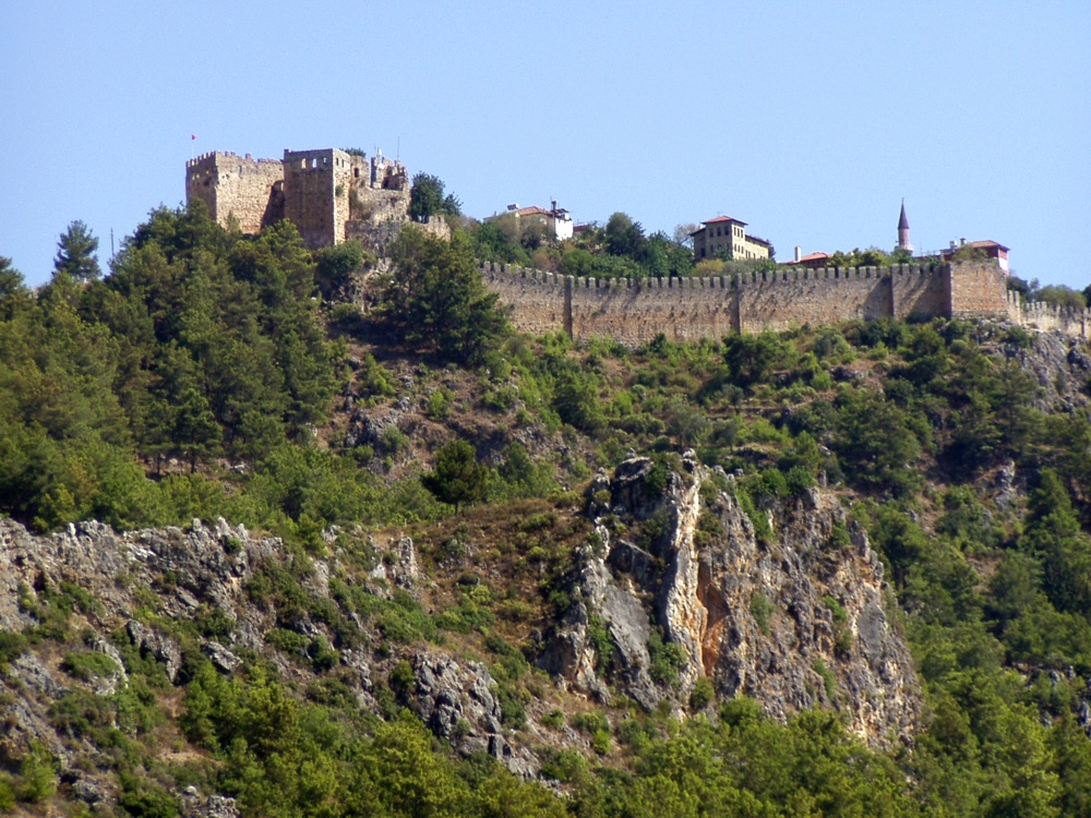
The citadel viewed from the city. The Citadel of Alanya, the walls of which are nearly 6.5 kilometres long, is on a peninsula whose height is up to 250 metres from the sea level. Although the settlement on Alanya peninsula, also known as Kandeleri, dates back to the Hellenistic Era, its cultural characteristics that can be seen today are thanks to Selcuks of the 13th century. The citadel was constructed on the demand of the Sultan of Selcuks, Alaaddin Keykubat, who conquered and had the city rebuilt in 1221. The citadel has 83 towers and 140 bastions. Nearly 400 cisterns were built to supply the city surrounded by walks in the medieval times with water. Some of the cisterns are still used today. The Seljuk Empire used Alanya as a second capital city in addition to Konya and used the city as a winter residence and made improvements there. Mongol attacks in 1243 and the Invasion of Anatolia by Egyptian Memluks weakened the Seljuk Empire which was divided in 1300, and the region came under the reign of the Karamano?ullar? dynasty. In 1427 Alanya was sold to the Memluk Sultan for five thousand gold pieces, and then in 1471 the city was included within the borders of the Ottoman Empire by Mehmet II The Conqueror. ( www.alanya.com.tr/en/47-Historical-Places.html ) |
| Сана | |
| Манбаъ |
Türkiye - The Citadel of Alanya
|
| Муаллиф | Robin & Bazylek from Kraków, Poland |
| Camera location | | View this and other nearby images on: OpenStreetMap |
|---|
Иҷозатнома
- Шумо озодед:
- мубодилот намудан – копӣ, паҳн ва фиристадани асар
- ремикс кардан – татбиқи кор
- Under the following conditions:
- тахсис – You must give appropriate credit, provide a link to the license, and indicate if changes were made. You may do so in any reasonable manner, but not in any way that suggests the licensor endorses you or your use.
| This image, originally posted to Flickr, was reviewed on April 21, 2009 by the administrator or reviewer File Upload Bot (Magnus Manske), who confirmed that it was available on Flickr under the stated license on that date. |
Таърихи файл
Рӯи таърихҳо клик кунед то нусхаи марбути парвандаро бубинед.
| Таърих | Бандангуштӣ | Андоза | Корбар | Тавзеҳ | |
|---|---|---|---|---|---|
| нусхаи феълӣ | 15:59, 21 апрели 2009 | | 1 000 × 750 (360 кбайт) | File Upload Bot (Magnus Manske) | {{Information |Description= The citadel viewed from the city. The Citadel of Alanya, the walls of which are nearly 6.5 kilometres long, is on a peninsula whose height is up to 250 metres from the sea level. Although the settlement on Alanya peninsula, a |
Пайвандҳо
Саҳифаҳои зерин ба ин акс пайванданд:
Истифодаи саросарии парванда
Викиҳои дигари зерин ин файлро истифода мекунанд:
- Истифода дар ar.wikipedia.org
- Истифода дар ba.wikipedia.org
- Истифода дар de.wikipedia.org
- Истифода дар es.wikipedia.org
- Истифода дар fr.wikipedia.org
- Истифода дар hu.wikipedia.org
- Истифода дар hy.wikipedia.org
- Истифода дар pt.wikipedia.org
- Истифода дар ru.wikipedia.org