
Акс:The friendship bridge connects Mangusar, Uzbekistan and Hariatan, Afghanistan.jpg

Андозаи ин пешнамоиш: 800 × 532 пиксел. Дигар кайфиятҳо: 320 × 213 пиксел | 640 × 426 пиксел | 1 024 × 681 пиксел | 1 280 × 852 пиксел | 2 560 × 1 703 пиксел | 4 256 × 2 832 пиксел.
Акси аслӣ ((4 256 × 2 832 пиксел, ҳаҷми парванда: 4,22 Мбайт, навъи MIME: image/jpeg))
Хулоса
| Тавсифот |
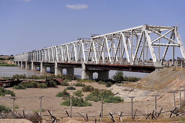
The "Friendship Bridge" runs across the Amu Darya River between Uzbekistan and Afghanistan. The friendship bridge connects Mangusar, Uzbekistan and Hariatan, Afghanistan. (U.S. Air Force Photo By Staff Sgt. Bradley Lail) (released) |
|||
| Сана | ||||
| Манбаъ |
|
|||
| Муаллиф | Bradley Lail via ISAF Headquarters Public Affairs Office from Kabul, Afghanistan |

| Camera location | | View this and other nearby images on: OpenStreetMap |
|---|
Иҷозатнома
This file is licensed under the Creative Commons Attribution 2.0 Generic license.
- Шумо озодед:
- мубодилот намудан – копӣ, паҳн ва фиристадани асар
- ремикс кардан – татбиқи кор
- Under the following conditions:
- тахсис – You must give appropriate credit, provide a link to the license, and indicate if changes were made. You may do so in any reasonable manner, but not in any way that suggests the licensor endorses you or your use.
| This image was originally posted to Flickr by isafmedia at https://www.flickr.com/photos/29456680@N06/4820329829. It was reviewed on 21 август 2010 by FlickreviewR and was confirmed to be licensed under the terms of the cc-by-2.0. |
Таърихи файл
Рӯи таърихҳо клик кунед то нусхаи марбути парвандаро бубинед.
| Таърих | Бандангуштӣ | Андоза | Корбар | Тавзеҳ | |
|---|---|---|---|---|---|
| нусхаи феълӣ | 12:15, 21 августи 2010 | | 4 256 × 2 832 (4,22 Мбайт) | FlickreviewR | Replacing image by its original image from Flickr |
| 11:18, 21 августи 2010 |  | 240 × 160 (36 кбайт) | Geo Swan | {{Information |Description=The "Friendship Bridge" runs across the Amu Darya River between Uzbekistan and Afghanistan. The friendship bridge connects Mangusar, Uzbekistan and Hariatan, Afghanistan. (U.S. Air Force Photo By Staff Sgt. Bradley Lail) (rele |
Пайвандҳо
Саҳифаҳои зерин ба ин акс пайванданд:
Истифодаи саросарии парванда
Викиҳои дигари зерин ин файлро истифода мекунанд:
- Истифода дар ba.wikipedia.org
- Истифода дар bn.wikipedia.org
- Истифода дар de.wikipedia.org
- Истифода дар en.wikipedia.org
- Истифода дар en.wikivoyage.org
- Истифода дар es.wikivoyage.org
- Истифода дар fa.wikipedia.org
- Истифода дар fr.wikipedia.org
- Истифода дар he.wikipedia.org
- Истифода дар hi.wikipedia.org
- Истифода дар it.wikipedia.org
- Истифода дар ja.wikipedia.org
- Истифода дар kk.wikipedia.org
- Истифода дар lt.wikipedia.org
- Истифода дар lv.wikipedia.org
- Истифода дар pl.wikipedia.org
- Истифода дар ru.wikipedia.org
- Истифода дар sv.wikipedia.org
- Истифода дар tr.wikipedia.org
- Истифода дар uk.wikipedia.org
- Истифода дар uz.wikipedia.org
- Истифода дар zh.wikipedia.org