
Акс:Transoxiana 8th century.svg

Ҳаҷми пешнамоиши PNG барои файли кунунии SVG: 800 × 388 пиксел. Дигар кайфиятҳо: 320 × 155 пиксел | 640 × 310 пиксел | 1 024 × 496 пиксел | 1 280 × 620 пиксел | 2 560 × 1 241 пиксел | 1 300 × 630 пиксел.
Акси аслӣ (SVG парванда, исмӣ 1 300 × 630 пиксел, андозаи парванда: 1,86 Мбайт)
Хулоса
| Тавсифот |
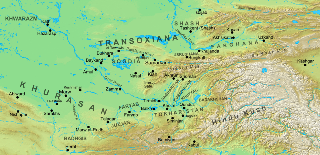
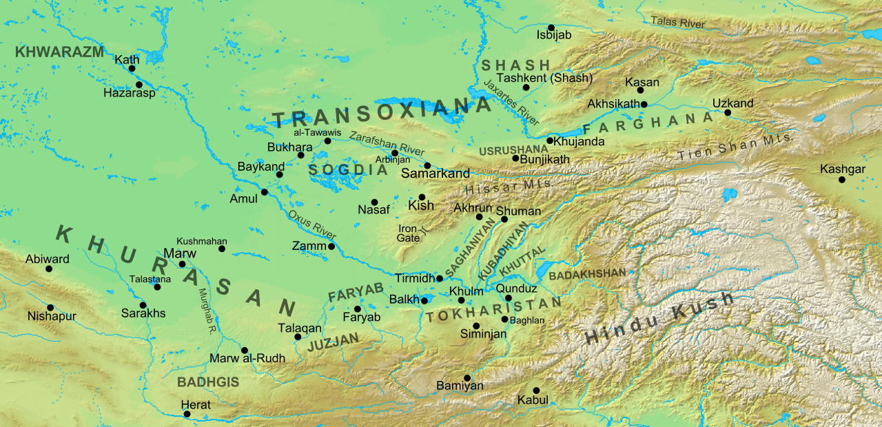
English: Map of the region and principal localities of Transoxiana in the 8th century —.
|
| Сана | |
| Манбаъ | Кори худ |
| Муаллиф | Cplakidas |
| Other versions |
[]
|


Иҷозатнома
I, the copyright holder of this work, hereby publish it under the following license:
This file is licensed under the Creative Commons Attribution-Share Alike 3.0 Unported license.
- Шумо озодед:
- мубодилот намудан – копӣ, паҳн ва фиристадани асар
- ремикс кардан – татбиқи кор
- Under the following conditions:
- тахсис – You must give appropriate credit, provide a link to the license, and indicate if changes were made. You may do so in any reasonable manner, but not in any way that suggests the licensor endorses you or your use.
- саҳми яксон – If you remix, transform, or build upon the material, you must distribute your contributions under the same or compatible license as the original.
Таърихи файл
Рӯи таърихҳо клик кунед то нусхаи марбути парвандаро бубинед.
| Таърих | Бандангуштӣ | Андоза | Корбар | Тавзеҳ | |
|---|---|---|---|---|---|
| нусхаи феълӣ | 15:30, 2 октябри 2016 | | 1 300 × 630 (1,86 Мбайт) | Cplakidas | added Qunduz |
| 10:32, 15 октябри 2012 |  | 1 300 × 630 (1,86 Мбайт) | Cplakidas | larger map to include most of Khurasan, additions of cities & provinces | |
| 13:29, 24 Январ 2012 |  | 800 × 500 (1 Мбайт) | Cplakidas | major revision with more additions & corrections | |
| 17:28, 8 Декабри 2011 |  | 800 × 500 (955 кбайт) | Cplakidas | added more details, some corrections | |
| 20:34, 25 июли 2011 |  | 800 × 500 (895 кбайт) | Cplakidas |
Пайвандҳо
Саҳифаҳои зерин ба ин акс пайванданд:
Истифодаи саросарии парванда
Викиҳои дигари зерин ин файлро истифода мекунанд:
- Истифода дар arz.wikipedia.org
- Истифода дар azb.wikipedia.org
- Истифода дар az.wikipedia.org
- Türkdilli dövlətlər
- Usruşana
- Börküyarıq
- Talas döyüşü
- Bahilə qalası uğrunda döyüş
- Susuzluq günü
- Ağsu döyüşü (717)
- Bəykənd döyüşü
- Vikipediya:Həftənin yaxşı məqaləsi/noyabr 2020
- Vikipediya:Həftənin yaxşı məqaləsi/dekabr 2020
- Vikipediya:Həftənin yaxşı məqaləsi/48. Həftə 2020
- Vikipediya:Həftənin yaxşı məqaləsi/49. Həftə 2020
- Böyük Xorasan
- Истифода дар bg.wikipedia.org
- Истифода дар bn.wikipedia.org
- Истифода дар bs.wikipedia.org
- Истифода дар ca.wikipedia.org
- Истифода дар cs.wikipedia.org
- Истифода дар de.wikipedia.org
- Истифода дар de.wikiversity.org
- Истифода дар el.wikipedia.org
- Истифода дар en.wikipedia.org
View more global usage of this file.