
Акс:Tripura map.png
Андозаи ин пешнамоиш: 413 × 599 пиксел. Дигар кайфиятҳо: 165 × 240 пиксел | 331 × 480 пиксел | 899 × 1 304 пиксел.
Акси аслӣ ((899 × 1 304 пиксел, ҳаҷми парванда: 164 кбайт, навъи MIME: image/png))

|
This locator map image could be re-created using vector graphics as an SVG file. This has several advantages; see Commons:Media for cleanup for more information. If an SVG form of this image is available, please upload it and afterwards replace this template with
{{vector version available|new image name}}.
It is recommended to name the SVG file “Tripura map.svg”—then the template Vector version available (or Vva) does not need the new image name parameter. |
Хулоса
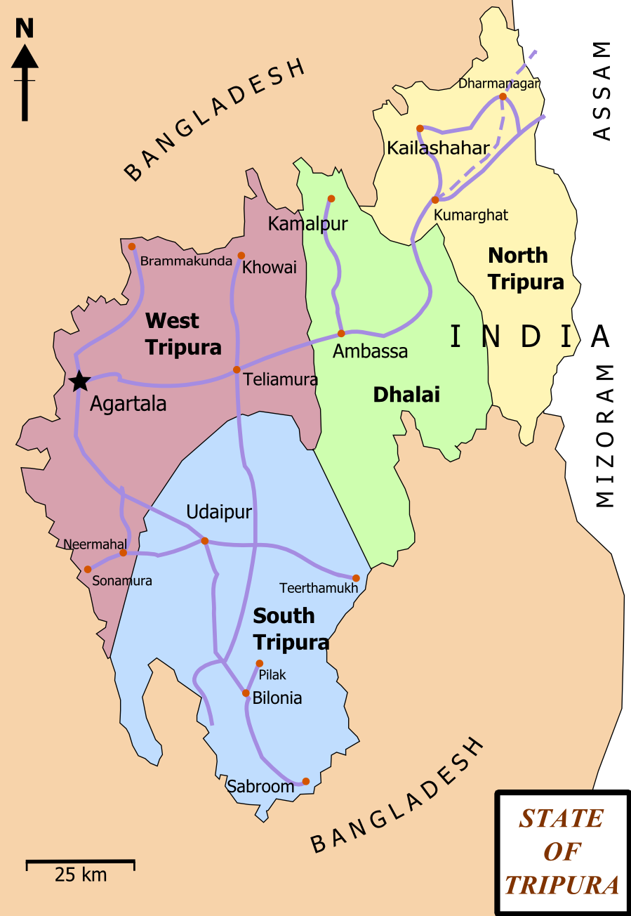
| Тавсифот | Map of State of Tripura. The map shows the former 4 districts of Tripura, with the state's roads and railway networks detailed. Railway was extended upto Agartala from Kumbarghat and opened by 2008.[1] |
| Сана | |
| Манбаъ | Кори худ |
| Муаллиф | Wikigringo |
| Иҷозат (Пешроҳандозии ин парванда) |
attribution to author. |
| Other versions | Tripura locator map blank.svg.png |
| Унвони мақола |
Tripura locator map |
| Description |
Locator map of the state of Tripura, India with district boundaries. |
| Сана | |
| Манбаъ |
Кори худ |
| Падидоваранда | |
| Иҷозат (Пешроҳандозии ин парванда) |
I, the copyright holder of this work, hereby publish it under the following license: This file is licensed under the Creative Commons Attribution-Share Alike 3.0 Unported license.
|
| Geotemporal data | |
| Date depicted | second half of 20 century ва 21 century |
| Georeferencing | If inappropriate please set warp_status = skip to hide. |
| Archival data | |
| Эзоҳот | Part of WikiProject India Maps |
Иҷозатнома
I, the copyright holder of this work, hereby publish it under the following licenses:

|
Permission is granted to copy, distribute and/or modify this document under the terms of the GNU Free Documentation License, Version 1.2 or any later version published by the Free Software Foundation; with no Invariant Sections, no Front-Cover Texts, and no Back-Cover Texts. A copy of the license is included in the section entitled GNU Free Documentation License. |
This file is licensed under the Creative Commons Attribution-Share Alike 4.0 International, 3.0 Unported, 2.5 Generic, 2.0 Generic and 1.0 Generic license.
- Шумо озодед:
- мубодилот намудан – копӣ, паҳн ва фиристадани асар
- ремикс кардан – татбиқи кор
- Under the following conditions:
- тахсис – You must give appropriate credit, provide a link to the license, and indicate if changes were made. You may do so in any reasonable manner, but not in any way that suggests the licensor endorses you or your use.
- саҳми яксон – If you remix, transform, or build upon the material, you must distribute your contributions under the same or compatible license as the original.
Шумо иҷозатномаи хостаи худро интихоб карда метавонед.
Таърихи файл
Рӯи таърихҳо клик кунед то нусхаи марбути парвандаро бубинед.
| Таърих | Бандангуштӣ | Андоза | Корбар | Тавзеҳ | |
|---|---|---|---|---|---|
| нусхаи феълӣ | 17:06, 15 феврали 2012 | | 899 × 1 304 (164 кбайт) | Ras67 | cropped and optimized |
| 13:15, 27 феврали 2008 |  | 921 × 1 326 (229 кбайт) | Wikigringo | {{Information |Description=Map of State of Tripura. Map shows the 4 districts of Tripura along with roadways and small railway network present in the state. |Source=self-made |Date=02/27/2008 |Author= Wikigringo |Permission=attribution |
Пайвандҳо
Ин акс дар ҳеҷ саҳифа истифода намешавад.
Истифодаи саросарии парванда
Викиҳои дигари зерин ин файлро истифода мекунанд:
- Истифода дар as.wikipedia.org
- Истифода дар bn.wikipedia.org
- ধর্মনগর
- কমলপুর
- ত্রিপুরা বিধানসভা নির্বাচন, ২০১৩
- ত্রিপুরা বিধানসভা নির্বাচন, ২০০৮
- ত্রিপুরা বিধানসভা নির্বাচন, ২০০৩
- ত্রিপুরা বিধানসভা নির্বাচন, ১৯৭২
- ত্রিপুরা বিধানসভা নির্বাচন, ১৯৭৭
- ত্রিপুরা বিধানসভা নির্বাচন, ১৯৮৩
- ত্রিপুরা বিধানসভা নির্বাচন, ১৯৮৮
- ত্রিপুরা বিধানসভা নির্বাচন, ১৯৯৩
- ত্রিপুরা বিধানসভা নির্বাচন, ১৯৯৮
- Истифода дар ca.wikipedia.org
- Истифода дар en.wikipedia.org
- Portal:India/Selected picture candidates
- Belonia, India
- User:Gppande/Album
- Portal:India/Selected picture candidates/Tripura district map
- 2008 Tripura Legislative Assembly election
- 2013 Tripura Legislative Assembly election
- Wikipedia:Graphics Lab/Map workshop/Archive/Apr 2013
- Santirbazar
- 2003 Tripura Legislative Assembly election
- 1998 Tripura Legislative Assembly election
- 1993 Tripura Legislative Assembly election
- 1988 Tripura Legislative Assembly election
- 1983 Tripura Legislative Assembly election
- 1977 Tripura Legislative Assembly election
- 1972 Tripura Legislative Assembly election
- Истифода дар eu.wikipedia.org
- Истифода дар fa.wikipedia.org
- Истифода дар gom.wikipedia.org
- Истифода дар hi.wikipedia.org
- Истифода дар hr.wikipedia.org
- Истифода дар incubator.wikimedia.org
- Истифода дар kk.wikipedia.org
- Истифода дар ml.wikipedia.org
- Истифода дар ne.wikipedia.org
- Истифода дар new.wikipedia.org
View more global usage of this file.