
Акс:Buyids within the Middle East, ca. 970.png
Андозаи ин пешнамоиш: 800 × 453 пиксел. Дигар кайфиятҳо: 320 × 181 пиксел | 640 × 362 пиксел | 1 202 × 680 пиксел.
Акси аслӣ ((1 202 × 680 пиксел, ҳаҷми парванда: 359 кбайт, навъи MIME: image/png))
Хулоса
| Тавсифот |
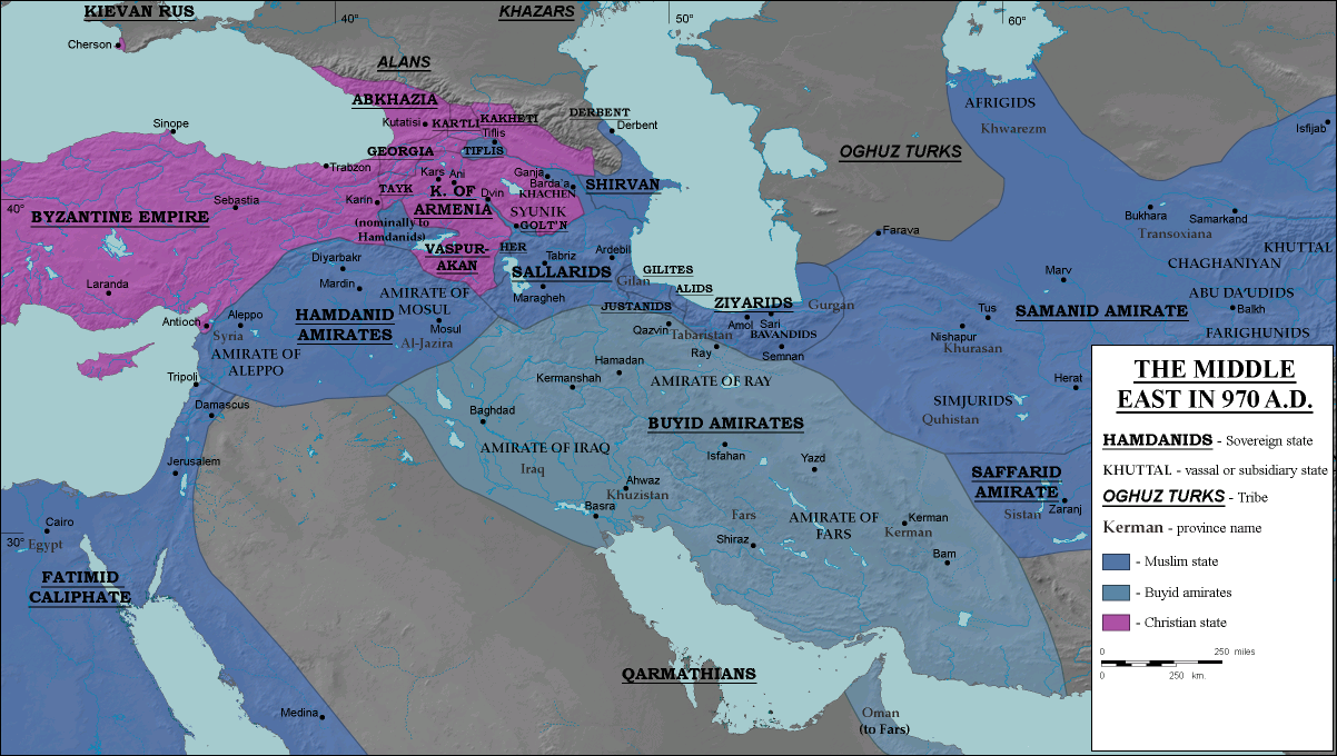
English: The domains of the Buyid dynasty highlighted among other Muslim (blue) and eastern Christian (purple) states, ca. 970 CE |
| Сана | |
| Манбаъ |
Transferred from en.wikipedia to Commons.
|
| Муаллиф | ro4444 |
| Иҷозат (Пешроҳандозии ин парванда) |
. Original uploader was Ro4444 at en.wikipedia CC-BY-SA-3.0; Released under the GNU Free Documentation License. |
| Other versions |
|

Иҷозатнома
Ro4444 at Англисӣ Википедия, the copyright holder of this work, hereby publishes it under the following licenses:
This file is licensed under the Creative Commons Attribution-Share Alike 3.0 Unported license.
Тахсис: Ro4444 at Англисӣ Википедия
- Шумо озодед:
- мубодилот намудан – копӣ, паҳн ва фиристадани асар
- ремикс кардан – татбиқи кор
- Under the following conditions:
- тахсис – You must give appropriate credit, provide a link to the license, and indicate if changes were made. You may do so in any reasonable manner, but not in any way that suggests the licensor endorses you or your use.
- саҳми яксон – If you remix, transform, or build upon the material, you must distribute your contributions under the same or compatible license as the original.

|
Permission is granted to copy, distribute and/or modify this document under the terms of the GNU Free Documentation License, Version 1.2 or any later version published by the Free Software Foundation; with no Invariant Sections, no Front-Cover Texts, and no Back-Cover Texts. A copy of the license is included in the section entitled GNU Free Documentation License. |
Шумо иҷозатномаи хостаи худро интихоб карда метавонед.
Original upload log
The original description page was here. All following user names refer to en.wikipedia.
- 2008-07-05 16:20 Ro4444 1202×680× (368060 bytes) == Description == {{Information |Description= {{en| Political map in English of the Middle East in 970 A.D.}} |Source=Own work. {{clr}} Data sources : * Background map : [[http://en.wikipedia.org/wiki/Topographic_map#Global_1-kilometer_map]] (SRTM3 v.2) (
- 2008-06-29 04:51 Ro4444 1202×680× (368939 bytes) == Summary == == Description == {{Information |Description= {{en| Political map in English of the Middle East in 970 A.D.}} |Source=Own work. {{clr}} Data sources : * Background map : [[http://en.wikipedia.org/wiki/Topographic_map#Global_1-kilometer_map]]
- 2008-06-27 21:24 Ro4444 1202×680× (369445 bytes) == Summary == == Description == {{Information |Description= {{en| Political map in English of the Middle East in 970 A.D.}} |Source=Own work. {{clr}} Data sources : * Background map : [[http://en.wikipedia.org/wiki/Topographic_map#Global_1-kilometer_map]]
- 2008-06-27 17:30 Ro4444 1202×680× (369418 bytes) == Description == {{Information |Description= {{en| Political map in English of the Middle East in 970 A.D.}} |Source=Own work. {{clr}} Data sources : * Background map : [[http://en.wikipedia.org/wiki/Topographic_map#Global_1-kilometer_map]] (SRTM3 v.2) (
Таърихи файл
Рӯи таърихҳо клик кунед то нусхаи марбути парвандаро бубинед.
| Таърих | Бандангуштӣ | Андоза | Корбар | Тавзеҳ | |
|---|---|---|---|---|---|
| нусхаи феълӣ | 14:55, 26 июли 2012 | | 1 202 × 680 (359 кбайт) | OgreBot | (BOT): Reverting to most recent version before archival |
| 14:55, 26 июли 2012 |  | 1 202 × 680 (360 кбайт) | OgreBot | (BOT): Uploading old version of file from en.wikipedia; originally uploaded on 2008-06-29 04:51:30 by Ro4444 | |
| 14:55, 26 июли 2012 |  | 1 202 × 680 (361 кбайт) | OgreBot | (BOT): Uploading old version of file from en.wikipedia; originally uploaded on 2008-06-27 21:24:54 by Ro4444 | |
| 14:55, 26 июли 2012 |  | 1 202 × 680 (361 кбайт) | OgreBot | (BOT): Uploading old version of file from en.wikipedia; originally uploaded on 2008-06-27 17:30:29 by Ro4444 | |
| 15:34, 25 июли 2012 |  | 1 202 × 680 (359 кбайт) | Cplakidas | {{Information |Description={{en|The domains of the en:Buyid dynasty highlighted among other Muslim (blue) and eastern Christian (purple) states, ca. 970 CE}} |Source=Transferred from [http://en.wikipedia.org en.wikipedia]<br/> (Original text : ''... |
Пайвандҳо
Саҳифаҳои зерин ба ин акс пайванданд:
Истифодаи саросарии парванда
Викиҳои дигари зерин ин файлро истифода мекунанд:
- Истифода дар ar.wikipedia.org
- Истифода дар av.wikipedia.org
- Истифода дар bg.wikipedia.org
- Истифода дар ca.wikipedia.org
- Истифода дар de.wikipedia.org
- Истифода дар de.wikiversity.org
- Истифода дар el.wikipedia.org
- Истифода дар en.wikipedia.org
- Истифода дар en.wikibooks.org
- Истифода дар es.wikipedia.org
- Истифода дар fa.wikipedia.org
- Истифода дар fi.wikipedia.org
- Истифода дар he.wikipedia.org
- Истифода дар it.wikipedia.org
- Истифода дар ja.wikipedia.org
- Истифода дар ku.wikipedia.org
- Истифода дар nl.wikipedia.org
- Истифода дар pnb.wikipedia.org
- Истифода дар pt.wikipedia.org
- Истифода дар ru.wikipedia.org
- Истифода дар uz.wikipedia.org
- Истифода дар zh.wikipedia.org