
Акс:77 - Carthagène - Décembre 2008.JPG

Акси аслӣ ((3 168 × 4 752 пиксел, ҳаҷми парванда: 2,28 Мбайт, навъи MIME: image/jpeg))
Хулоса
| Тавсифот |
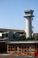
Français : Aéroport International Rafael Núñez à Carthagène des Indes, Colombie
English: Cartagena’s Rafael Núñez International Airport, Colombia |
||
| Сана | |||
| Манбаъ | Кори худ | ||
| Муаллиф | Martin St-Amant (S23678) | ||
| Иҷозат (Пешроҳандозии ин парванда) |
|

| Camera location | | View this and other nearby images on: OpenStreetMap |
|---|
Иҷозатнома
- Шумо озодед:
- мубодилот намудан – копӣ, паҳн ва фиристадани асар
- ремикс кардан – татбиқи кор
- Under the following conditions:
- тахсис – You must give appropriate credit, provide a link to the license, and indicate if changes were made. You may do so in any reasonable manner, but not in any way that suggests the licensor endorses you or your use.
- саҳми яксон – If you remix, transform, or build upon the material, you must distribute your contributions under the same or compatible license as the original.
Таърихи файл
Рӯи таърихҳо клик кунед то нусхаи марбути парвандаро бубинед.
| Таърих | Бандангуштӣ | Андоза | Корбар | Тавзеҳ | |
|---|---|---|---|---|---|
| нусхаи феълӣ | 20:09, 31 марти 2009 | | 3 168 × 4 752 (2,28 Мбайт) | S23678 | {{Information |Description={{User:S23678/Traduction}} {{fr|1=Aéroport International Rafael Núñez à Carthagène des Indes, Colombie}} {{en|1=Cartagena’s Rafael Núñez International Airport, Colombia}} |Source=travail personnel (own work) |Author=Mar |
Пайвандҳо
Саҳифаҳои зерин ба ин акс пайванданд:
Истифодаи саросарии парванда
Викиҳои дигари зерин ин файлро истифода мекунанд:
- Истифода дар ast.wikipedia.org
- Истифода дар avk.wikipedia.org
- Истифода дар ceb.wikipedia.org
- Истифода дар de.wikivoyage.org
- Истифода дар en.wikipedia.org
- Истифода дар en.wikivoyage.org
- Истифода дар es.wikipedia.org
- Истифода дар es.wikivoyage.org
- Истифода дар fa.wikipedia.org
- Истифода дар fr.wikipedia.org
- Истифода дар fr.wikivoyage.org
- Истифода дар gl.wikipedia.org
- Истифода дар he.wikipedia.org
- Истифода дар hu.wikipedia.org
- Истифода дар id.wikipedia.org
- Истифода дар it.wikipedia.org
- Истифода дар pl.wikipedia.org
- Истифода дар pt.wikipedia.org
- Истифода дар www.wikidata.org