
Акс:AFW - FAA airport diagram.png

Андозаи ин пешнамоиш: 390 × 599 пиксел. Дигар кайфиятҳо: 156 × 240 пиксел | 516 × 792 пиксел.
Акси аслӣ ((516 × 792 пиксел, ҳаҷми парванда: 61 кбайт, навъи MIME: image/png))
Хулоса
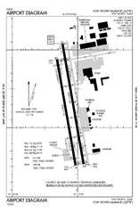
| Тавсифот | FAA airport diagram for Fort Worth Alliance Airport (AFW) in Fort Worth, Texas, United States. |
| Сана | Effective 2006-09-28 to 2006-10-26. |
| Манбаъ |
http://naco.faa.gov/d-tpp/0610/06918AD.PDF Note: this URL changes every 28 days; the airport article should contain a link to the current FAA diagram. |
| Муаллиф | Produced by the National Aeronautical Charting Office (NACO), a department of the Federal Aviation Administration (FAA). |
| Иҷозат (Пешроҳандозии ин парванда) |
Public domain. |
Иҷозатнома
This image or file is a work of a Federal Aviation Administration employee, taken or made as part of that person's official duties. As a work of the U.S. federal government, the image is in the public domain in the United States.
|
 |
Original upload log
(All user names refer to en:wikipedia)
- 2006-10-28 01:22 MJHankel 516×792×8 (62222 bytes) Airport map Fort Worth Alliance Airport {{PD-USGov-FAA}}
Original upload log
| date/time | username | resolution | size | edit summary |
|---|---|---|---|---|
| 16:46, 15 November 2007 | User:File Upload Bot (Magnus Manske) | 516×792 | 61 KB | {{BotMoveToCommons|en.wikipedia}} {{Information |Description={{en|Airport map Fort Worth Alliance Airport <a href="http://en.wikipedia.org/wiki/commons:category:Fort_Worth_Alliance_Airport" class="extiw" title="en:commons:category:Fort_Worth_Alliance_Airport">en:commons:category:Fort Worth Alliance Airport</a> <a href="http://en.wikipedia.org/wiki/commons:category:Federal_Aviation_Administration" class="extiw" title="en:commons:category:Federal_Aviation_Administration">en:commons:category:Federal Aviation Administration</a> <a href="http://en.wikipedia.org/wiki/commons:category:Maps" class="extiw" title="en:commons:category:Maps">en:commons:category:Maps</a>}} |Sou |
Таърихи файл
Рӯи таърихҳо клик кунед то нусхаи марбути парвандаро бубинед.
| Таърих | Бандангуштӣ | Андоза | Корбар | Тавзеҳ | |
|---|---|---|---|---|---|
| нусхаи феълӣ | 12:23, 13 июни 2008 | | 516 × 792 (61 кбайт) | BetacommandBot | move approved by: User:Superm401 This image was moved from Image:AFW airport map.PNG == Summary == {{Information | Description = FAA airport diagram for Fort Worth Alliance Airport (AFW) in Fort Worth, Texas, |
Пайвандҳо
Саҳифаҳои зерин ба ин акс пайванданд:
Истифодаи саросарии парванда
Викиҳои дигари зерин ин файлро истифода мекунанд:
- Истифода дар arz.wikipedia.org
- Истифода дар ceb.wikipedia.org
- Истифода дар fa.wikipedia.org
- Истифода дар ur.wikipedia.org
- Истифода дар www.wikidata.org