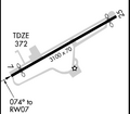
Акс:Airport diagram Blairstown NJ 1N7.png

Page contents not supported in other languages.
Мавод аз Википедиа — донишномаи озод

Акси аслӣ((355 × 620 пиксел, ҳаҷми парванда: 15 кбайт, навъи MIME: image/png))

Ин файл аз Викианбор ва дар дигар лоиҳаҳо метавонад истифода шавад. Тафсилоти ин файл саҳифаи тафсилоти файл дар зер нишон дода шудааст.

This file may be updated to reflect new information.
If you wish to use a specific version of the file without new updates being mirrored, please upload the required version as a separate file.

Хулоса

Тавсифот Runway diagram for Blairstown Airport (1N7) in Blairstown, New Jersey, United States.
Сана Variable, as the new version may be uploaded regularly (see particular version's description).
Манбаъ Cropped from FAA terminal procedure; the airport article contains a link to the current FAA terminal procedures.
Муаллиф Produced by the National Aeronautical Charting Office (NACO), a department of the Federal Aviation Administration (FAA).
Иҷозат
(Пешроҳандозии ин парванда)
Public domain.

Иҷозатнома

Public domain
This image or file is a work of a Federal Aviation Administration employee, taken or made as part of that person's official duties. As a work of the U.S. federal government, the image is in the public domain in the United States.

English | italiano | македонски | മലയാളം | Nederlands | русский | sicilianu | українська | 中文 | +/−

Captions

Add a one-line explanation of what this file represents

Items portrayed in this file

тавсифҳо

media type Англисӣ

image/png

checksum Англисӣ

11708502aa3b34800fa00e191b8f212cb1a3b3d5

data size Англисӣ

15690 Байт

355 pixel

Таърихи файл

Рӯи таърихҳо клик кунед то нусхаи марбути парвандаро бубинед.

ТаърихБандангуштӣАндозаКорбарТавзеҳ
нусхаи феълӣ15:27, 2 июли 2015Акси бандангуштӣ аз нусхаи то 15:27, 2 июли 2015355 × 620 (15 кбайт)Cherkashupdated from RNAV (GPS) RWY 25 approach plate (effective 2015-06-25), with some modifications
01:04, 16 феврали 2015Акси бандангуштӣ аз нусхаи то 01:04, 16 феврали 2015355 × 620 (15 кбайт)Cherkashupdated from RNAV (GPS) RWY 7 approach plate (effective 2015-02-05), with some modifications
16:12, 22 феврали 2008Акси бандангуштӣ аз нусхаи то 16:12, 22 феврали 2008280 × 244 (9 кбайт)Private Pilot{{Information |Description=Airport Diagram of Blairstown Airport |Source= [http://naco.faa.gov/d-tpp/0802/06784V25.PDF] Link and image change every 30 days |Date= |Author=Federal Aviation Administration |Permission= |other_versions= }}

Саҳифаҳои зерин ба ин акс пайванданд:

Истифодаи саросарии парванда

Викиҳои дигари зерин ин файлро истифода мекунанд:

Метадода