
Акс:Atoll forming-i18.png

Андозаи ин пешнамоиш: 412 × 599 пиксел. Дигар кайфиятҳо: 165 × 240 пиксел | 330 × 480 пиксел | 528 × 768 пиксел | 704 × 1 024 пиксел | 1 667 × 2 423 пиксел.
Акси аслӣ ((1 667 × 2 423 пиксел, ҳаҷми парванда: 486 кбайт, навъи MIME: image/png))
Хулоса
| Тавсифот |
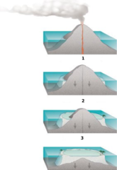
Internationalization of the diagram:Atoll forming. |
| Манбаъ | http://commons.wikimedia.org/wiki/Image:Atoll_forming.jpg |
| Муаллиф | Susan Mayfield and Sara Boore, modified by Eurico Zimbres |
| Иҷозат (Пешроҳандозии ин парванда) |
Free for all use |
| Other versions |
Derivative works of this file: |
Иҷозатнома
This image is in the public domain in the United States because it only contains materials that originally came from the United States Geological Survey, an agency of the United States Department of the Interior. For more information, see the official USGS copyright policy.
|

|
This diagram image could be re-created using vector graphics as an SVG file. This has several advantages; see Commons:Media for cleanup for more information. If an SVG form of this image is available, please upload it and afterwards replace this template with
{{vector version available|new image name}}.
It is recommended to name the SVG file “Atoll forming-i18.svg”—then the template Vector version available (or Vva) does not need the new image name parameter. |
Таърихи файл
Рӯи таърихҳо клик кунед то нусхаи марбути парвандаро бубинед.
| Таърих | Бандангуштӣ | Андоза | Корбар | Тавзеҳ | |
|---|---|---|---|---|---|
| нусхаи феълӣ | 18:32, 29 май 2006 | | 1 667 × 2 423 (486 кбайт) | Zimbres | {{Information |Description= Internationalization of the diagram:Atoll forming.<br> '''1'''=Volcanic Island<br> '''2'''=Fringind reef<br> '''3'''=Barrier reeef<br> |Source=http://commons.wikimedia.org/wiki/Image:Atoll_forming.jpg |Date= |Author=USGS/USGov |
Пайвандҳо
Саҳифаҳои зерин ба ин акс пайванданд:
Истифодаи саросарии парванда
Викиҳои дигари зерин ин файлро истифода мекунанд:
- Истифода дар az.wikipedia.org
- Истифода дар be-tarask.wikipedia.org
- Истифода дар be.wikipedia.org
- Истифода дар es.wikipedia.org
- Истифода дар eu.wikipedia.org
- Истифода дар fi.wikipedia.org
- Истифода дар ja.wikipedia.org
- Истифода дар kbd.wikipedia.org
- Истифода дар lt.wikipedia.org
- Истифода дар mdf.wikipedia.org
- Истифода дар nn.wikipedia.org
- Истифода дар pl.wikipedia.org
- Истифода дар ru.wikipedia.org
- Истифода дар ru.wiktionary.org
- Истифода дар uk.wikipedia.org
- Истифода дар www.wikidata.org