
Акс:Badakhshan districts.png
Андозаи ин пешнамоиш: 800 × 548 пиксел. Дигар кайфиятҳо: 320 × 219 пиксел | 640 × 438 пиксел | 961 × 658 пиксел.
Акси аслӣ ((961 × 658 пиксел, ҳаҷми парванда: 27 кбайт, навъи MIME: image/png))

|
This map image could be re-created using vector graphics as an SVG file. This has several advantages; see Commons:Media for cleanup for more information. If an SVG form of this image is available, please upload it and afterwards replace this template with
{{vector version available|new image name}}.
It is recommended to name the SVG file “Badakhshan districts.svg”—then the template Vector version available (or Vva) does not need the new image name parameter. |
Хулоса
| Тавсифот |
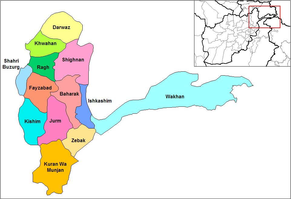
English: Map of the districts of Badakhshan province of Afghanistan. Created by Rarelibra 19:18, 29 March 2007 (UTC) for public domain use, using MapInfo Professional v8.5 and various mapping resources. |
| Сана | 29 Март 2007 (original upload date) |
| Манбаъ | No machine-readable source provided. Own work assumed (based on copyright claims). |
| Муаллиф | No machine-readable author provided. Rarelibra assumed (based on copyright claims). |
Иҷозатнома
| I, the copyright holder of this work, release this work into the public domain. This applies worldwide. In some countries this may not be legally possible; if so: I grant anyone the right to use this work for any purpose, without any conditions, unless such conditions are required by law. |
Таърихи файл
Рӯи таърихҳо клик кунед то нусхаи марбути парвандаро бубинед.
| Таърих | Бандангуштӣ | Андоза | Корбар | Тавзеҳ | |
|---|---|---|---|---|---|
| нусхаи феълӣ | 19:08, 14 Январ 2024 | | 961 × 658 (27 кбайт) | User-duck | Cropped 9 % horizontally, 19 % vertically using CropTool with precise mode. |
| 19:18, 29 марти 2007 |  | 1 056 × 816 (29 кбайт) | Rarelibra | Map of the districts of Badakhshan province of Afghanistan. Created by ~~~~ for public domain use, using MapInfo Professional v8.5 and various mapping resources. |
Пайвандҳо
Ин акс дар ҳеҷ саҳифа истифода намешавад.
Истифодаи саросарии парванда
Викиҳои дигари зерин ин файлро истифода мекунанд:
- Истифода дар ca.wikipedia.org
- Истифода дар de.wikipedia.org
- Истифода дар en.wikipedia.org
- Истифода дар es.wikipedia.org
- Истифода дар et.wikipedia.org
- Истифода дар fr.wikipedia.org
- Истифода дар gl.wikipedia.org
- Истифода дар he.wikipedia.org
- Истифода дар id.wikipedia.org
- Истифода дар incubator.wikimedia.org
- Истифода дар ja.wikipedia.org
- Истифода дар ms.wikipedia.org
- Истифода дар nl.wikipedia.org
- Истифода дар no.wikipedia.org
- Истифода дар pl.wikipedia.org
- Истифода дар pnb.wikipedia.org
- Истифода дар pt.wikipedia.org
- Истифода дар ru.wikipedia.org
- Истифода дар sk.wikipedia.org
- Истифода дар tr.wikipedia.org
View more global usage of this file.