
Акс:Barents Sea map.png
Андозаи ин пешнамоиш: 657 × 600 пиксел. Дигар кайфиятҳо: 263 × 240 пиксел | 526 × 480 пиксел | 841 × 768 пиксел | 1 187 × 1 084 пиксел.
Акси аслӣ ((1 187 × 1 084 пиксел, ҳаҷми парванда: 654 кбайт, навъи MIME: image/png))
Хулоса
| Тавсифот |
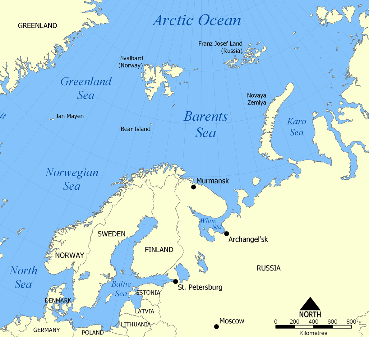
English: The location of the Barents Sea north of Russia and Norway, and the surrounding seas and islands. Also includes political borders with their corresponding nation-states listed. |
| Сана | |
| Манбаъ | Кори худ |
| Муаллиф | NormanEinstein |
| Other versions |
[]
|


Иҷозатнома
I, the copyright holder of this work, hereby publish it under the following licenses:

|
Permission is granted to copy, distribute and/or modify this document under the terms of the GNU Free Documentation License, Version 1.2 or any later version published by the Free Software Foundation; with no Invariant Sections, no Front-Cover Texts, and no Back-Cover Texts. A copy of the license is included in the section entitled GNU Free Documentation License. |
| This file is licensed under the Creative Commons Attribution-Share Alike 3.0 Unported license. | ||
| ||
| This licensing tag was added to this file as part of the GFDL licensing update. |
Шумо иҷозатномаи хостаи худро интихоб карда метавонед.
Таърихи файл
Рӯи таърихҳо клик кунед то нусхаи марбути парвандаро бубинед.
| Таърих | Бандангуштӣ | Андоза | Корбар | Тавзеҳ | |
|---|---|---|---|---|---|
| нусхаи феълӣ | 20:52, 29 марти 2012 | | 1 187 × 1 084 (654 кбайт) | Ras67 | cropped |
| 06:11, 5 феврали 2006 |  | 1 200 × 1 098 (680 кбайт) | Berkut~commonswiki | pngout-ed (13% file size reduction) | |
| 16:40, 25 ноябри 2005 |  | 1 200 × 1 098 (781 кбайт) | NormanEinstein | This map shows the location of the Barents Sea north of Russia and Norway, and the surrounding seas and islands. Created by NormanEinstein, November 25, 2005. {{GFDL-self}} Category:Maps of seas |
Пайвандҳо
Ин акс дар ҳеҷ саҳифа истифода намешавад.
Истифодаи саросарии парванда
Викиҳои дигари зерин ин файлро истифода мекунанд:
- Истифода дар af.wikipedia.org
- Истифода дар ar.wikipedia.org
- Истифода дар arz.wikipedia.org
- Истифода дар ast.wikipedia.org
- Истифода дар azb.wikipedia.org
- Истифода дар bcl.wikipedia.org
- Истифода дар be-tarask.wikipedia.org
- Истифода дар bg.wikipedia.org
- Истифода дар bn.wikipedia.org
- Истифода дар bs.wikipedia.org
- Истифода дар ca.wikipedia.org
- Истифода дар cs.wikipedia.org
- Истифода дар cs.wikinews.org
- Истифода дар da.wikipedia.org
- Истифода дар de.wiktionary.org
- Истифода дар el.wikipedia.org
- Истифода дар en.wikipedia.org
- Barents Sea
- User:NormanEinstein/gallery
- Keith Jessop
- Convoy PQ 18
- Fishing industry in Russia
- Operation Fritham
- List of Russian explorers
- Convoy PQ 12
- Convoy PQ 8
- Arctic naval operations of World War II
- Convoy QP 14
- List of oil and gas fields of the Barents Sea
- Operation Orator
- Operation Gearbox
- Operation Gearbox II
- Atlantification of the Arctic
- Истифода дар en.wikisource.org
- Истифода дар en.wiktionary.org
- Истифода дар eo.wikipedia.org
- Истифода дар es.wikipedia.org
- Истифода дар eu.wikipedia.org
- Истифода дар fa.wikipedia.org
- Истифода дар fi.wikipedia.org
- Истифода дар fo.wikipedia.org
- Истифода дар fr.wikipedia.org
- Истифода дар fr.wikinews.org
- Истифода дар he.wikipedia.org
- Истифода дар hi.wikipedia.org
- Истифода дар hu.wiktionary.org
View more global usage of this file.