
Акс:Cold War Map 1959.png

Акси аслӣ ((1 427 × 628 пиксел, ҳаҷми парванда: 44 кбайт, навъи MIME: image/png))

|
File:Cold War Map 1959.svg is a vector version of this file. It should be used in place of this PNG file when not inferior.
File:Cold War Map 1959.png → File:Cold War Map 1959.svg
For more information, see Help:SVG. |
 |
Хулоса
Colored by Clevelander from public domain Wikimedia Commons source.
01:21, 13 April 2006 . . Clevelander (Talk) . . 1427x628 (38328 bytes)
Copied from the English language wikipedia.
| Maps of world history | |
| BC | |
|
| |
| AD |
1 · 50 · 100 · 200 · 250 · 300 · 400 · 500 · 700 · 750 · 820 · 900 · 1200 · 1500 · 1556 · 1648 · 1700 · 1750 · 1815 · 1859 · 1871 · 1914 · 1935 · 1954 · 1989 · 2000 · |
|
Maps of colonization history | |
|
see also: Eastern Hemisphere only maps template (1300BC-1500AD) | |
| (this template: · view · discuss ) | |
.jpg)
._LOC_2001620596.jpg)
Иҷозатнома
| This file is licensed under the Creative Commons Attribution-Share Alike 3.0 Unported license. Subject to disclaimers. | ||
| ||
| This licensing tag was added to this file as part of the GFDL licensing update. |

|
Permission is granted to copy, distribute and/or modify this document under the terms of the GNU Free Documentation License, Version 1.2 or any later version published by the Free Software Foundation; with no Invariant Sections, no Front-Cover Texts, and no Back-Cover Texts. A copy of the license is included in the section entitled GNU Free Documentation License. Subject to disclaimers. |
Таърихи файл
Рӯи таърихҳо клик кунед то нусхаи марбути парвандаро бубинед.
| Таърих | Бандангуштӣ | Андоза | Корбар | Тавзеҳ | |
|---|---|---|---|---|---|
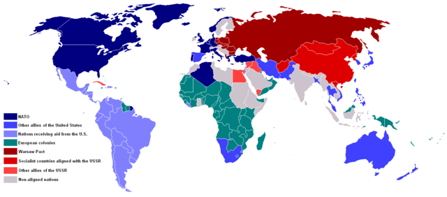
| нусхаи феълӣ | 20:27, 30 Декабри 2014 | | 1 427 × 628 (44 кбайт) | Explorer1492 | Belize and Somaliland changed to colonies, Afghanistan was communist, and added South Yemen to the red side. South Africa was allied to the USA. |
| 15:53, 10 Январ 2013 |  | 800 × 352 (83 кбайт) | Runehelmet | Somalia was since 1950 no longer a Colony of Italy and the UK. | |
| 04:51, 24 июли 2011 |  | 1 427 × 628 (64 кбайт) | Hoshie | added Portuguese Congo (today known as Cabinda in Angola) made changes to Algeria and Fr. Guiana as they were/are DOMs. see talk | |
| 02:58, 27 апрели 2007 |  | 1 427 × 628 (44 кбайт) | Roke~commonswiki | ||
| 02:55, 27 апрели 2007 |  | 1 427 × 628 (44 кбайт) | Roke~commonswiki | add african colonial borders, panama canal, arctic islands, hong kong, goa, sikkim, dutch new guinea, west berlin | |
| 05:10, 12 октябри 2006 |  | 1 427 × 628 (51 кбайт) | Hoshie | fix a few colonies, Bhutan, Ghana based on the CIA Factbook, Walvis Bay, fixed the Yemem boundry. See talk. My mod under same license | |
| 21:00, 29 июли 2006 |  | 1 427 × 628 (65 кбайт) | Ynhockey | Correction - now shows West Bank as part of Jordan (as it was until 1967). | |
| 12:47, 29 апрели 2006 |  | 1 427 × 628 (38 кбайт) | FocalPoint | Colored by Clevelander from public domain Wikimedia Commons source. 01:21, 13 April 2006 . . Clevelander (Talk) . . 1427x628 (38328 bytes) Copied from the English language wikipedia. |
Пайвандҳо
Ин акс дар ҳеҷ саҳифа истифода намешавад.
Истифодаи саросарии парванда
Викиҳои дигари зерин ин файлро истифода мекунанд:
- Истифода дар en.wikipedia.org
- Истифода дар fr.wikipedia.org
- Истифода дар id.wikipedia.org
- Истифода дар it.wikipedia.org
- Истифода дар mg.wikipedia.org
- Истифода дар mr.wikipedia.org
- Истифода дар nl.wikipedia.org
- Истифода дар no.wikipedia.org
- Истифода дар ro.wikipedia.org
- Истифода дар ru.wikipedia.org
- Истифода дар uk.wikipedia.org