
Акс:Florida topographic map-en.svg

Ҳаҷми пешнамоиши PNG барои файли кунунии SVG: 617 × 600 пиксел. Дигар кайфиятҳо: 247 × 240 пиксел | 494 × 480 пиксел | 790 × 768 пиксел | 1 053 × 1 024 пиксел | 2 106 × 2 048 пиксел | 2 890 × 2 810 пиксел.
Акси аслӣ (SVG парванда, исмӣ 2 890 × 2 810 пиксел, андозаи парванда: 2,51 Мбайт)
|

Хулоса
| Description |
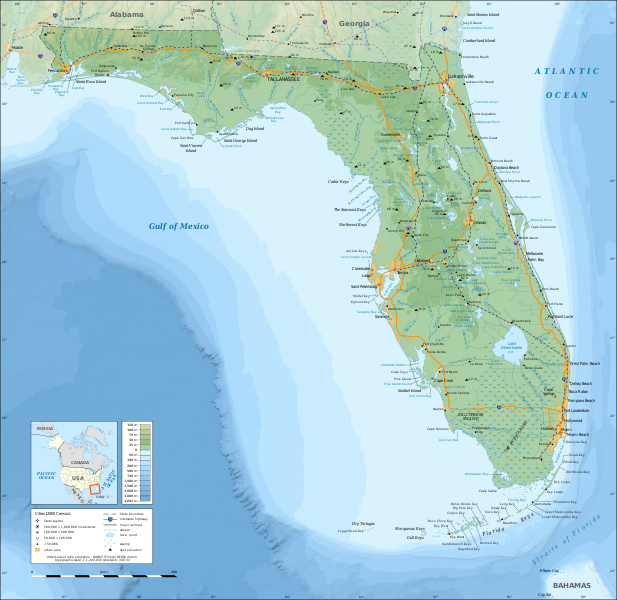
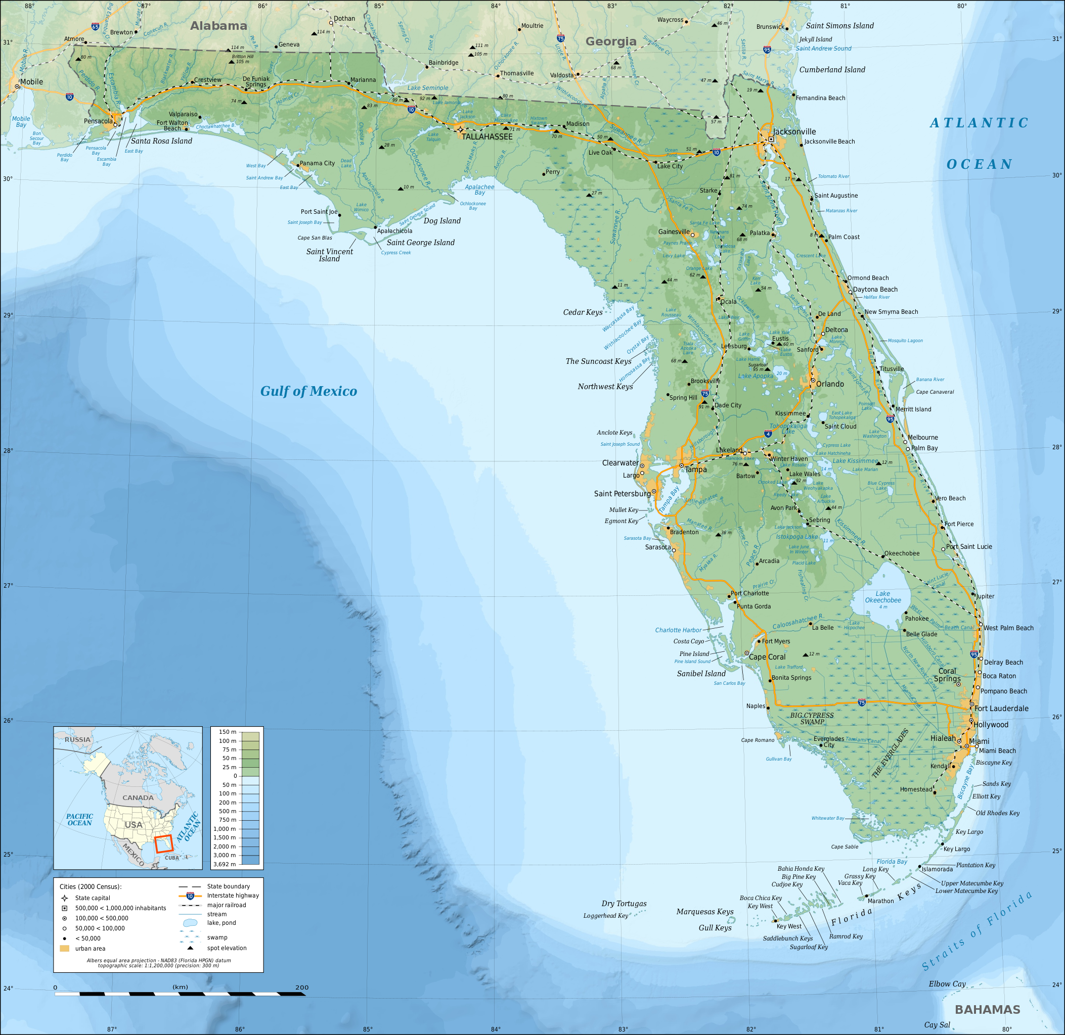
English: Topographic map of the State of Florida, USA (2000 Census).
Note: the background map is a raster image embedded in the SVG file. Español: Mapa topográfico del estado de Florida, Estados Unidos (censo del 2000).
Nota: el fondo del mapa es una imagen incrustada en el archivo SVG. Français : Carte topographique de l'état de Floride, États-Unis (recensement 2000). Note : le fond de carte est une image bitmap embarquée dans le fichier SVG. Albers equal area projection; NAD83 (Florida HPGN) datum |
||
| Сана | |||
| Манбаъ |
Кори худ
|
||
| Падидоваранда | |||
| Иҷозат (Пешроҳандозии ин парванда) |
|
||
| Georeferencing | If inappropriate please set warp_status = skip to hide. | ||
| Other versions |
[]
|


|
This SVG file contains embedded text that can be translated into your language, using any capable SVG editor, text editor or the SVG Translate tool. For more information see: About translating SVG files. |
Иҷозатнома
I, the copyright holder of this work, hereby publish it under the following licenses:

|
Permission is granted to copy, distribute and/or modify this document under the terms of the GNU Free Documentation License, Version 1.2 or any later version published by the Free Software Foundation; with no Invariant Sections, no Front-Cover Texts, and no Back-Cover Texts. A copy of the license is included in the section entitled GNU Free Documentation License. |
This file is licensed under the Creative Commons Attribution-Share Alike Attribution-Share Alike 4.0 International, 3.0 Unported, 2.5 Generic, 2.0 Generic and 1.0 Generic license.
- Шумо озодед:
- мубодилот намудан – копӣ, паҳн ва фиристадани асар
- ремикс кардан – татбиқи кор
- Under the following conditions:
- тахсис – You must give appropriate credit, provide a link to the license, and indicate if changes were made. You may do so in any reasonable manner, but not in any way that suggests the licensor endorses you or your use.
- саҳми яксон – If you remix, transform, or build upon the material, you must distribute your contributions under the same or compatible license as the original.
Шумо иҷозатномаи хостаи худро интихоб карда метавонед.
Таърихи файл
Рӯи таърихҳо клик кунед то нусхаи марбути парвандаро бубинед.
| Таърих | Бандангуштӣ | Андоза | Корбар | Тавзеҳ | |
|---|---|---|---|---|---|
| нусхаи феълӣ | 15:26, 16 Декабри 2008 | | 2 890 × 2 810 (2,51 Мбайт) | Sting | Added summits names |
| 01:34, 15 Декабри 2008 |  | 2 890 × 2 810 (2,51 Мбайт) | Sting | == Summary == {{Information |Description={{en|Topographic map of the State of Florida, USA (2000 Census).<br/>''Note: the background map is a raster image embedded in the SVG file.''} |
Пайвандҳо
Саҳифаҳои зерин ба ин акс пайванданд:
Истифодаи саросарии парванда
Викиҳои дигари зерин ин файлро истифода мекунанд:
- Истифода дар af.wikipedia.org
- Истифода дар ang.wikipedia.org
- Истифода дар arz.wikipedia.org
- Истифода дар az.wikipedia.org
- Истифода дар ban.wikipedia.org
- Истифода дар be.wikipedia.org
- Истифода дар bn.wikipedia.org
- Истифода дар ca.wikipedia.org
- Истифода дар de.wikipedia.org
- Истифода дар el.wikipedia.org
- Истифода дар en.wikipedia.org
- Portal:Geography
- Portal:Geography/Featured picture
- Portal:Florida
- User talk:Sting
- Wikipedia:Graphics Lab/Resources/Tutorials
- Wikipedia:Featured pictures/Diagrams, drawings, and maps/Maps
- Geography of Florida
- Florida
- Wikipedia:WikiProject United States/Recognized content
- Wikipedia:Featured pictures thumbs/26
- Wikipedia:WikiProject United States/Quality content
- User talk:Jujutacular/Archive 9
- Wikipedia:Featured picture candidates/December-2010
- Wikipedia:Featured picture candidates/Topographic map of Florida
- Talk:Geography of Florida
- Template:POTD/2013-03-03
- Portal:Geography/Featured picture/4
- Wikipedia:Picture of the day/March 2013
- User talk:Jujutacular/Archive 15
- Wikipedia:Main Page history/2013 March 3
- User:Abyssal/bla
- Portal:Geography/Selected picture
- Wikipedia:WikiProject United States/Featured pictures
- Истифода дар es.wikipedia.org
- Истифода дар fr.wikipedia.org
- Истифода дар fy.wikipedia.org
- Истифода дар ga.wikipedia.org
- Истифода дар gl.wikipedia.org
- Истифода дар gn.wikipedia.org
- Истифода дар hu.wikipedia.org
- Истифода дар hy.wikipedia.org
- Истифода дар hyw.wikipedia.org
- Истифода дар io.wikipedia.org
View more global usage of this file.