
Акс:Map of the prefectures of Japan with claimed territories.png

Андозаи ин пешнамоиш: 526 × 600 пиксел. Дигар кайфиятҳо: 210 × 240 пиксел | 421 × 480 пиксел | 673 × 768 пиксел | 898 × 1 024 пиксел | 1 397 × 1 593 пиксел.
Акси аслӣ ((1 397 × 1 593 пиксел, ҳаҷми парванда: 115 кбайт, навъи MIME: image/png))
| Тавсифот |
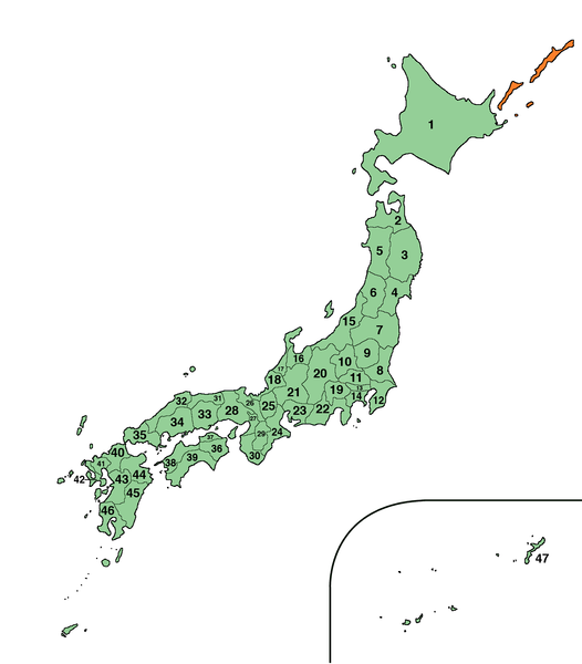
日本語: 日本の位置
Русский: Территория Японии; оспариваемые у России острова окрашены оранжевым
English: Map of Japan with orange colored territories Japan claims toward Russia |
| Сана | (UTC) |
| Манбаъ | |
| Муаллиф |
|
.png)
| This is a retouched picture, which means that it has been digitally altered from its original version. Modifications: changed colour of the claimed territories. The original can be viewed here: Map of the prefectures of Japan (size- large).png:
|
This file is licensed under the Creative Commons Attribution-Share Alike 3.0 Unported license.
- Шумо озодед:
- мубодилот намудан – копӣ, паҳн ва фиристадани асар
- ремикс кардан – татбиқи кор
- Under the following conditions:
- тахсис – You must give appropriate credit, provide a link to the license, and indicate if changes were made. You may do so in any reasonable manner, but not in any way that suggests the licensor endorses you or your use.
- саҳми яксон – If you remix, transform, or build upon the material, you must distribute your contributions under the same or compatible license as the original.
Original upload log
This image is a derivative work of the following images:
- File:Map_of_the_prefectures_of_Japan_(size-_large).png licensed with PD-self
- 2006-12-24T12:15:51Z Kamocsai 1397x1593 (96634 Bytes) Own work based on the image: [[Image:Japan_large.png]]. * JP-01 Hokkaido 北海道 * JP-02 Aomori 青森県 * JP-03 Iwate 岩手県 * JP-04 Miyagi 宮城県 * JP-05 Akita 秋田県 * JP-06 Yamagata 山形県 * JP
Uploaded with derivativeFX
Таърихи файл
Рӯи таърихҳо клик кунед то нусхаи марбути парвандаро бубинед.
| Таърих | Бандангуштӣ | Андоза | Корбар | Тавзеҳ | |
|---|---|---|---|---|---|
| нусхаи феълӣ | 16:51, 6 апрели 2010 | | 1 397 × 1 593 (115 кбайт) | Claymore | {{Information |Description={{ja|1=日本の位置}} {{ru|1=Территория Японии; оспариваемые у России острова окрашены оранжевым}} {{en|1=Map of Japan with orange colored territories Japan claims to |
Пайвандҳо
Ин акс дар ҳеҷ саҳифа истифода намешавад.
Истифодаи саросарии парванда
Викиҳои дигари зерин ин файлро истифода мекунанд:
- Истифода дар ab.wikipedia.org
- Истифода дар be.wikipedia.org
- Истифода дар incubator.wikimedia.org
- Истифода дар ja.wikipedia.org
- 利用者:Yamato
- 利用者:Doraemonplus/Userboc
- 利用者:YOUJI
- 利用者:銀しゃりboy
- 利用者:Shocoreo4212
- 利用者:F.Adler
- 利用者:Reo19950908
- 利用者:要塞騎士
- 利用者:World ryoko/ユーザーボックス研究所
- 利用者:World ryoko/Template:User 47都道府県暗記
- 利用者:Tokuto
- 利用者:霸の寸
- 利用者:疲れてます
- 利用者:Papu
- 利用者:A0108sp
- 利用者:Newstart2012
- 利用者:Masamiti0229
- 利用者:Sekis08
- 利用者:ぽじとろにうむ
- 利用者:A0108sp/sandbox
- 利用者:Daitetu sun
- 利用者:クリンク
- 利用者:ヘイホートリオ
- 利用者:Oruwanwan
- 利用者:下衆の極み
- 利用者:FZ00024wiki
- 利用者:知識熊
- 利用者:Ennpitsu
- 利用者:GeeKay
- 利用者:SanaHiro/自己紹介
- 利用者:超特急
- 利用者:Kochizufan
- 利用者:Fumi37s/第1期
- 利用者:Fumi37s/第6期
- 利用者:Kitakaaho
- 利用者:Fumi37s/第7期
- 利用者:Fumi37s/第8期
- 利用者:Fumi37s/第9期
- 利用者:R-5
- 利用者:TAKGW26
- 利用者:リンク太郎
- 利用者:Clepsilwiki
- 利用者:シャーロット金
- 利用者:無職
- 利用者:三重人
- 利用者:かあらもち
View more global usage of this file.