
Акс:Marshall Islands location map.svg

Ҳаҷми пешнамоиши PNG барои файли кунунии SVG: 634 × 600 пиксел. Дигар кайфиятҳо: 254 × 240 пиксел | 507 × 480 пиксел | 812 × 768 пиксел | 1 082 × 1 024 пиксел | 2 165 × 2 048 пиксел | 780 × 738 пиксел.
Акси аслӣ (SVG парванда, исмӣ 780 × 738 пиксел, андозаи парванда: 101 кбайт)
Хулоса
| Тавсифот |
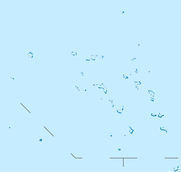
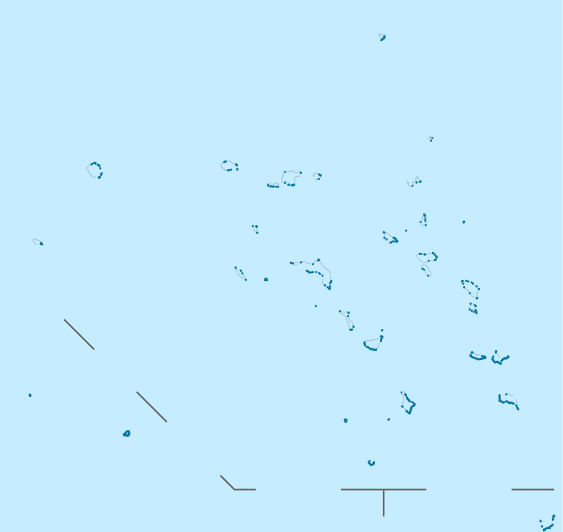
Deutsch: Positionskarte der Marshallinseln
Quadratische Plattkarte. Geographische Begrenzung der Karte:
English: Location map of the Marshall Islands
Equirectangular projection. Geographic limits of the map:
|
| Сана | |
| Манбаъ |
own work, using
|
| Муаллиф | NordNordWest |

|
This map has been made or improved in the German Kartenwerkstatt (Map Lab). You can propose maps to improve as well.
|
Иҷозатнома
I, the copyright holder of this work, hereby publish it under the following licenses:

|
Permission is granted to copy, distribute and/or modify this document under the terms of the GNU Free Documentation License, Version 1.2 or any later version published by the Free Software Foundation; with no Invariant Sections, no Front-Cover Texts, and no Back-Cover Texts. A copy of the license is included in the section entitled GNU Free Documentation License. |
This file is licensed under the Creative Commons Attribution 3.0 Unported license.
- Шумо озодед:
- мубодилот намудан – копӣ, паҳн ва фиристадани асар
- ремикс кардан – татбиқи кор
- Under the following conditions:
- тахсис – You must give appropriate credit, provide a link to the license, and indicate if changes were made. You may do so in any reasonable manner, but not in any way that suggests the licensor endorses you or your use.
Шумо иҷозатномаи хостаи худро интихоб карда метавонед.
Таърихи файл
Рӯи таърихҳо клик кунед то нусхаи марбути парвандаро бубинед.
| Таърих | Бандангуштӣ | Андоза | Корбар | Тавзеҳ | |
|---|---|---|---|---|---|
| нусхаи феълӣ | 19:02, 16 ноябри 2011 | | 780 × 738 (101 кбайт) | NordNordWest | upd |
| 10:33, 17 апрели 2009 |  | 780 × 738 (105 кбайт) | NordNordWest | {{Information |Description= {{de|Positionskarte der Marshallinseln}} Quadratische Plattkarte. Geographische Begrenzung der Karte: * N: 15.5° N * S: 3.0° N * W: 160.0° O * O: 173.2° O {{en|Location map of the [[:en:Marshall Islan |
Пайвандҳо
Саҳифаҳои зерин ба ин акс пайванданд:
Истифодаи саросарии парванда
Викиҳои дигари зерин ин файлро истифода мекунанд:
- Истифода дар af.wikipedia.org
- Истифода дар an.wikipedia.org
- Истифода дар ar.wikipedia.org
- Истифода дар ast.wikipedia.org
- Mayuru
- Roi-Namur
- Módulu:Mapa de llocalización/datos/Islles Márxal
- Atolón de Kwajalein
- Cadena Ralik
- Atolón d'Ailinginae
- Islla Jabat
- Atolón Ebon
- Islla de Lib
- Atolón d'Enewetak
- Atolón de Lae
- Atolón de Jaluit
- Atolón de Namdrik
- Atolón de Namu
- Atolón de Rongerik
- Atolón de Rongelap
- Islla de Kili
- Atolón de Wotho
- Atolón d'Ujae
- Atolón d'Ujelang
- Atolón d'Arno
- Atolón d'Aur
- Atolón de Bokak
- Atolón d'Erikub
- Atolón de Nadikdik
- Pasaxe de Klee
- Islla de Jemo
- Atolón de Bikar
- Islla de Mejit
- Atolón de Wotje
- Atolón de Toke
- Atolón de Likiep
- Atolón d'Ailuk
- Atolón de Maloelap
- Atolón d'Utirik
- Atolón d'Ailinglaplap
- Atolón de Mili
- Runit
- Delap-Uliga-Djarrit
- Aeropuertu Internacional Amata Kabua
- Aeropuertu del Atolón Bikini
- Módulu:Mapa de llocalización/datos/Islles Márxal/usu
- Истифода дар az.wikipedia.org
- Истифода дар ba.wikipedia.org
View more global usage of this file.