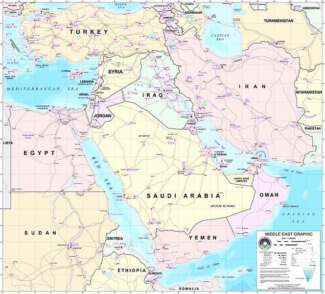
Акс:Middle east graphic 2003.jpg

Андозаи ин пешнамоиш: 664 × 600 пиксел. Дигар кайфиятҳо: 266 × 240 пиксел | 532 × 480 пиксел | 850 × 768 пиксел | 1 134 × 1 024 пиксел | 2 268 × 2 048 пиксел | 2 973 × 2 685 пиксел.
Акси аслӣ ((2 973 × 2 685 пиксел, ҳаҷми парванда: 3,91 Мбайт, навъи MIME: image/jpeg))
Таърихи файл
Рӯи таърихҳо клик кунед то нусхаи марбути парвандаро бубинед.
| Таърих | Бандангуштӣ | Андоза | Корбар | Тавзеҳ | |
|---|---|---|---|---|---|
| нусхаи феълӣ | 22:30, 8 феврали 2012 |  | 2 973 × 2 685 (3,91 Мбайт) | M0tty | Remove compression artefacts by a bilateral filtering. |
| 21:43, 14 июли 2006 |  | 2 973 × 2 685 (1 013 кбайт) | Unquietwiki | ''Courtesy of the University of Texas Libraries, The University of Texas at Austin'' [http://www.lib.utexas.edu/maps/middle_east.html http://www.lib.utexas.edu/maps/middle_east.html] High-resolution political / railway / roadmap of the Middle East. |
Пайвандҳо
Ин акс дар ҳеҷ саҳифа истифода намешавад.
Истифодаи саросарии парванда
Викиҳои дигари зерин ин файлро истифода мекунанд:
- Истифода дар ar.wikipedia.org
- ويكيبيديا:قوالب/بذور
- ويكيبيديا:قوالب/بذور/جدول بذرة 1
- قالب:بذرة جغرافيا الشرق الأوسط
- بادية الشام
- محافظة العاصمة (البحرين)
- خليج عدن
- دزفول
- زاغروس
- مسجد سليمان
- زاينده
- مسرح أحداث الشرق الأوسط خلال الحرب العالمية الثانية
- الحويزة (مدينة)
- قائمة جزر الخليج العربي
- شرق المتوسط
- قائمة نزاعات الشرق الأوسط الحديثة
- مستخدم:Adnanzoom/مساعدات
- عبد الله بن سعيد
- قرار مجلس الأمن التابع للأمم المتحدة رقم 1381
- مستخدم:ASammour/بذرة-بوابة
- شرف الدين بن الحسن
- فخر الدين بن عدي
- صخر بن صخر بن مسافر
- قالب:بذرة أعلام الشرق الأوسط
- أبجر التاسع
- Истифода дар arz.wikipedia.org
- Истифода дар ba.wikipedia.org
- Истифода дар be.wikipedia.org
- Истифода дар bn.wikipedia.org
- Истифода дар ca.wikipedia.org
- Истифода дар ce.wikipedia.org
- Истифода дар ckb.wikipedia.org
- Истифода дар el.wikipedia.org
- Истифода дар en.wikipedia.org
View more global usage of this file.


