
Акс:Relief Map of Latvia.jpg

Андозаи ин пешнамоиш: 800 × 504 пиксел. Дигар кайфиятҳо: 320 × 202 пиксел | 640 × 403 пиксел | 1 200 × 756 пиксел.
Акси аслӣ ((1 200 × 756 пиксел, ҳаҷми парванда: 309 кбайт, навъи MIME: image/jpeg))
Хулоса
| Тавсифот |
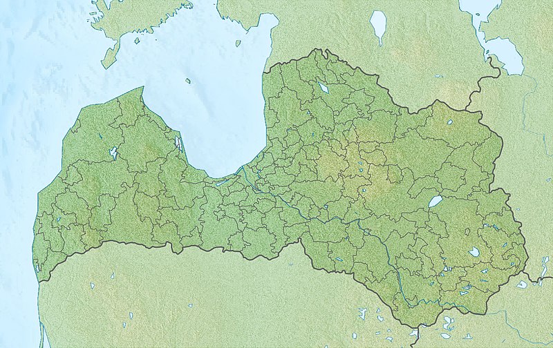
English: Location map of Latvia Equirectangular projection, N/S stretching 170 %. Geographic limits of the map:
|
| Сана | (UTC) |
| Манбаъ |
|
| Муаллиф |
|
| This is a retouched picture, which means that it has been digitally altered from its original version. The original can be viewed here: Latvia location map.svg:
|
Иҷозатнома
I, the copyright holder of this work, hereby publish it under the following licenses:
This file is licensed under the Creative Commons Attribution-Share Alike 3.0 Unported license.
- Шумо озодед:
- мубодилот намудан – копӣ, паҳн ва фиристадани асар
- ремикс кардан – татбиқи кор
- Under the following conditions:
- тахсис – You must give appropriate credit, provide a link to the license, and indicate if changes were made. You may do so in any reasonable manner, but not in any way that suggests the licensor endorses you or your use.
- саҳми яксон – If you remix, transform, or build upon the material, you must distribute your contributions under the same or compatible license as the original.

|
Permission is granted to copy, distribute and/or modify this document under the terms of the GNU Free Documentation License, Version 1.2 or any later version published by the Free Software Foundation; with no Invariant Sections, no Front-Cover Texts, and no Back-Cover Texts. A copy of the license is included in the section entitled GNU Free Documentation License. |
Шумо иҷозатномаи хостаи худро интихоб карда метавонед.
Original upload log
This image is a derivative work of the following images:
- File:Latvia_location_map.svg licensed with Cc-by-sa-3.0, GFDL
- 2009-07-04T13:16:32Z Gleb Borisov 1305x822 (367838 Bytes) from July 1 the political map of Latvia is like that
- 2009-02-12T10:14:18Z NordNordWest 1305x822 (256639 Bytes) boundaries stay the same until July 2009
- 2008-12-31T17:54:15Z NordNordWest 1305x822 (367838 Bytes)
- 2008-08-29T08:07:14Z NordNordWest 1305x822 (256639 Bytes)
- 2008-07-17T21:18:06Z NordNordWest 652x411 (254520 Bytes) {{Information |Description= {{de|Positionskarte von [[:de:Lettland|Lettland]]}} Quadratische Plattkarte, N-S-Streckung 170 %. Geographische Begrenzung der Karte: * N: 58.5° N * S: 55.5° N * W: 20.5° O * O: 28.6° O {{en|Lo
Uploaded with derivativeFX
Таърихи файл
Рӯи таърихҳо клик кунед то нусхаи марбути парвандаро бубинед.
| Таърих | Бандангуштӣ | Андоза | Корбар | Тавзеҳ | |
|---|---|---|---|---|---|
| нусхаи феълӣ | 17:32, 27 ноябри 2010 | | 1 200 × 756 (309 кбайт) | Виктор В | {{Information |Description={{en|Location map of Latvia}} Equirectangular projection, N/S stretching 170 %. Geographic limits of the map: * N: 58.5° N * S: 55.5° N * W: 20.5° E * E: 28.6° E |Source=*[[:File:Latvia_location_map.svg|] |
Пайвандҳо
Саҳифаҳои зерин ба ин акс пайванданд:
Истифодаи саросарии парванда
Викиҳои дигари зерин ин файлро истифода мекунанд:
- Истифода дар an.wikipedia.org
- Истифода дар ar.wikipedia.org
- Истифода дар ast.wikipedia.org
- Истифода дар az.wikipedia.org
- Qauya Milli Parkı
- Şablon:Yer xəritəsi Latviya
- Kemeri Milli Parkı
- Doles yarımadası
- Kolkasraqs burnu
- Teyçi qoruğu
- Venta şəlaləsi
- Slitere Milli Parkı
- Lusavsala
- Latviyanın Milli Botanika Bağı
- Raznas Milli Parkı
- Şimali Vidzeme Biosfer Qoruğu
- Qutman mağarası
- Ventspils Beynəlxalq Radioastronomiya Mərkəzi
- Riqa SES
- Истифода дар bn.wikipedia.org
- Истифода дар bs.wikipedia.org
- Истифода дар ca.wikipedia.org
- Истифода дар ceb.wikipedia.org
- Истифода дар ce.wikipedia.org
- Истифода дар ckb.wikipedia.org
- Истифода дар cs.wikipedia.org
- Истифода дар da.wikipedia.org
- Истифода дар el.wikipedia.org
- Истифода дар en.wikipedia.org
View more global usage of this file.