
Акс:St. John, U.S. Virgin Islands.jpg

Андозаи ин пешнамоиш: 600 × 600 пиксел. Дигар кайфиятҳо: 240 × 240 пиксел | 480 × 480 пиксел | 768 × 768 пиксел | 1 024 × 1 024 пиксел | 2 400 × 2 400 пиксел.
Акси аслӣ ((2 400 × 2 400 пиксел, ҳаҷми парванда: 2,74 Мбайт, навъи MIME: image/jpeg))
Хулоса
| Тавсифот |
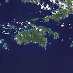
English: Natural-colour image of the Island of St. John island in the United States Virgin Islands.
|
| Сана | |
| Манбаъ | NASA Earth Observatory |
| Муаллиф | Jesse Allen and Robert Simmon |
| Other versions |


.jpg)

Image captured by the Advanced Land Imager (ALI) on NASA’s Earth Observing-1 (EO-1) satellite. EO-1 ALI data provided courtesy of the NASA EO-1 team.
Иҷозатнома
| This file is in the public domain in the United States because it was solely created by NASA. NASA copyright policy states that "NASA material is not protected by copyright unless noted". (See Template:PD-USGov, NASA copyright policy page or JPL Image Use Policy.) | ||
 |
Warnings:
|
| Annotations | This image is annotated: View the annotations at Commons |
Таърихи файл
Рӯи таърихҳо клик кунед то нусхаи марбути парвандаро бубинед.
| Таърих | Бандангуштӣ | Андоза | Корбар | Тавзеҳ | |
|---|---|---|---|---|---|
| нусхаи феълӣ | 10:13, 20 Январ 2011 | | 2 400 × 2 400 (2,74 Мбайт) | Originalwana | {{Information |Description={{en|1=Natural-colour image of the eastern half of St. John. Settlements—marked by curving roads and light roofs—line the irregular coastline. The pinpoints of white in Coral Bay are probably boats. The island’s interior |
Пайвандҳо
Саҳифаҳои зерин ба ин акс пайванданд:
Истифодаи саросарии парванда
Викиҳои дигари зерин ин файлро истифода мекунанд:
- Истифода дар arz.wikipedia.org
- Истифода дар ast.wikipedia.org
- Истифода дар ca.wikipedia.org
- Истифода дар ceb.wikipedia.org
- Истифода дар cy.wikipedia.org
- Истифода дар en.wikipedia.org
- Истифода дар en.wikisource.org
- Истифода дар eo.wikipedia.org
- Истифода дар es.wikipedia.org
- Истифода дар eu.wikipedia.org
- Истифода дар fi.wikipedia.org
- Истифода дар frr.wikipedia.org
- Истифода дар fr.wikivoyage.org
- Истифода дар gl.wikipedia.org
- Истифода дар id.wikipedia.org
- Истифода дар lb.wikipedia.org
- Истифода дар pl.wikipedia.org
- Истифода дар tl.wikipedia.org
- Истифода дар uk.wikipedia.org
- Истифода дар vec.wikipedia.org
- Истифода дар www.wikidata.org