
Акс:Torpedoed Japanese destroyer Yamakaze sinking on 25 June 1942.jpg

Андозаи ин пешнамоиш: 759 × 599 пиксел. Дигар кайфиятҳо: 304 × 240 пиксел | 608 × 480 пиксел | 973 × 768 пиксел | 1 280 × 1 011 пиксел | 2 560 × 2 021 пиксел | 2 937 × 2 319 пиксел.
Акси аслӣ ((2 937 × 2 319 пиксел, ҳаҷми парванда: 3,84 Мбайт, навъи MIME: image/jpeg))
Хулоса
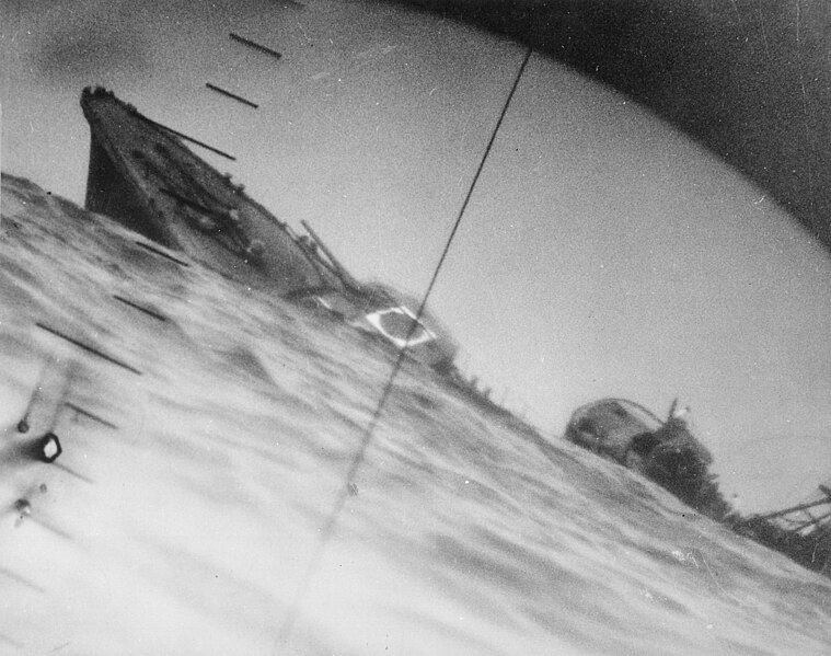
| Тавсифот | Sinking of the Japanese destroyer Yamakaze on 25 June 1942 approximately 110 km southeast of Yokosuku, Japan, photographed through the periscope of the U.S. Navy submarine USS Nautilus (SS-168). This position is given in The Official Chronology of the U.S. Navy in World War II by Robert Cressman. NH 111751 says 75 miles southwest of Yokahama Harbor. Yokahama is near Yokosuku. | |||
| Сана | ||||
| Манбаъ |
|
|||
| Муаллиф | U.S. Navy | |||
| Other versions | Official U.S. Navy photo NH 111751 from the U.S. Navy Naval History and Heritage Command |
| Camera location | | View this and other nearby images on: OpenStreetMap |
|---|
|
Иҷозатнома
This file is a work of a sailor or employee of the U.S. Navy, taken or made as part of that person's official duties. As a work of the U.S. federal government, it is in the public domain in the United States.
|
 | |
| This file has been identified as being free of known restrictions under copyright law, including all related and neighboring rights. | ||
Таърихи файл
Рӯи таърихҳо клик кунед то нусхаи марбути парвандаро бубинед.
| Таърих | Бандангуштӣ | Андоза | Корбар | Тавзеҳ | |
|---|---|---|---|---|---|
| нусхаи феълӣ | 06:37, 9 октябри 2016 | | 2 937 × 2 319 (3,84 Мбайт) | Cobatfor | new NHHC file |
| 20:55, 21 августи 2007 |  | 2 985 × 2 048 (1,5 Мбайт) | BrokenSphere | == Summary == {{Information |Description=Torpedoed Japanese destroyer photographed through periscope of U.S.S. Wahoo or U.S.S. Nautilus, June 1942. (Navy) Exact Date Shot Unknown NARA FILE #: 080-G-418331 WAR & CONFLICT BOOK #: 1315 |Source=High resolutio |
Пайвандҳо
Саҳифаҳои зерин ба ин акс пайванданд:
Истифодаи саросарии парванда
Викиҳои дигари зерин ин файлро истифода мекунанд:
- Истифода дар ar.wikipedia.org
- Истифода дар azb.wikipedia.org
- Истифода дар bg.wikipedia.org
- Истифода дар bn.wikipedia.org
- Истифода дар ca.wikipedia.org
- Истифода дар cs.wikipedia.org
- Истифода дар en.wikipedia.org
- Periscope
- Pacific War
- USS Nautilus (SS-168)
- Salmon-class submarine
- Japanese destroyer Yamakaze (1936)
- Talk:Japanese destroyer Yamakaze (1936)
- Wikipedia:Featured pictures/History/World War II
- Allied submarines in the Pacific War
- List of shipwrecks in June 1942
- User talk:TomStar81/Archive 17
- Wikipedia:Featured pictures thumbs/51
- Wikipedia:Featured picture candidates/The death of the Imperial Japanese Destroyer Yamakaze as seen through the periscope of the submarine USS Nautilus (SS-168)
- Wikipedia:Featured picture candidates/April-2015
- Wikipedia:WikiProject Military history/News/May 2015/Articles
- Wikipedia:Wikipedia Signpost/2015-04-15/Featured content
- Wikipedia:Wikipedia Signpost/Single/2015-04-15
- List of maritime disasters in World War II
- Template:POTD/2018-06-25
- Wikipedia:Picture of the day/June 2018
- Wikipedia:Main Page history/2018 June 25
- User:Hughseyfort/sandbox
- Истифода дар es.wikipedia.org
- Истифода дар eu.wikipedia.org
- Истифода дар fa.wikipedia.org
- Истифода дар fi.wikipedia.org
- Истифода дар fr.wikipedia.org
- Истифода дар hu.wikipedia.org
- Истифода дар id.wikipedia.org
- Истифода дар it.wikipedia.org
- Истифода дар ja.wikipedia.org
View more global usage of this file.