
Акс:Urartu 743-en.svg

Ҳаҷми пешнамоиши PNG барои файли кунунии SVG: 800 × 513 пиксел. Дигар кайфиятҳо: 320 × 205 пиксел | 640 × 410 пиксел | 1 024 × 657 пиксел | 1 280 × 821 пиксел | 2 560 × 1 641 пиксел | 2 714 × 1 740 пиксел.
Акси аслӣ (SVG парванда, исмӣ 2 714 × 1 740 пиксел, андозаи парванда: 850 кбайт)
Хулоса
| Тавсифот |
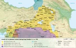
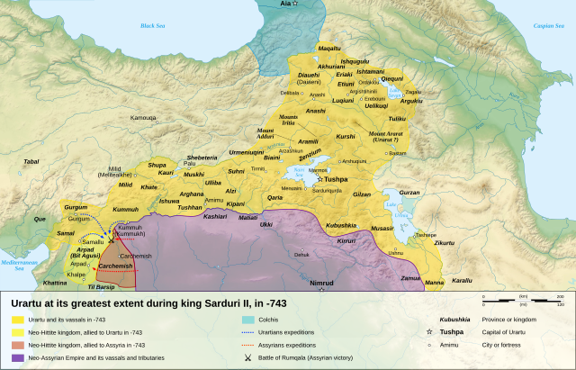
English: Map of the kingdom of Urartu at its greatest extent, in -743.
Français : Carte en anglais du royaume d'Urartu à son apogée, en -743. |
| Сана | |
| Манбаъ |
Кори худ (Original text: Own work. ) Sources :
Software used :
Other data :
|
| Муаллиф | Sémhur |
| Other versions |
See Urartu.
|
| Тахсис (required by the license) | © Sémhur / Wikimedia Commons / |
| SVG genesis |

| Camera location | | View this and other nearby images on: OpenStreetMap |
|---|
Иҷозатнома
Sémhur, the copyright holder of this work, hereby publishes it under the following licenses:
| Copyleft: This work of art is free; you can redistribute it and/or modify it according to terms of the Free Art License. You will find a specimen of this license on the Copyleft Attitude site as well as on other sites. |
This file is licensed under the Creative Commons Attribution-Share Alike Attribution-Share Alike 4.0 International, 3.0 Unported, 2.5 Generic, 2.0 Generic and 1.0 Generic license.
Тахсис: Sémhur
- Шумо озодед:
- мубодилот намудан – копӣ, паҳн ва фиристадани асар
- ремикс кардан – татбиқи кор
- Under the following conditions:
- тахсис – You must give appropriate credit, provide a link to the license, and indicate if changes were made. You may do so in any reasonable manner, but not in any way that suggests the licensor endorses you or your use.
- саҳми яксон – If you remix, transform, or build upon the material, you must distribute your contributions under the same or compatible license as the original.
Шумо иҷозатномаи хостаи худро интихоб карда метавонед.
Таърихи файл
Рӯи таърихҳо клик кунед то нусхаи марбути парвандаро бубинед.
| Таърих | Бандангуштӣ | Андоза | Корбар | Тавзеҳ | |
|---|---|---|---|---|---|
| нусхаи феълӣ | 19:08, 27 апрели 2024 | | 2 714 × 1 740 (850 кбайт) | Sémhur | + Tirmiti (https://www.academia.edu/8830071) |
| 16:09, 10 Январ 2008 |  | 2 714 × 1 740 (859 кбайт) | Sémhur | == Description == {{Information |Description= {{en| Map of the kingdom of Urartu at its greatest extent, in -743.}} {{fr| Carte en anglais du royaume d'Urartu à son apogée, en -743.}} |Source=Own work. {{clr}} Sources : * Topographic background : [http: |
Пайвандҳо
Ин акс дар ҳеҷ саҳифа истифода намешавад.
Истифодаи саросарии парванда
Викиҳои дигари зерин ин файлро истифода мекунанд:
- Истифода дар el.wikipedia.org
- Истифода дар en.wikipedia.org
- Истифода дар hu.wikipedia.org
- Истифода дар hy.wikipedia.org
- Истифода дар ja.wikipedia.org
- Истифода дар mk.wikipedia.org
- Истифода дар mn.wikipedia.org
- Истифода дар ms.wikipedia.org
- Истифода дар mt.wikipedia.org
- Истифода дар no.wikipedia.org
- Истифода дар pl.wikipedia.org
- Истифода дар simple.wikipedia.org
- Истифода дар si.wikipedia.org
- Истифода дар xmf.wikipedia.org