
Акс:Achaemenid Empire 500 BC.png

Андозаи ин пешнамоиш: 800 × 427 пиксел. Дигар кайфиятҳо: 320 × 171 пиксел | 640 × 341 пиксел | 1 024 × 546 пиксел | 1 280 × 683 пиксел | 3 070 × 1 637 пиксел.
Акси аслӣ ((3 070 × 1 637 пиксел, ҳаҷми парванда: 811 кбайт, навъи MIME: image/png))
Хулоса
| Тавсифот |
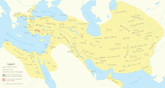
English: A map of the Achaemenid Empire around 500 BC featuring ancient regions, settlements and Satrapies. This map assembles information from the Historischer Schul-Atlas zur alten, mittleren und neueren Geschichte by Heinrich Kiepert and Carl Wolff from 1879 as accessed from GEI Digital, the 1923 edition of Historical Atlas by William R. Shepherd as accessed from the Perry-Castañeda Library's online map collection and Livius.org's article on the Satrapies of the Achaemenid Empire according to Herodotus. |
| Сана | |
| Манбаъ | Кори худ |
| Муаллиф | Cattette |
Иҷозатнома
I, the copyright holder of this work, hereby publish it under the following license:
This file is licensed under the Creative Commons Attribution 4.0 International license.
- Шумо озодед:
- мубодилот намудан – копӣ, паҳн ва фиристадани асар
- ремикс кардан – татбиқи кор
- Under the following conditions:
- тахсис – You must give appropriate credit, provide a link to the license, and indicate if changes were made. You may do so in any reasonable manner, but not in any way that suggests the licensor endorses you or your use.
Таърихи файл
Рӯи таърихҳо клик кунед то нусхаи марбути парвандаро бубинед.
| Таърих | Бандангуштӣ | Андоза | Корбар | Тавзеҳ | |
|---|---|---|---|---|---|
| нусхаи феълӣ | 07:01, 12 марти 2021 | | 3 070 × 1 637 (811 кбайт) | Cattette | Changed terminology, added Cyropolis |
| 06:05, 9 марти 2021 |  | 3 070 × 1 637 (811 кбайт) | Cattette | Added more cities | |
| 21:52, 8 марти 2021 |  | 3 070 × 1 637 (807 кбайт) | Cattette | Removed anachronistic labels, removed Thrace and Macedonia as Satrapies | |
| 20:44, 8 марти 2021 |  | 3 070 × 1 637 (813 кбайт) | Cattette | Fixed north eastern border, tweaked satrapies | |
| 18:55, 8 марти 2021 |  | 3 070 × 1 637 (794 кбайт) | Cattette | Tweaked borders and satraps | |
| 15:20, 8 марти 2021 |  | 3 070 × 1 637 (789 кбайт) | Cattette | Fixed Indian border again, added cities in Greece | |
| 07:02, 8 марти 2021 |  | 3 070 × 1 637 (785 кбайт) | Cattette | Stronger color, capitals, more cities, added Indian territories beyond the Indus | |
| 14:26, 7 марти 2021 |  | 2 923 × 1 637 (729 кбайт) | Cattette | Uploaded own work with UploadWizard |
Пайвандҳо
Саҳифаҳои зерин ба ин акс пайванданд:
Истифодаи саросарии парванда
Викиҳои дигари зерин ин файлро истифода мекунанд:
- Истифода дар arz.wikipedia.org
- Истифода дар ast.wikipedia.org
- Истифода дар ceb.wikipedia.org
- Истифода дар cs.wikipedia.org
- Истифода дар en.wikipedia.org
- Истифода дар fa.wikipedia.org
- Истифода дар ga.wikipedia.org
- Истифода дар gl.wikipedia.org
- Истифода дар ha.wikipedia.org
- Истифода дар he.wikipedia.org
- Истифода дар ko.wikipedia.org
- Истифода дар ku.wikipedia.org
- Истифода дар pl.wikipedia.org
- Истифода дар www.wikidata.org