
Акс:Orissa State map.svg

Ҳаҷми пешнамоиши PNG барои файли кунунии SVG: 740 × 599 пиксел. Дигар кайфиятҳо: 296 × 240 пиксел | 593 × 480 пиксел | 948 × 768 пиксел | 1 264 × 1 024 пиксел | 2 529 × 2 048 пиксел | 2 184 × 1 769 пиксел.
Акси аслӣ (SVG парванда, исмӣ 2 184 × 1 769 пиксел, андозаи парванда: 1,77 Мбайт)
Хулоса
| Унвони мақола |
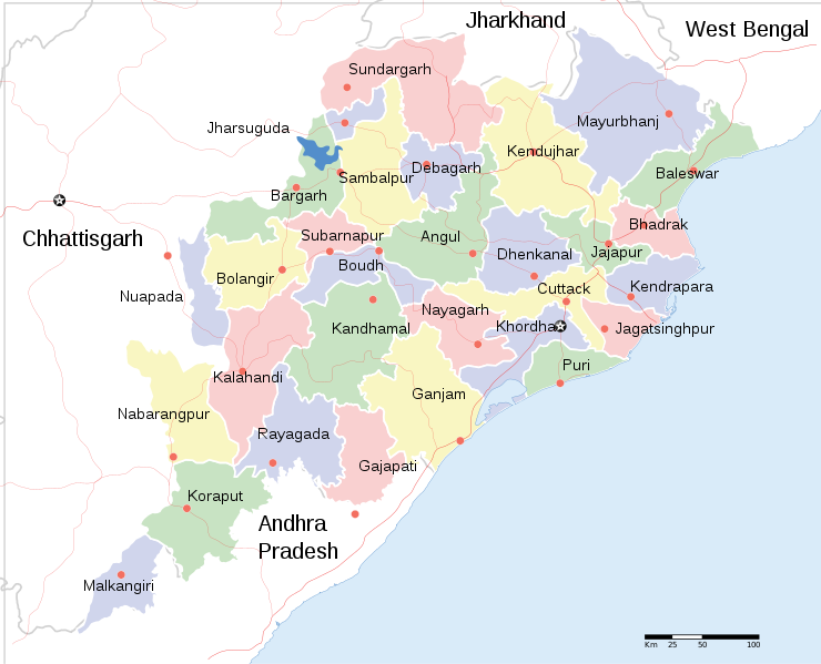
English: Locator map of Indian state, Odisha. |
| Description |
Locator map of the state of Orissa, India with district boundaries. |
| Сана | |
| Манбаъ |
Кори худ |
| Падидоваранда | |
| Иҷозат (Пешроҳандозии ин парванда) |
I, the copyright holder of this work, hereby publish it under the following license: This file is licensed under the Creative Commons Attribution-Share Alike 3.0 Unported license.
|
| Geotemporal data | |
| Date depicted | second half of 20 century ва 21 century |
| Georeferencing | If inappropriate please set warp_status = skip to hide. |
| Archival data | |
| Эзоҳот | Part of WikiProject India Maps |
| Other versions |
[]
|


Таърихи файл
Рӯи таърихҳо клик кунед то нусхаи марбути парвандаро бубинед.
| Таърих | Бандангуштӣ | Андоза | Корбар | Тавзеҳ | |
|---|---|---|---|---|---|
| нусхаи феълӣ | 20:18, 10 июни 2020 | | 2 184 × 1 769 (1,77 Мбайт) | শরদিন্দু ভট্টাচার্য্য | File uploaded using svgtranslate tool (https://svgtranslate.toolforge.org/). Added translation for bn. |
| 09:35, 1 апрели 2011 |  | 2 184 × 1 769 (1,76 Мбайт) | Jayantanth | == {{int:filedesc}} == {{WikiProject_India_Maps |Title=Orissa locator map |Description=Locator map of the state of Orissa, India with district boundaries. |Source= |Date=2008-12-29 |Author={{User:PlaneMad/Info}} }} [[Category:WikiPr |
Пайвандҳо
Саҳифаҳои зерин ба ин акс пайванданд:
Истифодаи саросарии парванда
Викиҳои дигари зерин ин файлро истифода мекунанд:
- Истифода дар bcl.wikipedia.org
- Истифода дар bn.wikipedia.org
- Истифода дар cv.wikipedia.org
- Истифода дар en.wikipedia.org
- Истифода дар fa.wikipedia.org
- Истифода дар fr.wikipedia.org
- Истифода дар ha.wikipedia.org
- Истифода дар hr.wikipedia.org
- Истифода дар hy.wikipedia.org
- Истифода дар it.wikipedia.org
- Истифода дар mai.wikipedia.org
- Истифода дар ml.wikipedia.org
- Истифода дар mn.wikipedia.org
- Истифода дар ne.wikipedia.org
- Истифода дар pa.wikipedia.org
- Истифода дар ru.wikipedia.org
- Истифода дар sa.wikipedia.org
- Истифода дар sd.wikipedia.org
- Истифода дар ur.wikipedia.org
- Истифода дар zh.wikipedia.org
View more global usage of this file.