
Акс:Map of Franz Josef Land-en.svg

Ҳаҷми пешнамоиши PNG барои файли кунунии SVG: 800 × 535 пиксел. Дигар кайфиятҳо: 320 × 214 пиксел | 640 × 428 пиксел | 1 024 × 685 пиксел | 1 280 × 856 пиксел | 2 560 × 1 712 пиксел | 1 289 × 862 пиксел.
Акси аслӣ (SVG парванда, исмӣ 1 289 × 862 пиксел, андозаи парванда: 719 кбайт)
Хулоса
| Тавсифот |
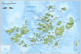
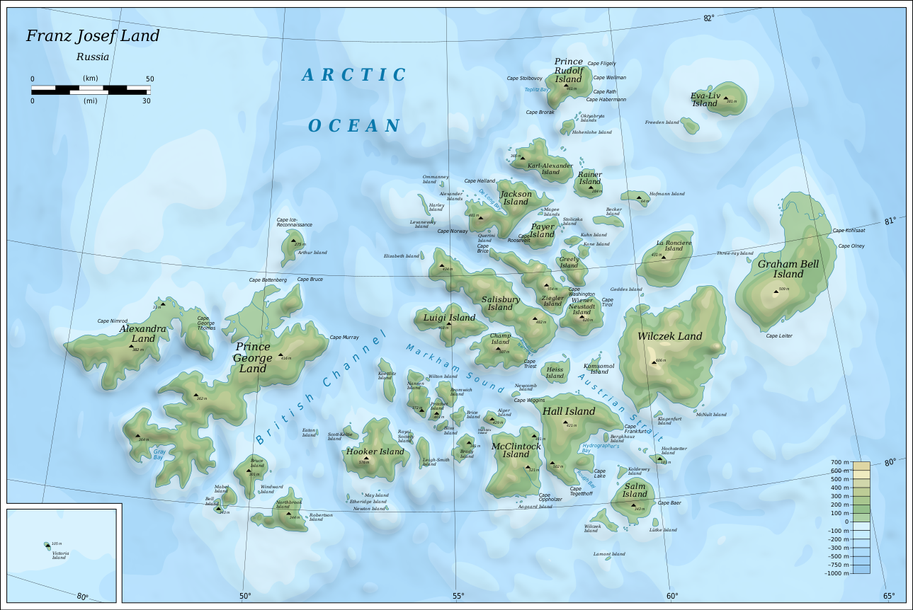
English: Map of Franz Josef Land of Russia. |
| Сана | |
| Манбаъ |
Own work using: Inkscape.
|
| Муаллиф | Oona Räisänen |
| Other versions |
|
| SVG genesis |


Иҷозатнома
I, the copyright holder of this work, hereby publish it under the following licenses:
This file is licensed under the Creative Commons Attribution-Share Alike 3.0 Unported license.
- Шумо озодед:
- мубодилот намудан – копӣ, паҳн ва фиристадани асар
- ремикс кардан – татбиқи кор
- Under the following conditions:
- тахсис – You must give appropriate credit, provide a link to the license, and indicate if changes were made. You may do so in any reasonable manner, but not in any way that suggests the licensor endorses you or your use.
- саҳми яксон – If you remix, transform, or build upon the material, you must distribute your contributions under the same or compatible license as the original.

|
Permission is granted to copy, distribute and/or modify this document under the terms of the GNU Free Documentation License, Version 1.2 or any later version published by the Free Software Foundation; with no Invariant Sections, no Front-Cover Texts, and no Back-Cover Texts. A copy of the license is included in the section entitled GNU Free Documentation License. |
Шумо иҷозатномаи хостаи худро интихоб карда метавонед.
Таърихи файл
Рӯи таърихҳо клик кунед то нусхаи марбути парвандаро бубинед.
| Таърих | Бандангуштӣ | Андоза | Корбар | Тавзеҳ | |
|---|---|---|---|---|---|
| нусхаи феълӣ | 06:05, 12 августи 2019 | | 1 289 × 862 (719 кбайт) | Cherkash | fixed some objects: names spelling, location |
| 14:24, 28 октябри 2010 |  | 1 289 × 862 (719 кбайт) | Mysid | shading + fixes | |
| 19:21, 26 октябри 2010 |  | 1 289 × 862 (719 кбайт) | Mysid | bigger fonts | |
| 19:13, 26 октябри 2010 |  | 1 289 × 862 (718 кбайт) | Mysid | {{Information |Description={{en|1=Map of en:Franz Josef Land of Russia.}} |Source={{own}}. Self-made in Inkscape. Topography and shoreline manually derived from a 1964 map by United States Army Map Service, Corps of Engineers ([[:File:NU-38-39-40-41 |
Пайвандҳо
Саҳифаҳои зерин ба ин акс пайванданд:
Истифодаи саросарии парванда
Викиҳои дигари зерин ин файлро истифода мекунанд:
- Истифода дар af.wikipedia.org
- Истифода дар ar.wikipedia.org
- Истифода дар avk.wikipedia.org
- Wilczek (ewala)
- Teza:FranzJosefTursia
- Salm (ewala)
- Lütke (ewala)
- Hochstetter (ewala)
- Wilczek (ewalama)
- Schönau (ewala)
- Koldewey (ewala)
- Hall (ewala)
- Berghaus (ewala)
- McClintock (ewala)
- Heiss (ewala)
- Komsomol (ewala)
- Newcomb (ewala)
- Alger (ewala)
- Brice (ewala)
- Brady (ewala)
- Bliss (ewala)
- Nansen (ewala)
- Pritchett (ewala)
- Bromwich (ewala)
- Koettlitz (ewala)
- Hooker (ewala)
- Scott-Keltie (ewala)
- Royal Society (ewala)
- Leigh-Smith (ewala)
- Luigi (ewala)
- Salisbury (ewala)
- Champ (ewala)
- Ziegler (ewala)
- Wiener Neustadt (ewala)
- Franz-Josef (tursia)
- Greely (ewala)
- Kane (ewala)
- Kuhn (ewala)
- Payer (ewala)
- Jackson (ewala)
- Karl-Alexander (ewala)
- Rainer (ewala)
- Hohenlohe (ewala)
- Prince Rudolf (ewala)
- La Roncière (ewala)
- Becker (ewala)
- Hofmann (ewala)
- Freeden (ewala)
- Eva-Liv (ewala)
- Graham Bell (ewala)
- Bruce (ewala)
View more global usage of this file.