
Акс:Iran location map.svg

Ҳаҷми пешнамоиши PNG барои файли кунунии SVG: 672 × 600 пиксел. Дигар кайфиятҳо: 269 × 240 пиксел | 538 × 480 пиксел | 861 × 768 пиксел | 1 147 × 1 024 пиксел | 2 295 × 2 048 пиксел | 1 200 × 1 071 пиксел.
Акси аслӣ (SVG парванда, исмӣ 1 200 × 1 071 пиксел, андозаи парванда: 299 кбайт)
Хулоса
| Тавсифот |
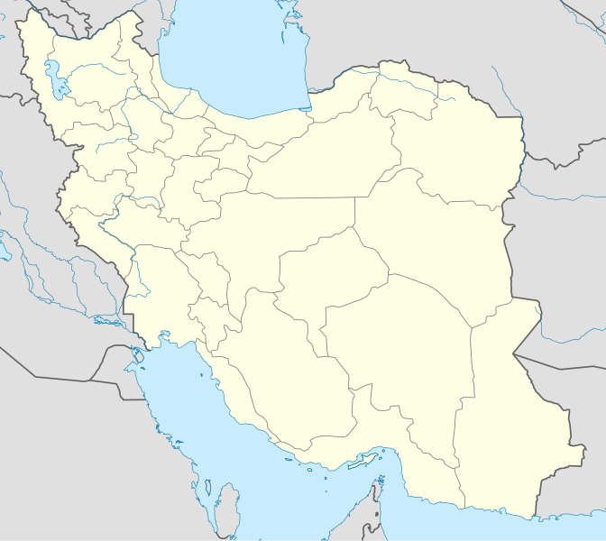
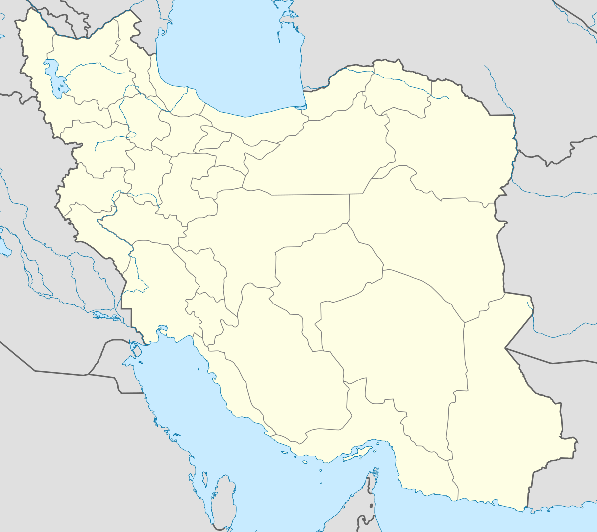
English: Location map of Iran.
Equirectangular projection. Stretched by 118.0%. Geographic limits of the map: * N: 40.0° N * S: 24.5° N * W: 43.5° E * E: 64.0° EMade with Natural Earth. Free vector and raster map data @ naturalearthdata.com. |
| Сана | |
| Манбаъ | Кори худ |
| Муаллиф | Uwe Dedering |
| Other versions |
Derivative works of this file:
|
| SVG genesis | This W3C-invalid map was created with Adobe Illustrator, and with Inkscape. |

Иҷозатнома
I, the copyright holder of this work, hereby publish it under the following licenses:
This file is licensed under the Creative Commons Attribution-Share Alike 3.0 Unported license.
- Шумо озодед:
- мубодилот намудан – копӣ, паҳн ва фиристадани асар
- ремикс кардан – татбиқи кор
- Under the following conditions:
- тахсис – You must give appropriate credit, provide a link to the license, and indicate if changes were made. You may do so in any reasonable manner, but not in any way that suggests the licensor endorses you or your use.
- саҳми яксон – If you remix, transform, or build upon the material, you must distribute your contributions under the same or compatible license as the original.

|
Permission is granted to copy, distribute and/or modify this document under the terms of the GNU Free Documentation License, Version 1.2 or any later version published by the Free Software Foundation; with no Invariant Sections, no Front-Cover Texts, and no Back-Cover Texts. A copy of the license is included in the section entitled GNU Free Documentation License. |
Шумо иҷозатномаи хостаи худро интихоб карда метавонед.
Таърихи файл
Рӯи таърихҳо клик кунед то нусхаи марбути парвандаро бубинед.
| Таърих | Бандангуштӣ | Андоза | Корбар | Тавзеҳ | |
|---|---|---|---|---|---|
| нусхаи феълӣ | 07:59, 22 октябри 2013 | | 1 200 × 1 071 (299 кбайт) | NordNordWest | Reverted to version as of 17:55, 15 April 2013; no reason for change given |
| 13:44, 21 октябри 2013 |  | 1 200 × 1 071 (640 кбайт) | Ekivalan | Reverted to version as of 17:38, 12 April 2013 | |
| 13:43, 21 октябри 2013 |  | 1 200 × 1 071 (640 кбайт) | Ekivalan | Reverted to version as of 17:38, 12 April 2013 | |
| 17:55, 15 апрели 2013 |  | 1 200 × 1 071 (299 кбайт) | NordNordWest | according to http://images.persianblog.ir/516041_B0b76ypr.jpg + Tabas -> South Khorasan province | |
| 17:40, 12 апрели 2013 |  | 1 200 × 1 071 (640 кбайт) | Yamaha5 | Reverted to version as of 20:08, 11 July 2010 | |
| 17:38, 12 апрели 2013 |  | 1 200 × 1 071 (640 кбайт) | Yamaha5 | Reverted to version as of 20:08, 11 July 2010 in all maps khorasan is like past! | |
| 11:30, 17 марти 2013 |  | 1 200 × 1 071 (294 кбайт) | NordNordWest | upd | |
| 20:08, 11 июли 2010 |  | 1 200 × 1 071 (640 кбайт) | Uwe Dedering | 31. province Alborz | |
| 17:44, 18 феврали 2010 |  | 1 200 × 1 071 (705 кбайт) | Uwe Dedering | Bahrain above water, no disputed countries | |
| 13:00, 18 феврали 2010 |  | 1 200 × 1 071 (709 кбайт) | Uwe Dedering | {{Information |Description={{en|1=Location map of Iran. Equirectangular projection. Strechted by 118.0%. Geographic limits of the map: * N: 40.0° N * S: 24.5° N * W: 43.5° E * E: 64.0° E Made with Natural Earth. Free vector and raster map data @ |
Пайвандҳо
More than 100 pages use this file. The following list shows the first 100 pages that use this file only. A full list is available.
- Аваз (Форс)
- Акбаробод (Эрон)
- Алиободи Демеқ
- Алиободи Пуштишаҳр
- Арад (Эрон)
- Араквоз
- Ардабил
- Ардакон (Форс)
- Асадобод
- Аҳвоз
- Бандар Аббос
- Бандари Дайлам
- Бандари Хумайнӣ
- Безин (Шероз)
- Бейрам
- Боноруйе
- Бошт
- Веноӣ
- Галеҳдор
- Гатванд
- Гачсорон
- Гийон
- Гуйям
- Деҳдашт (Эрон)
- Дилгуша
- Дориён (Форс)
- Зоҳидон
- Зоҳидшаҳр
- Истаҳбон
- Иштиҳорд
- Калебар
- Канора (Марвдашт)
- Кевор
- Кунортахта
- Ланде
- Латифӣ (Форс)
- Ликак
- Лолеҷин
- Лолӣ
- Марвдашт
- Марйонеҷ
- Маҳобод
- Мейманд
- Меҳриён
- Мишкиндашт
- Миёнрӯд
- Миҳр
- Модувони Олиё
- Мосур
- Моҳдашт
- Муллосонӣ
- Мурмури
- Муҳаммадшаҳр
- Наҷафобод
- Нуробод (Форс)
- Ободон
- Омидийе
- Ошторинон
- Рай
- Рашт (Эрон)
- Ромшир
- Сайидан
- Сайидон
- Саодатшаҳр (Форс)
- Сарвистон
- Сафияобод
- Сафошаҳр
- Серобтова
- Сисехт
- Сусенгерд
- Тӯс
- Фардис
- Фарошбанд
- Хешт
- Хонҷ
- Хурмавҷ
- Шайбон
- Шаҳраки Толеқони
- Шаҳри Пир
- Эзадхост
- Эроншаҳр
- Қарвейи Дарҷазин
- Қасри Ширин
- Қасри Қумиша
- Қир (Форс)
- Қодиробод (Форс)
- Қоимийе
- Қосимобод (Ҳамадон)
- Қутбобод
- Ҳамидия
- Ҳандиҷон
- Ҳафтгил
- Ҳоҷиобод
- Ҳувийзе
- Ҷаводийя (Форс)
- Ҷам
- Ҷаннатшаҳр
- Ҷаҳонобод, Луристон
- Ҷойдашт (Форс)
- Ҷулфо
View more links to this file.
Истифодаи саросарии парванда
Викиҳои дигари зерин ин файлро истифода мекунанд:
- Истифода дар af.wikipedia.org
- Истифода дар als.wikipedia.org
- Истифода дар an.wikipedia.org
- Истифода дар ar.wikipedia.org
- محمد بن إسماعيل البخاري
- طهران
- صحيح مسلم
- محافظات إيران
- فخر الدين الرازي
- كأس آسيا 1968
- كأس آسيا 1976
- مسلم بن الحجاج
- قالب:خريطة مواقع إیران
- مشهد
- زلزال بم 2003
- تفجيرات زاهدان 2010
- زلزال طبس 1978
- بطولة آسيا للناشئين تحت 16 عاما 2012
- قائمة المفكرين المسيحيين في العلم
- مرتضى الأنصاري
- زلزال تبريز 2012
- شعيطة (رامشير)
View more global usage of this file.